Bosnia Mountain Traverse
The A1 motorway from Sarajevo to Mostar takes two hours. It is efficient, smooth, and boring in the specific way that motorways are boring everywhere on earth — concrete barriers, tunnel after tunnel, and the landscape reduced to a series of glimpses between median walls. You arrive in Mostar having driven through Bosnia without seeing it.
This traverse is the alternative. Two days, 200 kilometers, and a route that trades the motorway’s efficiency for the mountain roads that the motorway was built to bypass. The route climbs out of Sarajevo over the Bjelasnica approaches, traverses the highland plateau, drops into the Neretva gorge, skirts the base of Prenj — Bosnia’s most dramatic mountain — and arrives in Mostar from the north through a landscape of canyon, karst, and Mediterranean transition. You will see bombed-out buildings, Ottoman bridges, turquoise rivers, and mountain roads that feel like they belong to a country twice the size.
The driving is not extreme. Most of this route is on paved roads in reasonable condition. The difficulty rating reflects the mountain sections rather than the connecting roads, and the overall itinerary is accessible to any driver comfortable with winding mountain roads and the occasional stretch of deteriorated asphalt. What makes this traverse worthwhile is not the challenge — it is the scenery, the history, and the deeply satisfying feeling of arriving somewhere by a route that most people do not know exists.
Route overview
| Day | Route | Distance | Drive time | Highlights |
|---|---|---|---|---|
| 1 | Sarajevo — Bjelasnica — Konjic | 90km | 3-4 hours | Bjelasnica mountain, Olympic ruins, highland villages, Rakitnica canyon |
| 2 | Konjic — Jablanica — Prenj traverse — Mostar | 110km | 4-5 hours | Neretva gorge, Prenj massif views, Jablanica bridge museum, old road to Mostar |
Total: approximately 200km and 7-9 hours of driving. The distances are short but the roads are slow and the stops are frequent. This is a route designed for absorption, not speed.
Day 1: Sarajevo to Konjic via Bjelasnica
| Distance: 90km | Drive time: 3-4 hours |
Morning: Bjelasnica mountain
Leave Sarajevo heading south toward Ilidza. The Bjelasnica approaches guide covers the ascent in detail, but the plan for this traverse is to take the main approach through Hadzici to the ski resort plateau at 1,200 meters.
At the resort, divert onto the gravel road that leads toward Lukomir village. This road is rough — potholes, loose surface, steep in places — but passable in a standard car in dry weather. A vehicle with higher ground clearance is more comfortable. The road climbs to approximately 1,400 meters and traverses the highland plateau with views across the Rakitnica canyon.
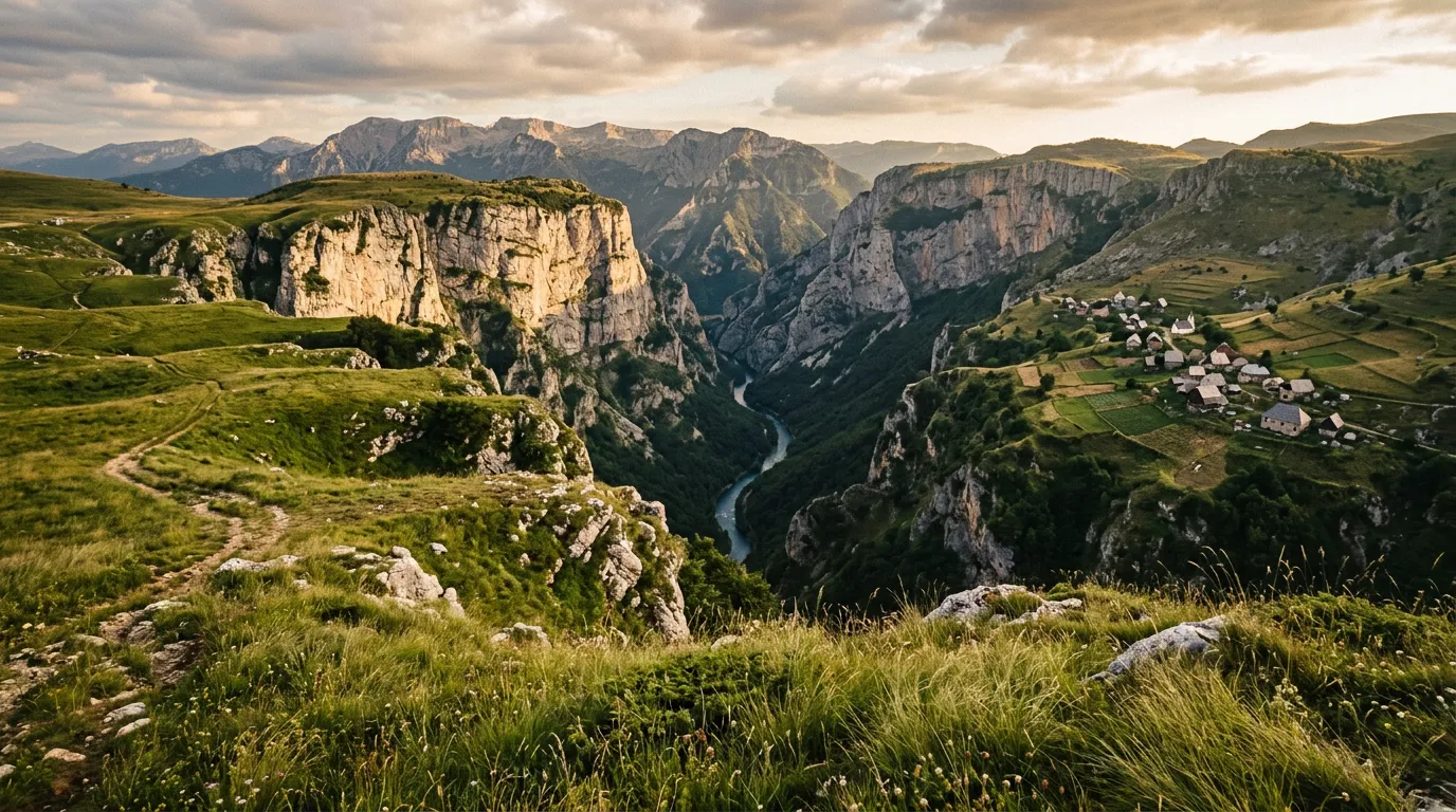
Lukomir village is the highest permanently inhabited settlement in Bosnia at 1,495 meters. Stone houses with traditional stone-slab roofs, livestock in the surrounding meadows, and a location on the edge of the Rakitnica canyon that gives the village a vertiginous setting. Lukomir is seasonal — residents traditionally move to lower villages for the winter and return in spring. Visit in July-September for the best chance of finding the village occupied.
The walk to the canyon rim from Lukomir takes fifteen minutes and delivers a view that justifies the gravel road: the Rakitnica gorge drops nearly a thousand meters to the river below, and the opposite wall rises in layers of exposed limestone that catch the light differently hour by hour.
Afternoon: Descent to Konjic
From the Bjelasnica plateau, the traverse descends southward toward the Neretva valley. The road options here depend on conditions and your appetite for adventure:
Option A (recommended): Return to the main Bjelasnica approach road and descend to Hadzici, then take the secondary road south through Tarcin to Konjic. This route is entirely paved, follows a river valley through forested hills, and arrives in Konjic from the north.
Option B (adventurous): Continue on the highland gravel tracks from the Bjelasnica plateau southward toward Umoljani village and beyond. This route is spectacularly scenic but the roads are poor — unpaved, narrow, and in places barely distinguishable from the landscape. Only for vehicles with good clearance and drivers comfortable with uncertainty. Check locally before attempting.
Konjic
Konjic is a small town at the confluence of the Neretva and Rakitnica rivers, and it is a better overnight stop than its modest size suggests. The old town has an Ottoman bridge (a smaller cousin of Mostar’s Stari Most), riverside restaurants, and a handful of guesthouses. The town was on the front lines during the 1990s conflict, and remnants of that period are visible but integrated into a place that is firmly focused on the present.
Konjic is also the access point for Tito’s nuclear bunker (ARK D-0), a massive underground facility built to shelter Yugoslavia’s leadership during a nuclear war. Tours are available and worth the detour — the bunker is a Cold War time capsule, preserved almost exactly as it was when it was decommissioned.
Day 2: Konjic to Mostar via Prenj
| Distance: 110km | Drive time: 4-5 hours |
The Neretva gorge
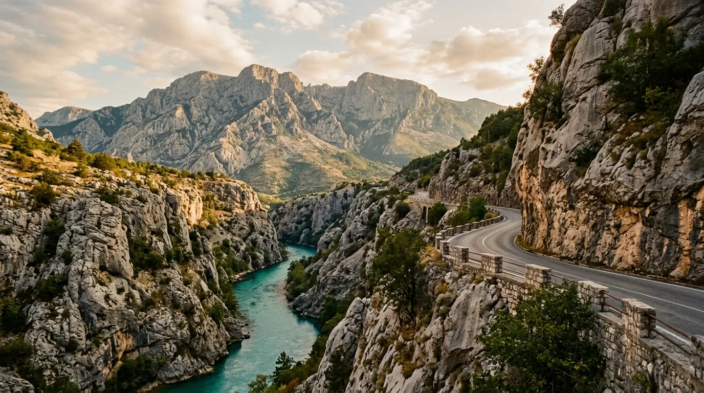
Leave Konjic heading south on the M17, the main road following the Neretva River toward Jablanica. This section is not a mountain road — it is a two-lane highway through a river gorge — but the scenery is outstanding. The Neretva is a powerful river that has carved a canyon through the Dinaric Alps, and the road follows its west bank through a corridor of vertical rock walls and rapids.
The gorge is narrow enough that the road, the river, and the railway share the same space, weaving around each other in a choreography of infrastructure that reflects the gorge’s limited width. The water is a shade of green-blue that photographers regularly accuse of being filtered. It is not.
Jablanica
Jablanica sits at the junction of the Neretva and Rama rivers, and its principal claim to fame is a bridge — or rather, the absence of one. During World War II, Yugoslav partisans destroyed the railway bridge over the Neretva during the Battle of the Neretva (1943), a key moment in the partisan campaign that later became a film, a legend, and a museum.
The Museum of the Battle of the Neretva preserves the destroyed bridge and a locomotive left at the canyon edge. It is melodramatic in presentation and genuinely moving in content. Allow 30-45 minutes.
Jablanica also has fuel, food, and a view of Prenj mountain that sets up the afternoon’s driving.
The Prenj traverse
Prenj (2,155m) is the most dramatic mountain in Herzegovina — a jagged limestone massif that rises abruptly from the Neretva valley with the aggression of a geological argument. The mountain is not crossed by a road (no road could survive Prenj’s terrain), but the route from Jablanica to Mostar passes along its western flank, and the views upward into the mountain’s gorges and cliff faces are constant companions for thirty kilometers.
The key section is the old road from Jablanica south toward Mostar, rather than the new A1 motorway. This old road — the M17 — follows the Neretva through a series of small towns and gorge sections, climbing over a low saddle at roughly 500 meters before descending toward Mostar. The driving is not technical, but the scenery is extraordinary.
The old road passes through:
Doljani — a village at the base of Prenj’s western cliffs, where the mountain rises directly from the roadside in a wall of grey limestone that makes you crane your neck until your passenger reminds you to watch the road.
Bijela — a small town where the Neretva widens briefly and the gorge opens to reveal the Prenj massif from a new angle. Good place to stop for photographs.
Potoci/Salakovac — the gorge narrows again as you approach Mostar, and the road shares the riverbank with hydroelectric infrastructure. The landscape transitions from mountain to Mediterranean — olive trees appear, the air warms, and the vegetation shifts from deciduous forest to scrub and stone.
Old road vs. motorway
The A1 motorway between Jablanica and Mostar runs through a series of tunnels and viaducts that bypass the Neretva gorge entirely. It is faster by about forty minutes. It is also a study in how to traverse one of Europe’s most dramatic river gorges while seeing none of it.
The old M17 follows the river. Every kilometer of gorge, every cliff face, every rapids section is visible from the road. The trade-off is time and road quality — the M17 is well-maintained but narrow, with occasional truck traffic and limited overtaking opportunities. We consider this trade-off overwhelmingly in favor of the old road.
Arrival in Mostar
The traverse ends in Mostar, entering the city from the north along the Neretva. Mostar’s old town, centered on the rebuilt Stari Most (Old Bridge), is one of the most beautiful urban settings in the Balkans. The bridge was destroyed in 1993 during the Bosnian War and rebuilt using original Ottoman construction techniques, reopening in 2004.
Park on the outskirts (old town is pedestrian) and walk across the bridge. The Neretva flows turquoise beneath the arch, divers jump from the parapet for tourist tips, and the Ottoman-era buildings on both sides of the river create a setting that photography cannot adequately capture.
You have driven 200 kilometers from Sarajevo. The motorway would have taken two hours. This route took two days. The motorway would have shown you concrete barriers and tunnel lighting. This route showed you Olympic ruins, highland villages, a partisan museum, the Neretva gorge, Prenj’s cliff faces, and the rebuilt bridge of a city that refused to accept destruction as a permanent condition.
The arithmetic is simple.
Which car to rent
| Factor | Recommendation |
|---|---|
| Type | Standard car adequate for the full route. SUV recommended if including Lukomir gravel. |
| Engine | Any modern engine is fine. No extreme gradients on this route. |
| Transmission | Either. Manual slightly preferred for mountain sections. |
| Ground clearance | Standard for paved route. Higher clearance for Bjelasnica gravel tracks. |
| Fuel range | Plan for 90-100km gaps between stations on Day 1. |
Rent in Sarajevo (airport or city center). Return in Mostar (one-way drop fee typically applies, 30-50 EUR with local agencies) or plan a return to Sarajevo via the A1 motorway.
Practical information
| Detail | Information |
|---|---|
| Total distance | ~200km over 2 days |
| Total drive time | 7-9 hours |
| Best months | June-September for highland access. May and October possible but check Bjelasnica upper roads. |
| Fuel | Sarajevo suburbs, Konjic, Jablanica, Mostar. No fuel on Bjelasnica mountain or between Bjelasnica and Konjic. |
| Accommodation | Konjic (guesthouses, small hotels) or Bjelasnica plateau (mountain lodges, seasonal). |
| Currency | BAM (Convertible Mark). Cards accepted in towns, carry cash for mountain areas. |
| Language | Bosnian. English spoken in tourist areas (Sarajevo, Mostar), limited elsewhere. |
| Mines | Stay on paved roads and marked trails. Mine clearance is ongoing. See the note in our Bjelasnica guide. |
| Border crossings | None — entire route within Bosnia and Herzegovina. |
Individual area guides
- Bjelasnica Approaches — Olympic mountain, multiple routes, 1,500m, difficulty 2
The Sarajevo-to-Mostar corridor is one of the most traveled routes in the Balkans, and almost everyone takes the motorway. The mountain traverse exists for the minority who believe that the journey between two cities should show you the country that lies between them. Bosnia’s mountains are not famous. They do not have the Swiss reputation, the Norwegian drama, or the Romanian cinematic appeal. What they have is honesty — a landscape that does not perform for tourists, that carries its scars visibly, and that rewards the driver who slows down enough to see what the motorway was built to bypass.