Llogara Pass
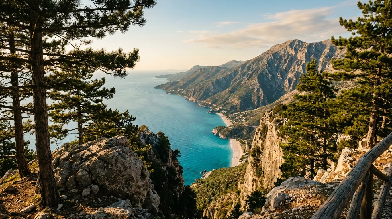
You spend forty-five minutes climbing through pine forest with no view of the sea. The road switchbacks up through the Ceraunian Mountains, each hairpin revealing another layer of green canopy, the gradient steady, the engine working quietly. Nothing about the drive prepares you for what happens at the top. You crest Llogara Pass at 1,027 meters, the forest opens, and the entire Albanian Riviera unfolds below you – a vertical drop of a thousand meters to a coastline of white-sand beaches, turquoise water, and limestone cliffs that plunge into the Ionian Sea. The transition is so abrupt, so total, that the first time we drove it, the passenger actually swore.
This is the Llogara Pass on Albania’s SH8 highway, and it is the single most dramatic mountain-to-coast transition we have driven in Europe. Not the highest pass. Not the most technical. Not the most dangerous. But the moment of revelation at the summit – the instant the landscape flips from alpine forest to Mediterranean coast without any gradual transition, like someone changed the channel – is unmatched. The Swiss passes are higher. The Norwegian roads are steeper. None of them do this.
Why drive Llogara Pass
The obvious answer is the view from the summit. But Llogara deserves more credit than a single viewpoint.
The pass sits in the Llogara National Park, a protected area of old-growth pine forest in the Ceraunian Mountains. The Ceraunians are a coastal mountain range – they rise directly from the Ionian Sea to over 2,000 meters in less than five horizontal kilometers, creating one of the steepest coastal gradients in Europe. The SH8 highway crosses this range at its most accessible point, the Llogara saddle, and the road traverses the full ecological spectrum: from olive groves and citrus orchards at sea level, through Mediterranean scrub, into dense pine forest, over the summit into alpine meadow, and then back down through the same zones in reverse on the other side.
The historical weight of the crossing is considerable. The Ceraunian Mountains have been a geographic and cultural barrier for millennia – the ancient Greeks called them the “thunder mountains” and considered them the boundary of the known world. Julius Caesar crossed somewhere near this pass while chasing Pompey during the civil war. The modern road follows a route that has been used since antiquity, though the surface has improved somewhat since Caesar’s time.
And there is the practical matter: the Llogara Pass is the gateway to the Albanian Riviera, the stretch of coastline between Vlora and Saranda that has become one of the Mediterranean’s last unspoiled coastal destinations. If you are driving to the Riviera from the north – from Tirana, Berat, or anywhere in central Albania – the Llogara Pass is the only road. You will cross it. The question is not whether to drive it, but whether to appreciate it properly while doing so.
Which direction to drive
North to south – Vlora to Himara. This direction delivers the great reveal at the summit: you climb through forest with no view of the sea, crest the pass, and suddenly the entire Riviera coast is laid out below you. The effect is cinematographic, and it works because the ascent conceals what the summit reveals.
Driving south to north (Himara to Vlora), you start with the coast visible and gradually lose it as you climb into the forest. It is still a beautiful drive, but it lacks the moment of revelation that makes the northbound approach special.
If you are making a round trip – which many drivers do, staying on the Riviera and returning the same way – you get both perspectives. But if you can only drive it once, go north to south.
Kilometer by kilometer
Km 0-8: Vlora to the foothills
The SH8 leaves Vlora heading south along the coast, passing the industrial port area and the beach resort of Orikum. The road is flat, two lanes, decent asphalt. To the right, the Bay of Vlora. To the left, the Ceraunian Mountains rising abruptly – a wall of limestone and green that you are about to climb.
The turn inland comes at the base of the mountains. The road leaves the coast and immediately begins climbing. The gradient shifts from flat to 6% in the span of a few hundred meters.
Km 8-18: The northern ascent
The climb through the northern slopes of the Ceraunian range is the gentler of the two sides. The road switchbacks up through pine forest on well-maintained asphalt, gaining altitude steadily. The hairpins are wide and well-sighted – this is a national highway, engineered for buses and trucks as well as cars. The gradient averages 6-7%, occasionally steepening to 8% on the tighter turns.
The forest here is old-growth Bosnian pine – tall, straight-trunked trees with a canopy that filters the light into patterns on the road surface. The air cools noticeably as you climb. Traffic is typically light outside of summer weekends. You may encounter a bus or truck on the switchbacks, requiring a brief wait at a wide point, but the road handles two-way traffic comfortably.
What you do not see during this section: the sea. The northern ascent faces inland, and the forest blocks any view of the coast. This is deliberate – or at least, it works as though it were deliberate. The road withholds the payoff.
Km 18-22: The summit and the revelation
The forest thins. The hairpins ease. The road levels off into the broad saddle of the Llogara Pass at 1,027 meters. There is a parking area, a restaurant, and several hotels that cater to hikers and paragliders.
And there is the view.
The southern face of the Ceraunian Mountains drops away in a near-vertical wall to the Ionian coast a thousand meters below. From the summit viewpoint, you can see the beaches of Dhermi, Gjipe, and Himara stretched along the coastline, the turquoise water impossibly vivid against the white limestone, and the island of Corfu floating on the horizon to the west. On clear days, which are most days in summer, the view extends to the Italian coast.
Stop here. Get out of the car. Walk to the viewpoint. Take the photograph. Then take it again because the first one did not capture the scale. Then accept that no photograph will capture the scale and just look at it for a while.
The Llogara National Park visitor center is at the summit, and trails lead to nearby peaks for those who want even higher viewpoints. The restaurant serves simple Albanian mountain food – grilled lamb, feta, bread – at prices that would buy you an espresso in Kotor.
Km 22-30: The southern descent to the Riviera
The descent to the coast is steeper and more dramatic than the ascent. The road drops sharply through switchbacks on the exposed southern face, with the Ionian Sea directly ahead and below. Guardrails are present on the tightest turns. The gradient reaches 10% in sections, and the hairpins are tighter than on the northern side – this is where the drive requires the most attention.
The views on the descent are continuous and distracting. Every switchback frames a different section of coastline. The temptation to stare at the sea instead of the road is strong. There are several marked pullouts for photography – use them instead of slowing to a crawl on the active road.
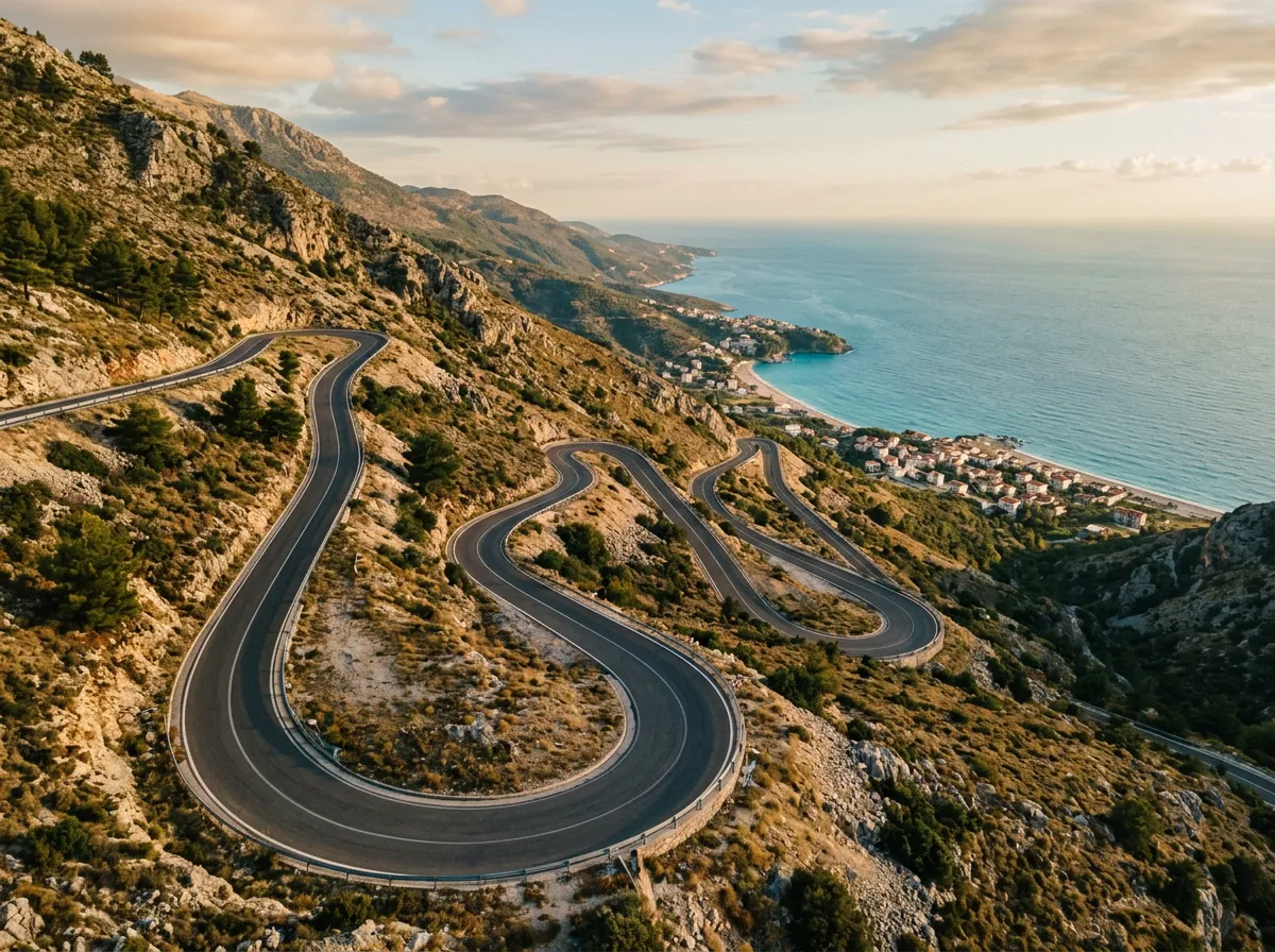
The road reaches sea level at the village of Palasa and continues south along the coast to Dhermi and Himara. The transition from mountain to beach happens in minutes – you go from pine forest and alpine air to olive trees, cicadas, and water warm enough to swim in. The gear shift, metaphorically and literally, is total.
Practical information
| Detail | Information |
|---|---|
| Opening dates | Year-round; snow may briefly close the summit in severe winters but this is rare |
| Toll | None |
| Fuel | Available in Vlora and Himara; no fuel on the pass itself |
| Parking | Free at summit viewpoint, restaurant, and national park |
| Best time | May-June and September-October for driving; July-August for combining with beach time |
| Avoid | Weekend afternoons in August (heavy tourist traffic to/from Riviera) |
| Drive time | 45 minutes to 1 hour without stops |
The Albanian Riviera beyond the pass
If you are crossing Llogara to reach the Riviera, the coastline south of the pass offers some of the best beaches in the Mediterranean. Key stops:
- Gjipe Beach: Accessible via a rough track (1km walk from the road) – secluded, dramatic, no facilities
- Dhermi: Expanding beach village with restaurants and accommodation; the longest beach on this stretch
- Porto Palermo: Ottoman-era fortress in a sheltered bay; photogenic and uncrowded
- Himara: The largest Riviera town; good base for exploring, with waterfront restaurants and a hilltop old town
Year-round accessibility
Unlike most mountain passes in this guide, Llogara is usable year-round. The 1,027-meter elevation is low enough that heavy snowfall is rare, and the road is maintained as a national highway. In winter, temperatures at the summit drop to near-freezing, and ice is possible on the road surface in early morning – but full closures are uncommon. This makes Llogara an excellent winter mountain drive when Alpine passes are buried under meters of snow.
Car rental and vehicle notes
Any car handles Llogara Pass. The SH8 is a national highway maintained for commercial traffic – buses and trucks cross it daily, and the asphalt surface is good throughout. A standard rental sedan is perfectly adequate.
In Albania, car rental is available in Tirana (widest selection, best prices), Vlora (limited options), and Saranda (a few agencies). Expect to pay 25-40 EUR per day for a basic compact. International companies (Hertz, Europcar) operate from Tirana airport. Local agencies are often cheaper but read the insurance terms carefully.
One note on driving habits: the SH8 carries significant local traffic, and Albanian driving customs are more assertive than Western European norms. Overtaking on the ascent – even on blind hairpins – is not uncommon. Drive defensively, stay right, and do not assume the lane ahead is clear just because it appears empty. This is not a criticism; it is a factual observation that helps you calibrate your expectations before the first switchback.
The paragliders
Llogara Pass is one of Europe’s best sites for tandem paragliding, and on summer days you will see paragliders launching from the summit and soaring over the Riviera coastline a thousand meters below. If this appeals to you, flights are available from operators at the summit (approximately 60-80 EUR for a tandem flight). The combination of driving the pass and then flying off it provides two perspectives on the same geography that complement each other remarkably. You see the switchbacks from above. You see the coast from the air. You understand the vertical relationship between mountain and sea in a way that neither the drive nor the flight alone conveys.
Combine with nearby passes
Llogara is a natural component of the Albanian Mountain Triangle, a four-day itinerary that combines this coastal pass with the Theth Road in the Albanian Alps and the mountain roads of central Albania. The contrast between Llogara’s Mediterranean warmth and Theth’s Alpine severity makes the combination one of the most varied mountain driving experiences in Europe.
For a cross-border extension, the drive from the Albanian Riviera to Montenegro’s Kotor serpentines is achievable in a day via the coastal road through Saranda and the border at Muriqan. Alternatively, head inland from Himara through the Vjosa Valley toward Permet, where the mountain roads of southern Albania offer a completely different driving character – narrower, rougher, and far less trafficked than the SH8.