Theth Road
The Albanian Alps have a name that the locals use and the tourists have adopted: the Accursed Mountains. The Bjeshket e Nemuna. Nobody agrees on why they are cursed – theories range from the difficulty of crossing them to the blood feuds they once sheltered to the simple fact that they are hostile, vertical, and unforgiving to anyone who enters unprepared. Whatever the etymology, the name fits the road. The Theth Road climbs 42 kilometers from the shores of Lake Shkodra to the alpine valley of Theth at 750 meters, crossing a pass at 1,630 meters through mountains that have more in common with the Dolomites than anything you would expect in Albania. The road was recently improved – concrete and fresh asphalt replaced the worst gravel sections – but “improved” is a relative term. This is still a mountain track through one of the most rugged ranges in Europe, and it still demands respect, skill, and a vehicle with ground clearance.
We first drove the Theth Road in 2019, before the improvements, when it was a full-commitment gravel track that took four hours and left us genuinely uncertain whether we would make it. We drove it again in 2024, and the difference was significant – the lower half is now paved, the worst switchbacks have been concreted, and the time has dropped to roughly two hours. But the upper section remains narrow, partially unpaved, and exposed to drops that no amount of concrete can make comfortable. The Accursed Mountains have been tamed slightly, but they have not been domesticated.
Why drive Theth Road
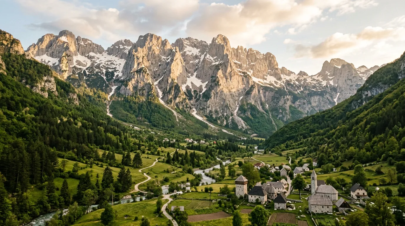
Theth is the most spectacular alpine valley in the Balkans. That is not hyperbole – it is simply what happens when you place a traditional stone village in a valley surrounded by 2,500-meter limestone peaks with waterfalls cascading from vertical cliff faces. The Theth National Park contains the Blue Eye (Syri i Kalter) spring, the Grunas Waterfall (a 30-meter cascade into a natural pool), a functioning lock-in tower from the era of Albanian blood feuds, and hiking trails that connect through the mountains to neighboring Valbona – the famous Valbona-Theth trail that has become one of Europe’s most sought-after day hikes.
But this guide is about the road, and the road is why many people come. The Theth Road is the only way into the valley by car, and it is an experience in itself. The climb from the Shkodra lowlands into the Albanian Alps compresses an enormous amount of geographic change into 42 kilometers: you start in Mediterranean warmth at the lakeshore, climb through oak forest, enter dense beech woodland, break above the treeline into bare limestone, cross the pass, and descend into the alpine valley. The vegetation zones change every ten minutes. The temperature drops by degrees you can feel.
And the mountains. The Albanian Alps are limestone karst at their most extreme – vertical walls, sharp ridges, deep gorges. The peaks around Theth reach 2,500 meters and have the angular, aggressive profile that earned them the “accursed” name. On the road, these peaks frame every viewpoint and close in around every switchback. They are not background scenery. They are the landscape, and the road is an intrusion into their territory.
Which direction to drive
South to north – Shkodra to Theth. The climb from Shkodra builds the drama properly: you ascend from a lowland lake through progressively more dramatic terrain, cross the pass at the climax of the drive, and descend into the valley as the reward. The arrival in Theth – valley opening up, peaks on both sides, waterfall visible in the distance – is a moment worth building toward.
The reverse (Theth to Shkodra) starts with the valley and ends in the flatlands, which is deflating. You will likely drive both directions regardless, since Theth is a dead end – the same road in, the same road out (unless you hike to Valbona and arrange a car on the other side). But if you are choosing which direction to drive first, make it the ascent.
Kilometer by kilometer
Km 0-10: Shkodra to the mountain base
The road begins at the roundabout on the northern edge of Shkodra, Albania’s fourth-largest city and the gateway to the Albanian Alps. Follow signs for Theth – the route heads north along the eastern shore of Lake Shkodra, passing through flat agricultural land and the occasional village. The road is paved and two lanes, the driving unremarkable. The mountains are visible ahead, rising like a wall.
The last village before the climb is Boga, where the road narrows and the gradient begins. There is a small shop here – your last chance for supplies. Beyond Boga, there is nothing until Theth.
Km 10-22: The lower ascent (improved section)
The road enters the mountains and the transformation begins. Fresh asphalt or concrete has been laid on most of this section, replacing the gravel that made the lower climb a teeth-rattling experience. The surface is good, the gradient a steady 6-8%, and the switchbacks are wide enough for two-way traffic with some negotiation.
The forest here is dense mixed oak and beech, the trees closing in on both sides. The road feels enclosed – you climb through a green tunnel with occasional glimpses of the peaks above the canopy. The altitude gain is steady: by km 15, you are above 800 meters and the air is noticeably cooler.
Traffic on this section can include minibuses bringing hikers to Theth, construction vehicles (the road improvements are ongoing), and the occasional local driving a car that should not technically be on this road but somehow is.
Km 22-32: The upper ascent and pass
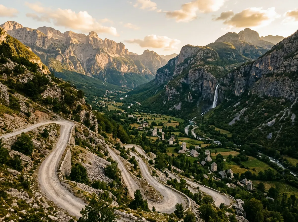
This is where the road remembers it is in the Accursed Mountains. The paved sections give way to a mix of concrete, gravel, and packed dirt. The width narrows to a single lane with passing places. The switchbacks tighten. The forest thins, exposing bare limestone above and, increasingly, drops below.
The gradient reaches 10% in sections. The hairpins number roughly twenty, though counting becomes unreliable when some turns are tight U-bends and others are broader curves. The surface requires attention – loose gravel on concrete transitions, occasional rocks on the road from minor slides, ruts where water has channeled across the track.
The pass itself sits at approximately 1,630 meters in a broad saddle between two ridgelines. The landscape at the summit is stark and beautiful: bare grey limestone, alpine grass, and the peaks of the Accursed Mountains rising on both sides to over 2,000 meters. A small parking area allows you to stop and absorb the position – you are in the middle of the Albanian Alps, at the highest point of the road, surrounded by mountains that have been a natural fortress for centuries.
The wind at the Theth pass is something we did not expect. It funnels through the saddle between the ridges with enough force to rock the car. When we stepped out to photograph the view, the wind was cold enough to make us put on jackets in July. The mountains were generating their own weather, and we were standing in the middle of it.
Km 32-42: Descent to Theth
The descent into the Theth Valley is the reward. The road drops from the pass through a series of tight switchbacks on the northern face – still narrow, still partially gravel, but now descending toward something visibly beautiful. The valley opens up below: green meadows, the river glinting in the sun, the stone buildings of Theth village scattered across the valley floor, and on the far side, the Grunas Waterfall dropping from a cliff face into the forest.
The gradient is steep on this side – 8-10% sustained, with the switchbacks demanding low gear and steady braking. A manual transmission is a significant advantage here. The road delivers you into the valley floor at roughly 750 meters, from where it is a flat kilometer to the village center.
Theth village has guesthouses (1,500-3,000 ALL per night including dinner, roughly 15-30 EUR), simple restaurants, and the trailhead for the Valbona hike. There is no fuel, no ATM, and cell service is limited to one carrier with a weak signal. You are genuinely remote, which is part of the point.
Practical information
| Detail | Information |
|---|---|
| Opening dates | May through October; road cleared of snow by late May in normal years |
| Toll | None; Theth National Park fee 200 ALL (approximately 2 EUR) |
| Fuel | Last fuel in Shkodra; no fuel on the road or in Theth |
| Parking | Free in Theth village; informal parking at the pass summit |
| Best time | June through September; late June for wildflowers, September for fewer crowds |
| Avoid | After heavy rain (gravel sections become slippery); winter (road closed by snow Nov-May) |
| Drive time | 2-3 hours one way |
Vehicle requirements
The Theth Road does not strictly require a 4x4 since the improvements, but it strongly rewards high ground clearance. A standard sedan can theoretically make it in dry conditions, but the gravel sections, the occasional water crossing, and the ruts on the upper road make a vehicle with at least 170mm of clearance much more comfortable.
Our recommendation: a compact SUV or crossover is the sweet spot. Something like a Dacia Duster, Suzuki Vitara, or similar – enough clearance for the rough sections, not so large that the narrow switchbacks become stressful. A proper 4x4 is overkill in dry conditions but provides peace of mind in wet weather.
Manual transmission is strongly preferred for the steep descent into Theth. Engine braking on a 10% gravel gradient is not optional – it is essential.
The Valbona alternative
Many visitors to Theth combine the drive with the Valbona-Theth hiking trail – a 6-8 hour trek over the Valbona Pass at 1,795 meters that connects the two premier valleys of the Albanian Alps. The common itinerary: drive to Theth, hike to Valbona, ferry across Koman Lake, return to Shkodra. If you are doing this, the driving component is one-way only, and you can arrange a car transfer through your Theth guesthouse.
For drivers who want both valleys without the hike, the road from Shkodra to Valbona via Koman (including the ferry across Koman Lake) is a separate adventure entirely – slower, rougher, and arguably more dramatic than the Theth Road.
Combine with nearby passes
The Theth Road is the northern anchor of the Albanian Mountain Triangle, a four-day itinerary that connects the Albanian Alps with southern Albania’s Llogara Pass via the mountain roads of the interior. The contrast between Theth’s alpine severity and Llogara’s Mediterranean warmth makes the combination particularly satisfying – you experience Albania’s full geographic range in four days.
For a purely alpine extension, the mountain roads east of Shkodra toward Kosovo (via the Qafa e Prushit pass) offer additional driving at similar altitude and difficulty. And if you are continuing north into Montenegro, the road from Shkodra to Podgorica is a three-hour drive that connects to the Montenegro Mountain Loop starting in Kotor.