Montenegro Mountain Loop
Montenegro is a country the size of Connecticut that contains a UNESCO-listed fjord, the deepest canyon in Europe, and a vertical range from sea level to 2,523 meters. You can drive from the Adriatic coast to a mountain pass higher than most Alpine resorts in three hours. The Montenegro Mountain Loop does exactly that – and then some – in three days, chaining the famous Kotor serpentines with Sedlo Pass at 1,907 meters and the Durmitor Ring Road around the Tara River Canyon. It is 280 kilometers of road that takes you from swimsuit weather to conditions where you want a jacket and a hat, through landscape that changes so completely you will question whether you are still in the same country.
We are. Montenegro is just built that way – vertically. And this itinerary follows the vertical line from bottom to top and back, with enough switchbacks to keep the steering wheel interesting and enough scenery changes to prevent any single view from becoming familiar.
Route overview
| Day | Route | Distance | Key Highlights |
|---|---|---|---|
| 1 | Kotor → Cetinje/Niksic | 70km | Kotor serpentines (25 hairpins), Bay of Kotor views, Lovcen National Park, old royal capital Cetinje |
| 2 | Niksic → Zabljak via Sedlo Pass | 80km | Karst plateau, Sedlo Pass at 1,907m, alpine transition, arrival at Durmitor |
| 3 | Durmitor Ring Road → return | 130km | Tara River Canyon, Djurdjevica Tara Bridge, Black Lake, return to coast or fly from Podgorica |
The loop can be driven in either direction, but coast-to-mountains (as outlined) provides the most satisfying progression: you start with the familiar Mediterranean, climb through increasingly dramatic terrain, and peak at Durmitor – both literally and figuratively.
Day-by-day breakdown
Day 1: Kotor serpentines to Cetinje
| Distance: 70 km | Drive time: 2-3 hours | Difficulty: 3 |
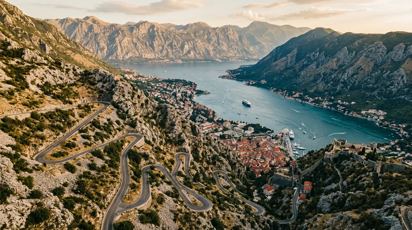
The day begins in Kotor, the fortified medieval town wedged between limestone cliffs and the inner Bay of Kotor. If you have not walked the town walls at dawn (before the cruise ship passengers arrive), do that before you start driving. Then get in the car and head for the serpentines.
The Kotor serpentines – the P1 road climbing from the Old Town to the Krstac Pass above – are 25 hairpin turns ascending from sea level to 940 meters in roughly 8 kilometers. The road was built by the Austro-Hungarian Empire and has been alarming drivers ever since. The hairpins are tight, the gradient is sustained at 10-12%, and the views of the Bay of Kotor below improve with every turn. This is Montenegro’s signature drive, the one that appears in every travel article and every car advertisement filmed in the Balkans.
The reality matches the reputation. The bay unfolds beneath you as you climb – Kotor’s orange roofs shrinking, the fjord’s branches extending, the mountains on the far shore growing as you gain their altitude. By hairpin 15, you can see the entire inner bay. By hairpin 25, the Adriatic is visible beyond the bay’s mouth. The road is narrow in places, and tourist traffic in summer can make the switchbacks a test of patience rather than skill. Start early.
At the top of the serpentines, the road enters the Lovcen National Park. The Montenegrin landscape transforms immediately – from Mediterranean coast to barren karst highlands in the span of a few switchbacks. Continue to Cetinje, the old royal capital, which sits at 672 meters on a small plateau surrounded by mountains. Cetinje is quiet, faded, and charming – former embassies from the era when Montenegro was a kingdom, a monastery housing important relics, and restaurants where a full lunch costs what a coffee costs in Kotor.
Option: If you want to push further on Day 1, continue from Cetinje to Niksic (another 50km on a good highway), which puts you closer to Sedlo Pass for Day 2. Both towns have adequate accommodation.
Where to stay: Cetinje: Grand Hotel or guesthouses in the old town (30-60 EUR). Niksic: Hotel Onogost or similar (30-50 EUR).
Day 2: Sedlo Pass to Zabljak
| Distance: 80 km (from Niksic) | Drive time: 2-3 hours | Difficulty: 3 |
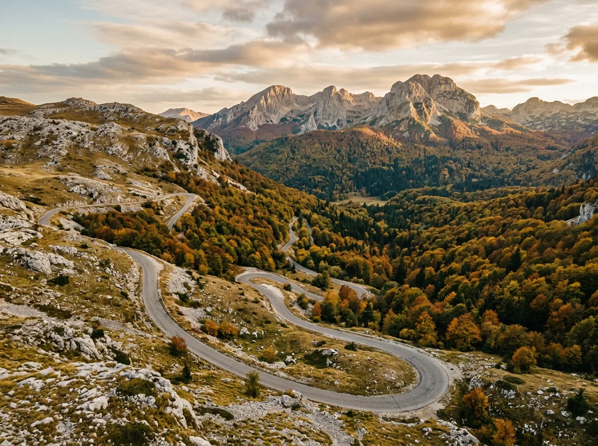
The centerpiece of the loop. Today you cross from Montenegro’s interior plateau to the Durmitor highlands via Sedlo Pass at 1,907 meters – the highest paved road in the country.
If starting from Cetinje, drive to Niksic first (1 hour on the E762). From Niksic, the road to Sedlo heads north into increasingly barren karst landscape. The detailed kilometer-by-kilometer guide is in the Sedlo Pass article, but the experience in summary:
The southern approach crosses a stone desert. Bare limestone, sparse grass, no trees, no villages, no cell service. The road climbs steadily through this austere landscape, gaining altitude without drama but with mounting atmosphere. The switchbacks are manageable, the gradient is sustained, and the emptiness is the defining feature.
At the summit – 1,907 meters, unmarked except for a stone cairn – the world changes. To the north, the peaks of Durmitor appear. To the south, the karst plateau stretches away toward the invisible coast you left yesterday. You are standing at the boundary between Mediterranean and continental Montenegro, between coast and interior, between tourist infrastructure and genuine wilderness.
The northern descent drops into forest, temperature, and color. Within thirty minutes of the summit, you are in dense beech and pine woodland, the road winding down through curves that feel almost leisurely after the stark climb. The road joins the E762 near Zabljak, and you arrive at the base of Montenegro’s highest mountain range.
Where to stay: Zabljak: numerous guesthouses and small hotels (30-70 EUR). Autocamp Razvrsje and Hostel Hikers Den for budget options. Hotel Zabljak for more comfort.
Fuel: Fill up in Niksic. There is fuel in Zabljak, but the Sedlo crossing has none.
Day 3: Durmitor Ring Road and return
| Distance: 130 km (ring road + return) | Drive time: 4-6 hours | Difficulty: 3 |
The final day loops around the Durmitor massif on the Durmitor Ring Road – 80 kilometers through the Tara River Canyon, around the national park, and back to Zabljak. This is the payoff for the two days of climbing: the deepest canyon in Europe, glacial lakes, and limestone peaks rising above the forest line.
Start early for the best light in the Tara Canyon. Drive clockwise from Zabljak to hit the canyon viewpoints and the Djurdjevica Tara Bridge in the morning, before tour groups arrive. The bridge – 172 meters above the river – is the focal point of the loop. Stop, walk across, look down. Then continue around the southern side of the massif through forest and meadow.
Stop at Black Lake on the return leg. It is a short walk from the road and one of the most photogenic spots in Montenegro – dark water reflecting pine forest and limestone peaks.
After completing the ring road, you have options for return:
Option A – Return to the coast via Sedlo (4 hours): Retrace Sedlo Pass south to Niksic, then continue to Podgorica (1 hour) and the coast. This route passes through Podgorica, which has the country’s main airport if you are flying out.
Option B – Scenic route via Tara gorge to coast (5-6 hours): From Zabljak, drive south via Pljevlja and the Tara River road to Mojkovac, then through the Moraca Canyon to Podgorica. Longer but the Moraca Canyon is spectacular and avoids re-crossing Sedlo.
Option C – Continue to Bosnia (3 hours): From Zabljak, drive north through Pljevlja to the Bosnian border. The road follows the Drina River toward Foca and eventually Sarajevo. This is an excellent extension if you have more days.
Which car to rent
The Montenegro Mountain Loop does not require a 4x4. Any competent car with functioning brakes and reasonable engine power will handle the entire route. That said, not all rental cars are created equal for mountain driving:
| Feature | Minimum | Recommended |
|---|---|---|
| Engine | 1.2L petrol | 1.4L+ petrol or diesel |
| Transmission | Any | Manual (for engine braking on descents) |
| Ground clearance | Standard | Standard is fine |
| A/C | Nice to have | Essential in summer (you’ll go from 35C coast to 15C summit) |
The Kotor serpentines, Sedlo Pass, and Durmitor Ring Road are all paved. The steepest sustained gradients (Kotor serpentines at 10-12%) are the most demanding section for the engine, but any modern car handles this without issue. What matters more is brake condition – three days of mountain driving with sustained descents will test brakes that are already worn. If the rental car has spongy brakes, exchange it before you start.
Rental pickup: Kotor, Tivat airport, or Podgorica airport. Tivat is closest to the start of the loop. Podgorica is the largest airport and offers the widest rental selection.
Practical information
| Detail | Information |
|---|---|
| Best months | June and September (warm, less crowded); October for autumn colors on Durmitor |
| Total budget (car + fuel + accommodation) | 300-500 EUR for two people, three days |
| Fuel planning | Fill in Kotor, Niksic, and Zabljak; the ring road and Sedlo have no stations |
| Toll roads | None on this route |
| Border crossings | None (entirely within Montenegro) |
| Altitude range | 0m (Kotor) to 1,907m (Sedlo Pass) |
| Cell service | Good on coast and in towns; patchy to absent on Sedlo Pass and parts of the ring road |
Season timing
- May: Sedlo Pass may still have snow patches; Durmitor is opening for the season; coast is warm but not hot
- June-August: Full season everywhere; coast is hot and crowded; mountains are perfect
- September: Ideal month – coast still warm, mountains cooling, tourist crowds thinning
- October: Autumn colors in Durmitor beech forests; Sedlo Pass getting cold; possible early closure
Photography tips
The three key photo opportunities:
- Kotor serpentines: Stop at hairpin 10-12 for the classic bay view. Morning light (east-facing) is best.
- Sedlo Pass summit: Wide panoramic; afternoon light catches the Durmitor peaks to the north.
- Djurdjevica Tara Bridge: The bridge itself is the subject; morning light avoids shadows in the canyon.
Why this loop works
Montenegro’s geography is absurd in the best possible way. The country is roughly 160 kilometers from coast to its northern mountain border, and in that distance it manages to fit a fjord, a limestone plateau, a 1,907-meter pass, Europe’s deepest canyon, and a glaciated mountain massif. The Montenegro Mountain Loop exploits this compression ruthlessly – three days of driving and you have experienced a geographic diversity that most countries spread across a thousand kilometers.
The loop also works logistically. There are no border crossings, no toll roads, no vehicle permits. Fuel is available in every overnight stop. Accommodation ranges from budget to comfortable but never requires advance booking outside of July and August. The roads are paved throughout, and while the quality varies, nothing on this route would surprise a driver with basic mountain road experience.
What might surprise you is how quickly Montenegro changes. You will eat fresh seafood in Kotor at lunch, drink Turkish coffee on the Sedlo summit in the afternoon, and sit by a fire in a Zabljak guesthouse in the evening. Three altitudes, three climates, three completely different versions of the same small country. That is the loop’s real value – not just the individual passes, but the transitions between them.
Individual pass guides
- Sedlo Pass – difficulty 3, Montenegro’s highest paved crossing
- Durmitor Ring Road – difficulty 3, Tara Canyon and Durmitor National Park loop