Durmitor Ring Road
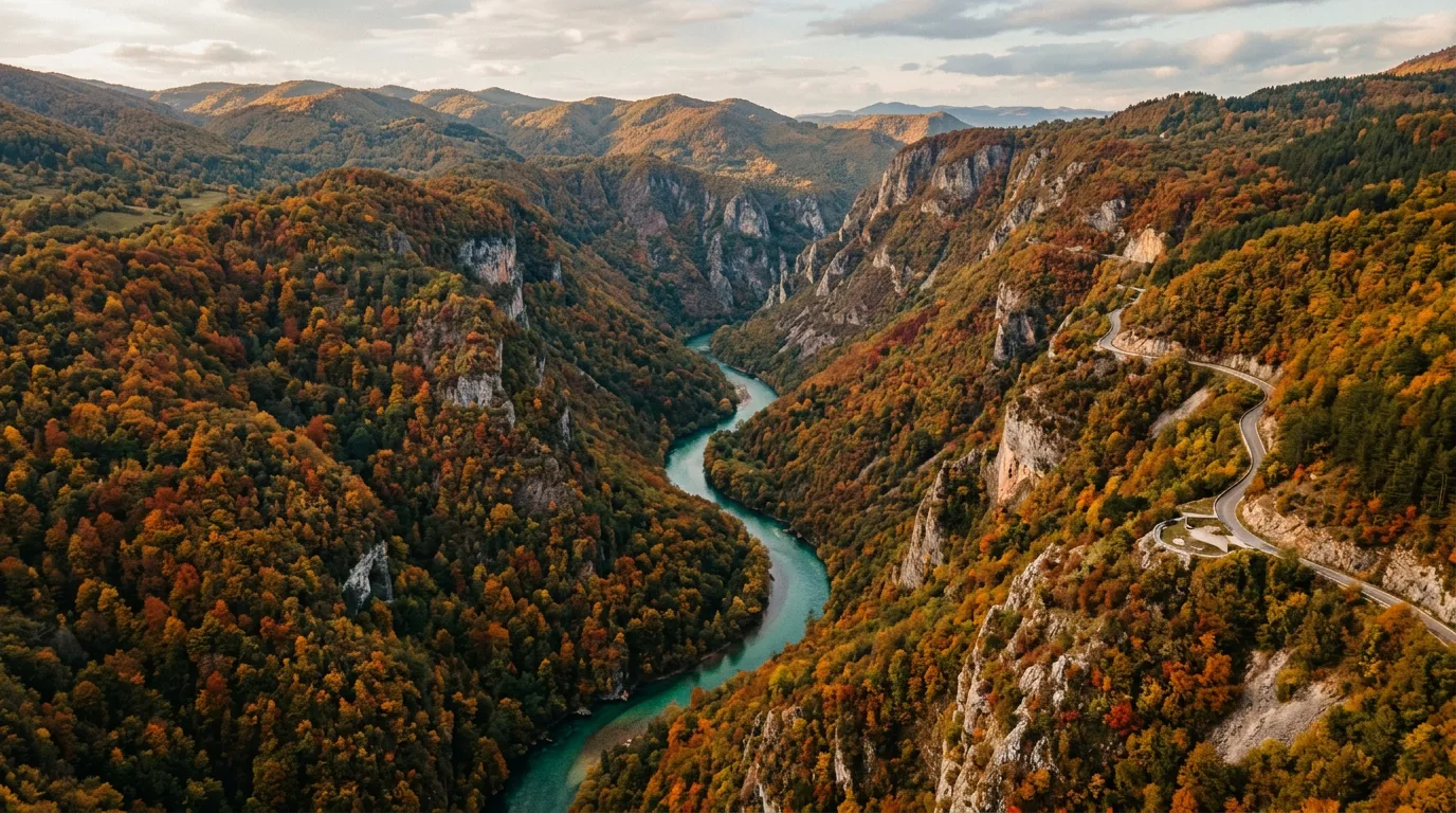
The Tara River Canyon is 1,300 meters deep. That number sounds abstract until you are standing at the rim, looking down at a thread of turquoise water far below, and then looking at the road that descends into the gorge on a series of switchbacks that someone in the Yugoslav road engineering department clearly designed while feeling ambitious. The Durmitor Ring Road loops 80 kilometers around Montenegro’s most dramatic national park, threading through the deepest canyon in Europe, passing glacial lakes with water so clear it looks like the earth forgot to fill them, and climbing back to 1,500 meters through limestone mountains that erupt from the ground like broken teeth.
We drove this loop on an October morning when the beech forests had turned the kind of gold that makes you question whether your eyes are calibrated correctly. The road was empty. The air was cold and sharp. Every switchback into the Tara Canyon revealed another shade of autumn reflected in the river below. It was, by any reasonable measure, one of the best 80-kilometer drives we have ever done.
Why drive Durmitor Ring Road
The Tara River Canyon is the headline. At 1,300 meters deep, it is the deepest canyon in Europe and second in the world only to the Grand Canyon. The comparison is apt in scale but misleading in character – where the Grand Canyon is arid and exposed, the Tara Canyon is densely forested, its walls covered in beech, pine, and fir, with the river running a vivid blue-green far below. The ring road traverses the canyon’s northern rim and descends into the gorge itself, giving you the perspective from above and below.
But the canyon is not the only reason. Durmitor National Park – a UNESCO World Heritage site since 1980 – is a high-altitude limestone massif with 48 peaks above 2,000 meters, 18 glacial lakes, and a botanical diversity that includes endemic species found nowhere else. The ring road circles the massif, and the landscape changes continuously: from river gorge to alpine meadow to limestone cliff to dark pine forest. Eighty kilometers of road, and no two kilometers look the same.
The driving itself is engaging without being extreme. The gradients are sustained but manageable. The switchbacks require attention but not white-knuckle grip. The road surface is asphalt throughout – patchy in places, but never disintegrating into the gravel chaos of more easterly mountain roads. This is a difficulty 3 drive that delivers difficulty 5 scenery.
Which direction to drive
Clockwise from Zabljak. The town of Zabljak sits at 1,456 meters on the Durmitor plateau and serves as the natural base for the loop. Driving clockwise takes you first to the Tara Canyon viewpoints and descent (the most dramatic section) while you are fresh, then around the southern flank of the massif through alpine meadows, and back to Zabljak via the quieter eastern approach.
The counterclockwise direction saves the canyon for the end, which some drivers prefer as a climactic finish. Both work. We slightly favor clockwise because the descent into the canyon feels more dramatic than the ascent – you see the depth opening up below you, which is more visceral than climbing out of a gorge you are already in.
Kilometer by kilometer
Km 0-5: Zabljak to the plateau edge
Zabljak is a small mountain town that serves as the gateway to Durmitor National Park. At 1,456 meters, it is the highest town in the Balkans, and on clear mornings the surrounding peaks catch the first light in a way that makes you want to stay and never start driving. Resist the urge. The loop is ahead.
Leaving Zabljak heading north, the road crosses the Durmitor Plateau – a high grassland dotted with scattered pine trees and the occasional shepherd’s hut. The driving is easy, the road straight and wide. This is the warm-up.
Km 5-25: Tara Canyon descent and gorge
The road reaches the canyon rim and everything changes. The plateau drops away to your right, and the Tara River appears far below – a turquoise line at the bottom of a vertical forest. Several marked viewpoints allow you to stop and absorb the scale. Use them. Photographs from a moving car do not capture the depth.
The descent into the gorge begins with a series of switchbacks – roughly eight turns over three kilometers, with a gradient of 8-10%. The road is two lanes but feels narrower as the canyon walls close in. Guardrails are present on the outside edges, metal barriers that look solid enough but somehow do not fully reassure when the drop behind them is measured in hundreds of meters.
At the bottom of the gorge, the road follows the Tara River. The water is extraordinarily clear – in shallow sections, you can see individual stones on the riverbed from the road above. This section of the river is a UNESCO-protected zone, and the lack of development along its banks gives the gorge a primeval quality.
The Djurdjevica Tara Bridge – a concrete arch bridge built in 1940, partly destroyed in World War II and rebuilt – crosses the canyon at a height of 172 meters. There is parking on both sides. Walk to the middle of the bridge and look down. Then look at the road you just descended and the road you are about to climb. This is the centerpiece of the loop.
Km 25-50: Southern traverse
After crossing the bridge, the road climbs out of the gorge on the southern side. The ascent mirrors the descent in gradient and switchback density, but the canyon views are now behind you and the landscape shifts to dense forest.
The southern section of the loop traverses the lower slopes of the Durmitor massif through mixed forest and occasional clearings. The road is quieter here – less traffic, fewer viewpoints, a more contemplative pace. The surface is good asphalt with occasional patches of rougher repair. There are no significant hairpins in this section, just sweeping curves through the trees.
Several small villages punctuate the route, with signs advertising domace (homemade) cheese and meat. If you are hungry, stop. The food in Montenegro’s mountain villages is simple, fresh, and usually better than anything in the tourist-oriented restaurants of Zabljak.
Km 50-65: The Piva approach
The road skirts the western edge of the Piva River valley, climbing gently through increasingly dramatic limestone terrain. The mountains here are raw and angular – exposed rock faces, sparse vegetation, a harshness that contrasts with the lush canyon forest earlier. On clear days, the views extend across the Montenegrin highlands to the distant peaks of the Albanian and Bosnian borders.
Km 65-80: Return to Zabljak
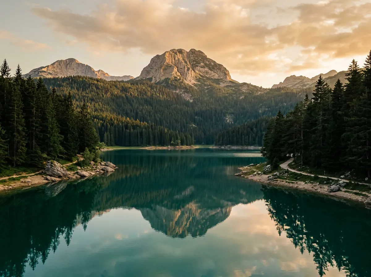
The final section curves back northeast toward Zabljak, climbing back to the plateau altitude. The road passes Black Lake (Crno Jezero), Durmitor’s most famous glacial lake and a short walk from the road. If time allows, stop here – the lake sits in a bowl surrounded by dark pine forest, with the peak of Medjed (2,287m) rising directly above. The reflections in still water are almost too perfect.
The road returns to Zabljak through familiar plateau terrain, completing the loop. Total driving time is 2-3 hours without stops, but you should allow 4-5 hours to do the viewpoints, the bridge, and Black Lake justice.
Practical information
| Detail | Information |
|---|---|
| Opening dates | May through October; road is technically open year-round but winter conditions can close higher sections |
| Toll | None for the ring road; Durmitor National Park entrance fee 5 EUR per day |
| Fuel | Available in Zabljak; no fuel on the ring road itself |
| Parking | Free at major viewpoints and Black Lake; small fee at Djurdjevica Tara Bridge |
| Best time | June and September (warm, less crowded); October for autumn colors |
| Avoid | July and August weekends (tour groups and rafting crowds on the canyon section) |
| Drive time | 2-3 hours continuous, 4-5 hours with stops |
Rafting the Tara
The Tara River is one of Europe’s premier whitewater rafting destinations, and half-day and full-day trips launch from various points along the canyon. If you have a spare day in Zabljak, a rafting trip provides the complementary perspective to the ring road drive – you see the canyon from below, looking up at the walls you drove along. Trips run May through October, roughly 50-80 EUR per person.
Road condition notes
The Durmitor Ring Road is maintained to a reasonable standard but not to the level of Western European mountain roads. Expect:
- Patchy asphalt in the gorge sections (occasional potholes that require attention)
- Narrow shoulders or no shoulders on canyon-edge sections
- Livestock on the road in rural sections (cattle, sheep, goats)
- Tour buses on the Djurdjevica Tara Bridge approach (summer)
None of these are deal-breakers, but they reward attentive driving. A car with decent suspension will handle everything comfortably.
Where to stay in Zabljak
Zabljak is small but well equipped for tourists. Accommodation ranges from 20 EUR hostel bunks to 80 EUR hotel rooms, with the sweet spot being family-run guesthouses in the 30-50 EUR range. These typically include breakfast (substantial) and can arrange dinner (recommended – the cooking is homestyle Montenegrin, which means slow-cooked meat, fresh bread, and kajmak that alone justifies the trip).
For location, stay near the town center for restaurants and evening atmosphere, or at one of the guesthouses near Black Lake for quiet and easy access to hiking trails. In summer (July-August), book at least a few days ahead – Zabljak fills up with hikers and rafters.
Best time for the ring road
- May-June: Snow melting, waterfalls at maximum flow, roads potentially damp. The Tara is at its most powerful. Few tourists.
- July-August: Peak season. Everything is open, weather is reliable, and the canyon is crowded on weekends. Best conditions, worst solitude.
- September: Our favorite month. Still warm enough for comfortable stops, tourist numbers dropping, the beech forests starting to turn.
- October: Autumn colors peak in the first two weeks. The ring road in full October color is almost unreasonably beautiful. Weather becomes unpredictable – carry layers and check forecasts.
Combine with nearby passes
The Durmitor Ring Road is one leg of the Montenegro Mountain Loop, a three-day itinerary that begins with the famous Kotor serpentines on the coast and works inland to Sedlo Pass and the Durmitor. The combination takes you from sea level to 1,907 meters – Montenegro’s full vertical range.
From Durmitor, you are also within striking distance of Bosnia’s mountain roads. The drive from Zabljak to Sarajevo via Foca follows the Drina River through gorges that rival the Tara, though without the same road quality. If you are heading south toward Albania, the route through Podgorica connects to the Llogara Pass within a day’s drive.