Sedlo Pass
Montenegro has a talent for hiding its best mountain roads behind its coastline. Everyone knows Kotor. Everyone drives the serpentines above the Bay of Kotor for the Instagram photograph. Almost nobody continues inland to the mountains where the real driving begins. Sedlo Pass, at 1,907 meters the highest paved road in Montenegro, sits in that interior – a remote crossing between the Niksic plateau and the Durmitor highlands that sees perhaps a dozen cars per hour on a busy summer day and far fewer in the shoulder months. We drove it on a Tuesday in late September and counted four other vehicles in 45 kilometers.
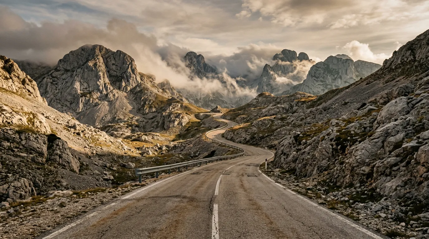
The pass is not flashy. It does not have the canyon spectacle of the Durmitor Ring Road or the coastal drama of the Kotor serpentines. What it has is altitude, solitude, and the kind of mountain landscape that makes you pull over not because a guidebook told you to, but because you cannot drive past it without stopping. Limestone peaks, alpine pastures yellowing into autumn, ravens circling above a ridge line, and a road that simply goes up, crosses over, and goes down, without fuss or tourist infrastructure or anything between you and the mountain.
Why drive Sedlo Pass
The primary appeal is the road itself. Sedlo Pass is a classic mountain crossing in the European sense – a single road over a high point, connecting two valleys, with no towns or settlements along the route. The 45-kilometer transit from Niksic to the Zabljak area crosses from the dry karst landscape of the Montenegrin interior to the lush, forested highlands of Durmitor, and the transition is dramatic. On the southern approach, the terrain is bare limestone – grey rock, sparse grass, a landscape that feels almost lunar. On the northern descent, the vegetation returns: first alpine meadow, then birch and pine, then dense beech forest. Two completely different ecosystems, separated by a road.
The altitude adds to the experience. At 1,907 meters, Sedlo is high enough that the climate shifts noticeably at the summit. Temperatures drop 8-10 degrees from the valley floor. Cloud formations at eye level are common – you drive through them, not under them. In late season the first frosts silver the grass at the summit while the valleys below are still warm. It is a tangible reminder that mountain passes are not just high roads; they are climate boundaries.
And then there is the emptiness. Montenegro’s coast gets roughly 2 million tourists per year. The interior, outside of Durmitor National Park itself, gets almost none. Sedlo Pass is the connective tissue between coast and mountains, and almost nobody bothers with the connection. They fly to Tivat, bus to Kotor, and never learn that two hours inland, Montenegro looks like a different country entirely.
We crossed Sedlo Pass at sunset once, returning from Zabljak to the coast. The summit was above the clouds. We could see the peaks of Durmitor piercing through the cloud layer to the north, and to the south, the karst plateau stretched away like a stone ocean. We sat on the guardrail and watched the light change for twenty minutes. Not a single car passed.
Which direction to drive
South to north – Niksic to Zabljak. This direction gives you the dramatic transition from barren karst to forested highlands, which feels like a reward after the austere southern approach. The northern descent into the Durmitor area is also more interesting from a driving perspective – longer, with more varied curves and better views.
That said, many drivers will take Sedlo Pass as part of a larger itinerary – either heading inland from the coast to Durmitor, or returning from Durmitor to the coast. In that case, direction is dictated by routing rather than preference, and the pass is excellent in both directions.
If you are combining Sedlo with the Durmitor Ring Road, drive Sedlo first (south to north), arriving at Zabljak for the ring road. If combining with the Kotor serpentines as part of the Montenegro Mountain Loop, you will likely cross Sedlo north to south on Day 3.
Kilometer by kilometer
Km 0-10: Niksic to the foothills
Niksic is Montenegro’s second-largest city, though the word “city” oversells it. It is a compact industrial town in the karst plateau of central Montenegro, surrounded by flat, rocky terrain that bears little resemblance to the postcard Montenegro of the coast. The road to Sedlo Pass heads north from Niksic, initially following a regional road through agricultural land and scattered villages.
The driving here is flat and unremarkable. The road is two lanes, asphalt, with light traffic. You are at roughly 600 meters altitude, and the mountains ahead are visible but still distant. The karst landscape is sparse – grey limestone outcroppings, dry grass, occasional olive groves. It is the kind of scenery that makes you wonder if you took the wrong turn. You did not.
Km 10-25: The southern ascent
The gradient begins. The road leaves the plateau and starts climbing into the mountain range that separates central Montenegro from the Durmitor highlands. The landscape becomes increasingly stark – bare limestone formations, sinkholes characteristic of karst geology, and an absence of trees that makes the road feel exposed even when the altitude is still moderate.
The switchbacks start at around km 15. They are well-spaced and not excessively tight – wide enough for comfortable passage, with sightlines that give you warning of oncoming traffic. The gradient sustains 6-8% through this section. The road surface is good asphalt with occasional rough patches.
The defining feature of the southern ascent is the scale. The karst landscape stretches away in every direction, grey and ancient, with the road as the only line of human intervention. No villages, no infrastructure, no cell towers. Just road and rock.
Km 25-30: The summit
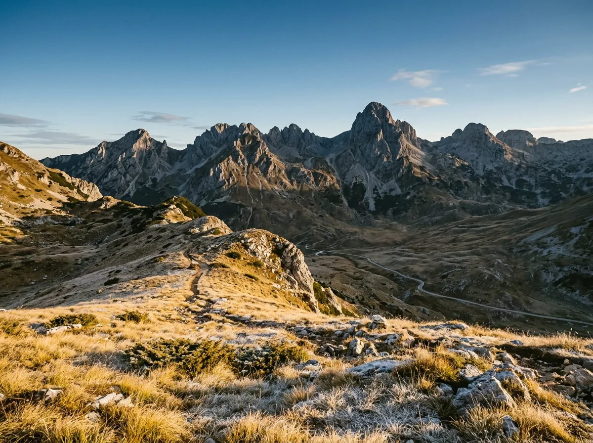
The approach to the summit levels off into a broad alpine saddle – the “sedlo” (saddle) that gives the pass its name. At 1,907 meters, you are above the treeline on the southern side, surrounded by alpine meadow and exposed rock. The summit area is wide and open, with panoramic views in every direction.
On clear days, you can see the peaks of the Durmitor massif to the north – Bobotov Kuk at 2,523 meters is visible, along with the serrated ridge of Sljeme. To the south, the karst plateau extends toward the invisible coast. The summit is unmarked except for a small stone cairn and whatever offerings previous travelers have left on it.
This is where you stop, whether or not you intended to. The combination of altitude, view, and solitude is too specific to drive past. There is no formal parking area – you pull onto the grass shoulder, which is wide enough. And you stand in the wind and look at what Montenegro looks like when nobody is watching.
Km 30-45: The northern descent
The northern side of Sedlo is a different world. Within a few kilometers of the summit, vegetation returns – first hardy alpine shrubs, then birch, then dense pine and beech forest. The air warms, the landscape softens, and the road descends through a series of sweeping curves that feel almost playful after the stark southern approach.
The gradient on the descent averages 6-7%, with occasional steeper sections. The curves are flowing rather than tight – this is road that invites a moderate pace rather than demanding a crawl. The forest closes in, creating corridors of green with occasional breaks where the view opens to reveal the Durmitor peaks above the treeline.
The road joins the E762 highway near the southern edge of the Durmitor area, from where it is a short drive north to Zabljak. The transition from Sedlo’s solitude to Zabljak’s modest tourist infrastructure feels abrupt – suddenly there are signs, other cars, a gas station.
Practical information
| Detail | Information |
|---|---|
| Opening dates | May through October; snow closes the summit section from late November to April |
| Toll | None |
| Fuel | Available in Niksic and Zabljak; no fuel on the pass |
| Parking | No formal parking; wide grass shoulders at the summit and viewpoints |
| Best time | June and September for weather; October for autumn colors in the northern descent |
| Avoid | Mid-winter (road closed); immediately after snowmelt (road damage common in May) |
| Drive time | 1-1.5 hours without stops |
Weather considerations
Sedlo Pass at 1,907 meters is high enough for significant weather variation. Summer temperatures at the summit can be 8-12 degrees cooler than Niksic. Fog at the summit is common in the morning and after rain. Snow is possible at the summit from late October through May. If driving in shoulder season (May or late October), check local conditions in Niksic or Zabljak before attempting the crossing.
Road condition details
The road surface on Sedlo Pass is generally adequate but not manicured. Expect:
- Good asphalt on the lower sections (both sides)
- Rougher asphalt with occasional cracks and patches near the summit
- Possible gravel or debris on the road after rainfall (small rockfalls in the karst sections)
- No road lighting anywhere on the pass
Drive during daylight. The combination of no lighting, inconsistent guardrails, and potential road debris makes a night crossing inadvisable.
Car rental and vehicle choice
Any car with a working engine and functional brakes handles Sedlo Pass without issue. The road is fully paved, the gradients are moderate, and ground clearance is not a concern. If you are renting specifically for this drive, a standard compact car is sufficient. If you are combining Sedlo with the Durmitor Ring Road (which you should), the same vehicle serves both routes.
In Montenegro, most visitors rent from Tivat airport or Podgorica airport. Tivat serves the coast and is closer if you are starting from Kotor. Podgorica is more central and has slightly wider selection. Rental prices start at approximately 25-35 EUR per day for a basic compact. A manual transmission is preferable for the sustained descents.
The emotional argument for Sedlo
We have included Sedlo Pass in this guide not because it is technically challenging or historically significant or photogenically famous. It is none of those things. We have included it because it is the pass that reminded us why we started driving mountain roads in the first place.
There is a quality to Sedlo that more famous passes lack: it is unperformative. No one is here to be seen. There are no viewpoint parking lots with selfie-optimized railings. There are no souvenir shops at the summit. There is just a road, a mountain, and whatever weather the Balkans decided to deliver that day. When you stop at the summit and stand in the wind and look at the mountains, the experience belongs to you completely. No one is photographing the same view from two meters to your left.
The famous passes are famous for good reason. But the quiet passes – the ones that nobody writes about, that appear in no listicles, that carry no traffic because nobody knows they are there – those are the passes that make you fall in love with mountain driving. Sedlo is that pass for Montenegro.
Combine with nearby passes
Sedlo Pass is the central link in the Montenegro Mountain Loop, connecting the coast (Kotor serpentines) with the mountains (Durmitor Ring Road). The three-day itinerary chains the Kotor hairpins, Sedlo crossing, and Durmitor loop into a single route that covers Montenegro’s full geographic range – sea level to 1,907 meters and back.
If you are heading north from Durmitor, the road toward the Bosnian border passes through the Tara River gorge. South from Niksic, the E65 descends to Podgorica and the coast. For a cross-border extension, the drive from Niksic to Albania’s Llogara Pass via Podgorica and the Albanian Riviera coast is achievable in a long day.