Tusheti Road (Abano Pass)
There is a moment on the Tusheti Road, roughly forty minutes after you leave the last paved surface behind, when the road narrows to the width of a single vehicle, the outside edge drops away into roughly a thousand meters of nothing, and you realize that the crumbling gravel under your right rear tire is the only thing between you and a very long, very final descent into the Alazani Valley. The road does not improve after this point. It gets worse. And you still have three hours of driving ahead. We drove it anyway, twice, and the second time we brought better tires.
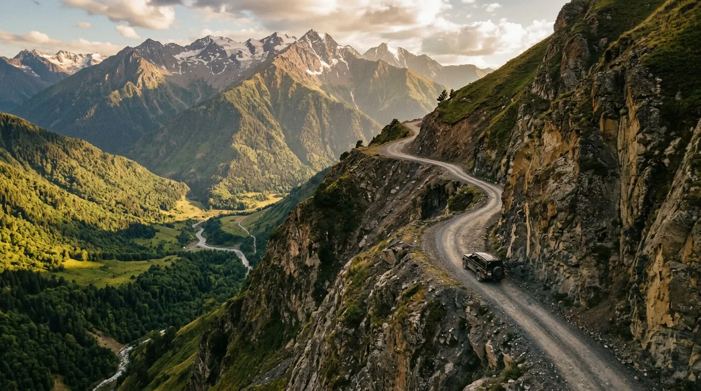
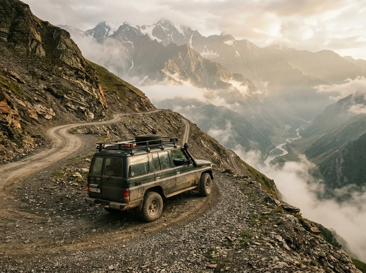
The Tusheti Road – officially the road from Pshaveli to Omalo via the Abano Pass at 2,926 meters – holds a reputation as the most dangerous road in Europe. Various travel outlets have given it that title, and for once the clickbait is not exaggerating. This is a 72-kilometer stretch of unpaved mountain track that climbs from 800 meters to nearly 3,000 meters on a surface that alternates between packed gravel, loose scree, and whatever the last rainstorm decided to rearrange. There are no guardrails. There is no cell service for most of the route. There are sections where the road has partially collapsed into the valley below and been rebuilt with the kind of casual engineering that suggests someone drove a bulldozer over once and called it finished.
People drive it because what waits at the other end – the medieval villages, fortress towers, and alpine meadows of Tusheti – is unreachable by any other road.
Why drive Tusheti Road
The obvious answer: Tusheti itself. The Tusheti region is one of the most remote inhabited areas in Europe, a cluster of medieval stone villages perched on mountain slopes at 1,800 to 2,400 meters, connected to the rest of Georgia by this single seasonal road and, since recently, a small airstrip with weather-dependent service. The villages of Omalo, Dartlo, and Diklo contain defensive stone towers dating to the 12th century, surrounded by high-altitude pastures where Tushetian shepherds still practice transhumance – moving their flocks between highland and lowland grazing on the same seasonal schedule their families have followed for centuries.
But there is a second reason people drive this road, and it is the road itself. The Tusheti Road is not an obstacle to be endured on the way to a destination. It is the experience. The drive demands a level of focus, skill, and nerve that turns 72 kilometers into a full-day undertaking. You will cross rivers without bridges. You will navigate switchbacks where three-point turns happen at cliff edges. You will meet cargo trucks on blind corners and one of you will have to reverse to a passing place. When you reach Omalo and step out of the car and your hands are still trembling slightly from gripping the steering wheel for five hours, you will understand something about yourself as a driver that no highway could ever teach.
We have driven passes in the Alps, the Carpathians, the Pyrenees, and the Norwegian mountains. The Tusheti Road is the only one where we discussed our life insurance before starting.
Which direction to drive
North to south – Pshaveli to Omalo. This is not a preference; it is a strong recommendation.
Driving north to south means the cliff edge is on the passenger side for most of the exposed sections, giving the driver the mountain wall to hug. This matters more than you think when the road is 2.5 meters wide and the drop is a thousand meters. You also gain altitude more gradually, with the steepest and most technical section – the final approach to the Abano Pass summit – coming when you are fully warmed up and committed.
The south-to-north direction (Omalo to Pshaveli) puts the drop on the driver’s side for the worst sections and starts with the most technical terrain when you are fresh from the relative comfort of Omalo. Some drivers prefer this direction because they want to “get the hard part over with,” but in our experience, the hard part is everywhere.
If you are driving the road for the first time, go north to south. If you have driven it before and feel strongly about the other direction, you do not need our advice.
Kilometer by kilometer
Km 0-15: Pshaveli to the trailhead
The road begins innocuously in Pshaveli, a small town in the Pshavi Valley that serves as the last outpost of civilization – which in this context means the last place with paved roads, fuel, cell service, and a shop where you can buy water and snacks. Fill your tank here. There are no fuel stations between Pshaveli and Omalo.
The first 15 kilometers follow a paved valley road along the Pshaveli River. The asphalt is in reasonable condition, and the drive is pleasant – forested valley, gentle gradient, nothing alarming. Enjoy it. This is the last easy driving you will do today.
Km 15-30: Into the forest
The pavement ends. Not gradually – it simply stops, and you are on gravel. The road enters dense forest and begins climbing in earnest. The gradient increases to 8-10%, the surface deteriorates to packed dirt with embedded rocks, and the first sections of single-lane road appear. There are passing places every few hundred meters, but “passing place” is a generous description for what is often a slightly wider patch of gravel.
The forest section is beautiful in a claustrophobic way. Massive conifers press in from both sides, the canopy closes overhead, and the only sound is your engine working and loose stones pinging off the undercarriage. This section is manageable in terms of exposure – there are no major drops – but the surface tests your suspension and your commitment. If the gravel and the gradient bother you here, turn around. The road only gets harder.
Km 30-50: The exposed traverse
This is where the Tusheti Road earns its reputation. The forest thins, the valley opens up below you, and the road begins traversing the mountainside with nothing between your outside wheels and a vertical drop that ranges from 300 to over 1,000 meters. There are no guardrails. There are no barriers. There is no margin for error.
The surface here is the worst on the route: loose gravel, mud after rain, occasional rock slides that narrow the already-narrow track. Switchbacks come in clusters of three or four, with tight turns that require low-speed maneuvering at cliff edges. Meeting an oncoming vehicle on these sections is a negotiation conducted through hand signals and reversing – someone has to back up to a passing place, and if that someone is you, you will be reversing along a cliff edge with limited visibility.
Speed in this section: 10-15 km/h. Not because of regulation, but because faster is suicidal. Allow at least two hours for these 20 kilometers.
Km 50-58: Abano Pass summit
The approach to the summit of the Abano Pass at 2,926 meters is the highest point of the drive and, perversely, one of the more relaxed sections. The road climbs above the treeline into alpine meadows, the gradient eases slightly, and the surface improves to packed earth. The views open up to a 360-degree panorama of the Greater Caucasus – snow-capped ridges, glacial valleys, and the kind of emptiness that makes you forget you are in Europe.
At the summit there is a stone marker and usually a few other vehicles – fellow travelers pausing to photograph the view, catch their breath, or quietly reconsider the descent ahead. The air is thin at nearly 3,000 meters. Your engine will feel it, and if you are not acclimatized, you might feel it too.
Km 58-72: Descent to Omalo
The south side of the Abano Pass descends into the Tusheti Valley, and the character of the drive changes. The road is still unpaved and still narrow, but the gradient is gentler, the exposure is less extreme, and the landscape shifts from barren alpine to lush highland meadow. You are descending into a inhabited valley, and the signs of human presence – stone walls, grazing sheep, the occasional horseman – ease the sense of isolation.
The final approach to Omalo reveals the village spread across a high ridge, its stone towers silhouetted against the Caucasus peaks. After five to seven hours of white-knuckle driving, the sight of Omalo is the kind of reward that makes everything you just endured feel not just worthwhile but necessary.
Which 4x4 to rent
Let us be direct: you cannot drive the Tusheti Road in a regular car. You need a proper 4x4 with high ground clearance, low-range transfer case (strongly recommended), and tires that are not the budget all-seasons that rental companies like to fit. The minimum is something like a Suzuki Jimny or a Mitsubishi Pajero. The ideal is a Toyota Land Cruiser or a Mitsubishi Pajero Sport.
Here is what to look for:
| Feature | Minimum | Recommended |
|---|---|---|
| Drive type | 4WD | 4WD with low-range |
| Ground clearance | 190mm | 220mm+ |
| Tires | All-terrain | All-terrain, good tread depth |
| Engine | 1.5L petrol | 2.0L+ diesel |
| Transmission | Manual preferred | Manual strongly preferred |
Manual transmission gives you engine braking on descents and precise throttle control on loose surfaces. An automatic will work but requires more brake use, and brakes on the Tusheti Road are not something you want to stress more than necessary.
In Tbilisi, several rental agencies offer 4x4s suitable for the Tusheti Road. Expect to pay significantly more than a standard rental – roughly 100-180 GEL (35-65 USD) per day for a Jimny, up to 250-400 GEL (90-145 USD) for a Land Cruiser. Some agencies explicitly prohibit the Tusheti Road in their rental terms. Read the fine print.
The first time we rented a Jimny in Tbilisi and mentioned we were going to Tusheti, the rental agent laughed. The second time, with a different agency, the agent just nodded and added an extra jerry can to the booking.
Practical information
| Detail | Information |
|---|---|
| Opening dates | Typically early July to late September; exact dates depend on snowfall and road clearing |
| Toll | None |
| Fuel | Last fuel station in Pshaveli; no fuel available on the route or in Omalo (bring a jerry can) |
| Parking | Open parking available in Omalo village |
| Best time | Late July to mid-September, early morning departure |
| Avoid | After heavy rain (road becomes dangerously slippery), weekends in August (higher traffic) |
| Cell service | None between Pshaveli and Omalo (Magti has patchy coverage near Omalo) |
| Drive time | 5-7 hours one way |
| Emergency | No roadside assistance; satellite phone recommended |
Weather
Weather on the Abano Pass changes rapidly. A clear morning in Pshaveli can turn into fog, rain, or even snow at the summit by early afternoon. Start early – we recommend departing Pshaveli by 7:00 AM at the latest. This gives you maximum daylight and the best chance of dry conditions on the exposed sections.
The truck factor
Cargo trucks use the Tusheti Road to supply the villages. These are not small trucks. Meeting one on a single-lane section means someone reverses, and it will not be the truck. If you see a truck approaching on a narrow section, find a passing place and pull over before it reaches you. Truck drivers on this road are experienced and generally professional, but the physics of a loaded truck on loose gravel at a cliff edge leave no room for hesitation.
Combine with nearby passes
The Tusheti Road pairs naturally with the Cross Pass on the Georgian Military Highway – the two are the defining mountain drives of Georgia and together form the backbone of the Caucasus Pass Adventure, a five-day itinerary that crosses both major ranges.
For a gentler warm-up, consider the Abastumani Pass in the Lesser Caucasus. It is a difficulty 2 road through pine forests – the kind of drive that reminds you that mountain roads can be peaceful before you head to Tusheti and redefine your understanding of the word.