Westfjords Circuit
There is a moment on the second day of this circuit — somewhere between the Dynjandi waterfall and the gravel road to Latrabjarg — when you realize that you have not seen another vehicle for forty-five minutes. Not parked, not distant, not passing in the other direction. Just your car, the road, and a coastline so empty it feels like a first draft of a landscape that the creator has not yet populated. You check the rearview mirror to confirm that you have not accidentally driven off the edge of the inhabited world. The mirror shows an empty road stretching back to a horizon line of ocean and cliff. You are, for all practical purposes, alone in northwest Iceland. This is the Westfjords Circuit, and this is exactly the point.
Route overview
The Westfjords Circuit is a four-day loop through Iceland’s most isolated peninsula, starting and finishing in Isafjordur, the region’s de facto capital (population: 2,600, which qualifies as a metropolis out here). The route covers approximately 500 kilometers of mixed surface — asphalt near the towns, compacted gravel on the passes, and something approaching a goat track on the approach to Latrabjarg.
The circuit threads together the Westfjords Passes with the coastal roads of the southern and western peninsulas, creating a loop that hits the region’s highlights without requiring backtracking. The drive is not technically extreme — there are no river crossings, no F-road designations — but the combination of gravel surface, exposure to weather, and distance from assistance makes it a genuine undertaking.
| Day | Route | Distance | Drive time | Key sights |
|---|---|---|---|---|
| 1 | Isafjordur — Dynjandi — Bildudalur | 130km | 4-5 hours | Hrafnseyrarheioi pass, Dynjandi waterfall |
| 2 | Bildudalur — Latrabjarg — Patreksfjordur | 140km | 5-6 hours | Latrabjarg cliffs, Rauoisandur beach |
| 3 | Patreksfjordur — Flokalundur — Reykholar | 110km | 3-4 hours | Flokalundur hot pot, Breidafjordur islands |
| 4 | Reykholar — Route 60 north — Isafjordur | 120km | 3-4 hours | Dyrafjordur coast, return over passes |
Total: approximately 500km and 15-19 hours of driving, spread across four days. The drive times assume reasonable conditions and include the mandatory stops for fuel, food, and staring at things.
Getting to the Westfjords
The Westfjords are not on the way to anywhere. Reaching them requires one of three approaches:
By road from Reykjavik: Route 1 north to Route 68, then across the isthmus. Approximately 450km, 5.5-6 hours. The last fuel before entering the Westfjords is at Buoardalur.
By ferry from Stykkisholmur: The Baldur ferry crosses Breidafjordur to Brjanslaekur, cutting the driving distance significantly. Operates mid-June to August. Book in advance — it fills. The crossing takes about 2.5 hours and delivers you to the southern Westfjords, which works well if you want to start the circuit from Patreksfjordur rather than Isafjordur.
By air to Isafjordur: Eagle Air and Icelandair Connect operate small turboprop flights from Reykjavik Domestic Airport. The approach to Isafjordur’s runway — between mountains, through a valley, in what often amounts to a controlled sideways slide — is an experience that primes you for the driving to follow.
We recommend the road approach if you have time, the ferry if you do not, and the flight only if you are short on days and comfortable with propeller aircraft in crosswinds.
Day 1: Isafjordur to Bildudalur via Dynjandi
| Distance: 130km | Drive time: 4-5 hours | Surface: Mixed asphalt and gravel |
Start early in Isafjordur. Fill the fuel tank. Fill the spare fuel can if you have one. Buy lunch supplies — there are no shops or restaurants between here and Bildudalur. Check vedur.is for the day’s weather. If the forecast says “storm” or uses the Icelandic word “ofsaveorid,” stay in Isafjordur and go to the maritime museum.
The road leaves Isafjordur through the Vestfjaroagong tunnel — a single-lane bore with timed traffic lights and an interior junction that routes traffic to Sudureyri or south toward the passes. Follow signs for Route 60 south.
The climb over Hrafnseyrarheioi
After the tunnel, the road follows the shore of Onundarfjordur on decent asphalt before turning to gravel at the head of Dyrafjordur. Here begins the first pass. The road switchbacks up to the Hrafnseyrarheioi plateau at roughly 500 meters, gaining altitude through a series of gravel bends that tighten as you climb. The surface is loose in places, and the edge of the road is not always obvious — the gravel merges into the mountainside without the formality of a curb or a guardrail.
The summit plateau is a flat expanse of moss and rock, frequently fog-bound, always windswept. Cross it at whatever speed the visibility permits and begin the descent toward the southern coast.
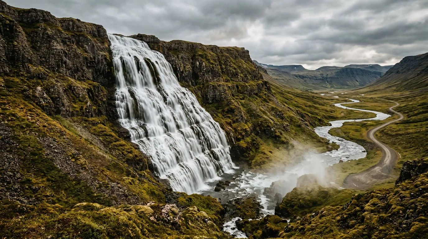
Dynjandi
The descent from Hrafnseyrarheioi delivers you to the base of Dynjandi, and the waterfall earns every superlative that the tourist board deploys. A hundred meters of cascading water, widening as it falls, spreading across a basalt cliff face like a bridal veil designed by someone with a more generous sense of scale. The walk to the base takes twenty minutes from the parking area and passes several smaller cascades on the way up.
Allow at least an hour here. The light changes constantly, the spray creates shifting rainbows, and the sound of falling water fills the fjord valley with a low roar that you feel in your chest. We have been to Dynjandi three times and have not yet managed to leave in under ninety minutes.
Dynjandisheioi to Bildudalur
Beyond Dynjandi, Route 60 climbs again over Dynjandisheioi — a shorter, rougher pass with worse gravel and a view back toward the waterfall that almost compensates for the vibration transmitted through the steering wheel. The descent from this second pass leads to the southern fjords and eventually to Bildudalur.
Bildudalur has fuel, a guesthouse, and the Icelandic Sea Monster Museum (Skrimslasetur), which is exactly as eccentric as it sounds and makes a better evening activity than you might expect. Accommodation options are limited — book ahead or carry camping equipment.
Day 2: Bildudalur to Patreksfjordur via Latrabjarg
| Distance: 140km | Drive time: 5-6 hours | Surface: Gravel dominant, poor in places |
This is the longest day in driving time because the roads to Latrabjarg are genuinely poor and the destination demands an extended stay. Leave Bildudalur heading west on Route 63.
The road to Latrabjarg
Route 612 branches south toward Latrabjarg, Europe’s westernmost point. This road is gravel throughout, single-lane for most of its length, and deteriorates progressively as you approach the cape. The last ten kilometers feature potholes that would be considered infrastructure failures in most countries but are considered normal in the Westfjords.
Latrabjarg itself is a bird cliff — twelve kilometers of vertical basalt wall that hosts millions of nesting seabirds, including puffins at conversational distance. From June through mid-August, you can lie on your stomach at the cliff edge and photograph puffins from less than a meter away. They are entirely unafraid of humans, possibly because they have met so few.
The cliff drops 440 meters to the ocean. There is no fence, no rail, no barrier of any kind between you and a vertical fall that would give you approximately nine seconds to contemplate your choices. Exercise appropriate caution, particularly in wind.
Rauoisandur
On the return from Latrabjarg, detour to Rauoisandur — a beach of red-gold sand that stretches for several kilometers along the coast. In a country of black volcanic beaches, Rauoisandur is startling. The sand gets its color from pulverized scallop shells, and in low afternoon light, the beach glows. You will want to stop. You should.
Patreksfjordur
Continue north to Patreksfjordur, the second-largest settlement in the Westfjords (population: approximately 700). The town has fuel, a supermarket, several guesthouses, and a swimming pool with a hot tub. After two days of gravel driving, the hot tub is not optional — it is medical treatment for your lower back.
Day 3: Patreksfjordur to Reykholar
| Distance: 110km | Drive time: 3-4 hours | Surface: Improving gravel and asphalt |
The shortest driving day, by design. After two days of concentrated gravel, the body and the car both appreciate a gentler pace.
Route 62 south
Leave Patreksfjordur on Route 62, which follows the coast southward toward the isthmus. The road improves steadily as you leave the Westfjords proper, transitioning from gravel to patched asphalt to genuine two-lane road. The landscape softens too — the severe fjord-and-mountain scenery gives way to rolling hills and sheltered bays.
Flokalundur hot pot
At Flokalundur, stop at the natural hot spring near the hotel. It sits on the shoreline with views across Vatnsfjordur, and the temperature is perfect — hot enough to ease the stiffness from two days of gravel driving, cool enough that you do not need to ration your time. Free, accessible, and usually empty.
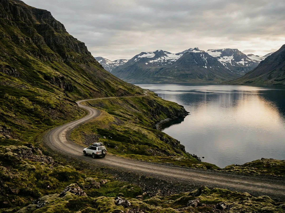
Breidafjordur islands
The road along the southern coast passes above Breidafjordur, the broad fjord separating the Westfjords from the Snaefellsnes peninsula. On a clear day, the view takes in thousands of islands scattered across the water like crumbs from a geological table. Stop at any of the viewpoints along Route 607 for the panorama.
Reykholar
Reykholar is a village on the southern coast with basic accommodation and the peculiar distinction of harvesting seaweed commercially. It is a quiet overnight stop — peaceful, unremarkable, and exactly what you need between the dramatic Westfjords and the drive back to Isafjordur.
Day 4: Reykholar to Isafjordur via the northern route
| Distance: 120km | Drive time: 3-4 hours | Surface: Mixed, gravel on passes |
The final day reverses the approach route, climbing back over the passes toward Isafjordur. If the weather cooperates, this is the day to stop at viewpoints you drove past on Day 1, when you were too focused on the unfamiliar gravel to appreciate the scenery.
Return over the passes
The road north on Route 60 crosses the same passes you traversed on Day 1, but the perspective is different heading north. The fjords that were ahead of you are now behind, and the mountain summits that were obscured by climbing angles are now visible from the approaching side.
If the weather on Day 1 was poor — and statistically, it probably was — this return transit may give you the clear-sky version of the same passes. The Westfjords often deliver their best weather in late morning, so timing the pass crossings for 10 AM to noon maximizes your chances.
The Dyrafjordur coast
Before the final tunnel approach to Isafjordur, the road follows the shore of Dyrafjordur. This is a beautiful stretch of coastal driving on a road that, by Westfjords standards, qualifies as excellent. The fjord is steep-walled and narrow, the water changes color with the light, and the small farms along the shore give the landscape a human scale that the highland passes lack.
Return to Isafjordur
Arrive back in Isafjordur through the Vestfjaroagong tunnel, completing the loop. We recommend a final meal at Tjoruhusio, the fish restaurant in a converted timber warehouse on the harbor. It serves whatever was caught that day, prepared simply, and it is one of the best meals in Iceland. You will have earned it.
Which car to rent
The Westfjords Circuit is not an F-road route, but 4WD is effectively mandatory. The gravel passes, the exposed ridges, and the Latrabjarg road all demand ground clearance and traction that a standard hatchback cannot provide.
| Vehicle | Verdict |
|---|---|
| Standard hatchback (i20, Yaris) | No. The gravel will terrify you and the car. |
| Small crossover (Duster, Tucson) | Minimum viable vehicle. Adequate in good weather. Stressful in rain. |
| Mid-size SUV (RAV4, Forester) | Good balance of capability and comfort. Our recommendation. |
| Full-size 4WD (Land Cruiser, Defender) | Overkill for this route but confidence-inspiring. |
| Campervan | Possible but stressful on narrow sections. Not recommended for Latrabjarg road. |
Check your rental agreement carefully. Some agencies prohibit specific routes in the Westfjords even in 4WD vehicles. The Latrabjarg road (Route 612) is the most commonly restricted.
For more on Iceland’s vehicle restrictions and highland driving requirements, see our Highland Roads Guide.
Practical information
| Detail | Information |
|---|---|
| Total distance | Approximately 500km loop |
| Total drive time | 15-19 hours across four days |
| Best months | July-August for best conditions and puffin season at Latrabjarg |
| Fuel planning | Fill at every opportunity. Gaps of 100+ km between stations. |
| Accommodation | Book ahead Jul-Aug. Options limited outside Isafjordur and Patreksfjordur. |
| Mobile coverage | Spotty outside towns. Absent on passes. Carry satellite communicator. |
| Ferry option | Baldur ferry (Stykkisholmur-Brjanslaekur) can shorten approach or create a one-way route |
| Emergency number | 112. Download the 112 Iceland app (sends GPS location with call). |
| Camping | Wild camping permitted in Iceland. Designated sites in Isafjordur and Patreksfjordur have facilities. |
Individual pass guides
For detailed kilometer-by-kilometer coverage of the mountain passes on this route, see our Westfjords Passes guide, which covers all the heath crossings along Routes 60 and 63.
Four days in the Westfjords changes your calibration. Roads you would have considered challenging at the start of the circuit feel routine by the end. Gravel that made you nervous on Day 1 barely registers on Day 4. The landscape does something similar — by the time you drive back into Isafjordur, the mountains and fjords that amazed you on departure feel almost familiar. Almost. Then you look at your photographs and realize that nothing about this place should ever feel ordinary.