Westfjords Passes
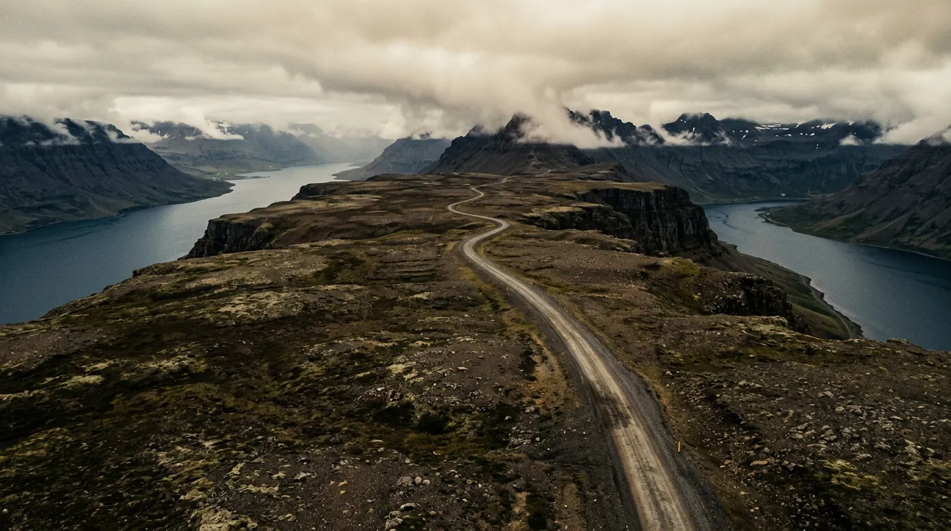
You are forty minutes into a gravel road that your rental agency specifically asked you not to drive, the fog has dropped to the point where you can see exactly one car length ahead, and the GPS shows nothing but a blue squiggle tracing the edge of a fjord that you cannot see but can absolutely hear. Then the cloud lifts for thirty seconds and you get a glimpse of what you came for — a mountainside dropping vertically into water so still it looks like poured mercury, a road scratched across the cliff face ahead of you like someone attacked the landscape with a chisel, and not a single other human being anywhere in the frame. This is the Westfjords. This is the driving that Iceland does not put on the tourist brochures.
Why drive the Westfjords passes
The Westfjords are Iceland’s forgotten limb — a claw of peninsulas jutting northwest from the main island, connected to the rest of the country by a single narrow isthmus. Ninety-five percent of Iceland’s tourists never come here. The Ring Road, that comfortable loop of asphalt that most visitors follow, does not touch the Westfjords. Getting here requires commitment: either a long detour on gravel roads or a ferry from Stykkisholmur. The reward for that commitment is the most dramatic coastal mountain driving in northern Europe.
The passes themselves are not high by Alpine standards. The summits along Routes 60 and 63 top out around 500-600 meters. But altitude is not the point. These passes gain their difficulty from surface conditions, exposure, weather, and isolation. The roads are predominantly gravel — compacted and reasonable in dry weather, loose and unpredictable in rain. They are single-lane for long stretches, with passing places that require both drivers to have functioning depth perception and a willingness to reverse. And they traverse some of the most exposed coastal terrain in Iceland, where the wind does not gust so much as maintain a steady lateral force that requires constant steering correction.
What makes these passes special is not any single element but the accumulation: the quality of light on the fjords, the emptiness of the landscape, the sense of driving somewhere that civilization has only partially claimed. The Highland Roads get the reputation for extreme driving in Iceland, but the Westfjords passes deliver genuine remoteness on roads that do not require fording rivers or owning a modified Land Cruiser.
Which direction to drive
North to south, starting from Isafjordur.
The logic is practical. Isafjordur is the only town in the Westfjords with reliable fuel, accommodation, a supermarket, and a hospital. Starting here means you begin each day from a position of resupply and end each day moving toward the next fuel stop. Driving south-to-north means committing to the most remote sections first, with no guarantee of fuel or assistance if something goes wrong.
There is also an aesthetic argument. Driving southward, the fjords open ahead of you. The passes climb from the coast, crest their summits, and drop into the next fjord with the water visible below. Heading north, you spend more time looking at the mountainside you are climbing rather than the seascape you are approaching. The difference is real and it matters on a drive where the scenery is, quite literally, the entire point.
If you are including the Westfjords Circuit, plan Isafjordur as both your start and your finish. The town has earned the right to be called a base camp.
The passes of Route 60
Hrafnseyrarheioi
The first significant pass heading south from Isafjordur crosses Hrafnseyrarheioi, a heath plateau at roughly 500 meters. The road climbs from the shore of Dyrafjordur in a series of gravel switchbacks that would be unremarkable in most countries but feel significant in Iceland, where the combination of loose surface and wind exposure makes every turn a small negotiation.
The summit is flat and featureless — a plateau of moss and rock where visibility can drop to near zero when the fog rolls in, which it does with a regularity that suggests personal intent. In clear weather, the views from the top take in multiple fjords simultaneously, a panorama that makes the gravel rattle against your wheel arches feel worthwhile.
The descent toward Dynjandi is where this pass earns its difficulty rating. The road drops steeply toward the coast on a surface that transitions from compacted gravel to something more closely resembling a suggestion. In wet conditions, the final kilometer before the coast requires genuine care.
We drove Hrafnseyrarheioi in horizontal rain and saw nothing from the summit except the inside of a cloud. We drove it again two days later in sunshine and could see three fjords, two waterfalls, and the distant outline of the Hornstrandir cliffs. Same road, entirely different experience. Iceland does not reward rigid scheduling.
Dynjandisheioi
South of Dynjandi — itself a waterfall so spectacular that it justifies the entire drive — the road climbs again over Dynjandisheioi. This pass is shorter and lower than Hrafnseyrarheioi, but the road quality deteriorates noticeably. The gravel is looser, the passing places fewer, and the surface has a tendency to develop washboard corrugation that vibrates through the car at exactly the frequency that makes your fillings ache.
The compensation is the view back toward Dynjandi from the summit. The waterfall appears as a white streak against dark rock, framed by the V-shape of the fjord. This is one of the most photographed compositions in the Westfjords, and for once, the photographs are not lying.
The passes of Route 63
Route 63 runs along the southern shore of the Westfjords, connecting Bildudalur to the isthmus that links the region to mainland Iceland. This road is newer and in marginally better condition than Route 60, but it still includes two significant passes that demand attention.
Kleifaheioi
The pass between Talknafjordur and Bildudalur crosses Kleifaheioi at approximately 400 meters. By Westfjords standards, this is a gentle pass — the gradient is moderate, the road is two-lane asphalt for most of its length, and there are actual guardrails in the more exposed sections. Consider it a warm-up or a cool-down, depending on your itinerary direction.
The interest here is geological rather than technical. The pass cuts through layers of basalt that have been eroded into horizontal striations, giving the mountainside the appearance of a badly printed barcode. In late evening light, these layers catch the sun at different angles and the entire mountain turns into a study in brown, orange, and purple.
Geirshjukur ridge road
The stretch of Route 63 between Bildudalur and Patreksfjordur traverses a ridge at roughly 500 meters that is not technically a named pass but drives like one. The road here is exposed to the full force of North Atlantic weather, and the wind can be extraordinary. We experienced a gust on this section that moved the car a full lane width sideways. The steering wheel became a suggestion rather than an instruction.
This is single-lane gravel with passing places, and if you meet an oncoming vehicle on the ridge, one of you is reversing on loose surface with a crosswind. The protocol is that the uphill vehicle yields, but in practice, the protocol is that whoever has the smaller car and the more flexible ego reverses first.
Kilometer by kilometer: Route 60 south from Isafjordur
Km 0-15: Isafjordur to Dyrafjordur shore
The road leaves Isafjordur through a single-lane tunnel — the Vestfjaroagong, which is one-way with timed traffic lights and an unnerving interior junction. Emerge on the southern side and the road follows the shore of Onundarfjordur on decent asphalt. Enjoy the pavement. It becomes scarce.
At the head of Dyrafjordur, the road turns to gravel and begins the approach to the first pass. Fuel up in Isafjordur — there is nothing ahead for 120 kilometers.
Km 15-35: The first pass and Dynjandi
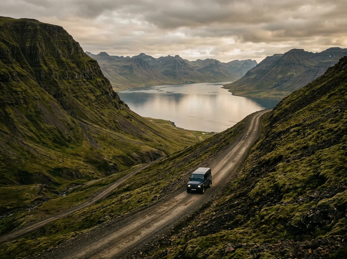
The climb to Hrafnseyrarheioi begins abruptly. The road turns away from the fjord and switchbacks up the mountainside on loose gravel. The gradient reaches 12% in places, and in a two-wheel-drive vehicle, wheelspin on the steeper bends is a real possibility. This is why we say AWD is needed.
The summit plateau stretches for about three kilometers — flat, exposed, and frequently foggy. Then the descent begins toward the coast, dropping steeply to the stunning Dynjandi waterfall. Allow at least forty-five minutes at Dynjandi. The waterfall is 100 meters of cascading water that widens as it falls, and the walk to the base takes twenty minutes each way.
Km 35-60: Dynjandisheioi and the southern shore
Beyond Dynjandi, the road climbs again over Dynjandisheioi. This pass is shorter but rougher. The gravel here is the worst on Route 60 — large loose stones that reduce your speed to 20-30 km/h regardless of your ambitions. The descent to the southern fjords brings a gradual improvement in road surface and, eventually, patched asphalt.
Km 60-85: Approach to Bildudalur
The final section follows the southern shore through a landscape that transitions from austere plateau to coastal — fishing villages appear, the road improves, and you begin to feel like civilization is a thing that still exists. Bildudalur has a fuel station and a peculiar museum about sea monsters. Both are useful stops.
Practical information
| Detail | Information |
|---|---|
| Opening dates | Routes 60/63 are typically passable mid-June to late September, weather dependent |
| Toll | None — all Westfjords roads are free |
| Fuel | Isafjordur (reliable), Bildudalur (limited hours), Patreksfjordur (reliable). Nothing between passes. |
| Parking | Pull-offs at Dynjandi waterfall, pass summits, and fjord viewpoints. No formal lots. |
| Best time | July-August for best road conditions and longest daylight. September for emptiest roads. |
| Avoid | Early June (snow/ice on summits), late September (deteriorating conditions), any day with storm warnings |
| Drive time | Isafjordur to Bildudalur via Route 60: 3-4 hours without stops, 5-6 with photography and Dynjandi |
| Rental restrictions | Most agencies prohibit standard cars on Route 60 gravel sections. Verify your contract. |
| Emergency | No mobile coverage on many pass sections. Carry a satellite communicator or PLB. |
Weather and conditions
The Westfjords generate their own weather. A forecast for Reykjavik is irrelevant here. The Icelandic Met Office (vedur.is) provides specific Westfjords forecasts, and checking them each morning is not optional — it is the first task of the day, before coffee, before breakfast, before any driving plans are confirmed.
| Condition | Impact |
|---|---|
| Fog | Common on summits Jun-Sep. Reduces visibility to 10-20m. Slow to walking pace. |
| Wind | Sustained 50-70 km/h is normal. Gusts over 100 km/h close roads. Check road.is. |
| Rain | Turns gravel to mud. Reduces grip significantly. Extends drive times by 30-50%. |
| Snow | Possible on summits in June and September. Brief but disorienting. |
| Sunshine | Rare and spectacular. If it happens, abandon all plans and drive immediately. |
Combine with nearby routes
The Westfjords passes are best experienced as part of the Westfjords Circuit, a four-day loop that covers the entire northwest peninsula. The circuit includes these passes plus the coastal roads of Latrabjarg (Europe’s westernmost point) and the Strandir coast.
For context on Iceland’s road classification system — F-roads versus numbered routes, which vehicles are permitted where, and the perennial question of river crossings — see our Highland Roads Guide. The Westfjords passes are not F-roads, but they share some of the same challenges: loose surface, isolation, and weather that treats your schedule as a theoretical document.
The Westfjords are the antithesis of the Ring Road. No tour buses, no Instagram crowds, no reassuring queue of rental cars ahead of you confirming that the road is passable. Out here, you are making your own decisions based on your own assessment of conditions. That is either the worst possible description of a holiday or the best one, and we know which side of that divide we fall on.