Mangrt Road
The Mangrt Road does not go anywhere. It climbs from a junction on the Predel Pass road to the Mangrt Saddle at 2,055 meters and stops. Dead end. The road exists because the Italian military built it in the 1930s to access an observation post overlooking the Yugoslav border, and when the geopolitical reason for the road evaporated, the road itself remained — a twelve-kilometer ascent to nothing except altitude, exposure, and one of the most extraordinary views in the Julian Alps.
We need to be direct about the Mangrt: this is the most demanding road on SteepPass that is not gravel. The upper five kilometers are single-lane with no passing places. Two of the tunnels were carved from the mountainside with no lighting, no lining, and barely enough width for a single car. The road edge, on the sections that are not walled by tunnel rock, drops away to nothing. There is no destination at the top except a parking area, a hiking trailhead, and the view. You drive up and you drive back down, on the same road, and if you meet someone coming the other direction in the tunnels, one of you is reversing blind through a rock tube until you find enough width to pass.
This is not a criticism. It is a description. And if that description sounds appealing rather than alarming, the Mangrt Road is for you.
Why drive Mangrt Road
The Mangrt (2,679m) is the third-highest peak in Slovenia, and the Mangrt Road reaches its saddle at 2,055 meters — the highest point accessible by road in the country. The road is not famous. It does not appear in most driving guides, most travel itineraries, or most rental car insurance policies. This anonymity is part of its value.
What the Mangrt delivers is genuine mountain driving in the purest sense. No gift shop. No summit restaurant. No toll booth. No tour buses — the tunnels physically prevent them. Just a narrow road climbing through increasingly dramatic terrain to a point where you are above most of the surrounding landscape, looking out over the Julian Alps with the Adriatic haze visible to the south and the Austrian Alps to the north.
The road was built for military observation, and the military chose the location well. From the Mangrt Saddle, visibility on a clear day extends to the Dolomites to the west, the Karawanken range to the north, and the Slovenian coast to the south. The panorama is, by any honest accounting, one of the best accessible by car in the Alps.
But the drive is the thing. The progression from comfortable two-lane road to single-lane mountain track, from asphalt through tunnel through gravel to the exposed summit parking area, creates a narrative of increasing commitment. Each kilometer higher reduces your margin. There is no bail-out point above the tunnels — once you are through them, the only way back is through them again. This concentrates the mind in a way that wider, more forgiving passes do not.
The approach
The Mangrt Road begins at a junction on the road between Log pod Mangartom and the Predel Pass (the Italian border crossing). The junction is signed, though not prominently. From Bovec, the drive to the junction is about 20 minutes on a good two-lane road that follows the Koritnica valley.
At the junction, the road immediately begins to climb. The first three kilometers are two-lane asphalt in reasonable condition, climbing through mixed forest with moderate hairpins. This section is misleading. It suggests that the Mangrt Road is a normal mountain road. It is not. The normalcy ends at approximately 1,400 meters.
Kilometer by kilometer
Km 0-3: The deceptive introduction
From the junction at roughly 900 meters, the road climbs through forest on two-lane asphalt. Three hairpins, well-surfaced, good visibility. You might think: this is fine, what was everyone worried about? File that thought under “premature conclusions.”
The gradient is moderate, around 8%. The forest is dense spruce and beech, filtering the light. Traffic is sparse even in summer — the Mangrt’s reputation precedes it, and most drivers who start the approach have done their research. This is not a road that attracts casual tourists.
Km 3-5: The narrowing
Above 1,400 meters, the road narrows from two lanes to one and a half, then to one. The asphalt surface begins to show its age — patches, cracks, sections where frost heave has created undulations. The forest thins, and the mountainside becomes visible above and below the road.
The first pull-off appears — a widened section of road that allows two cars to pass. These pull-offs are your lifeline for the next seven kilometers. Memorize their locations on the way up, because you will need them on the way down.
The gradient steepens to 10-12%. In a low-powered car, second gear becomes first gear. The temperature drops.
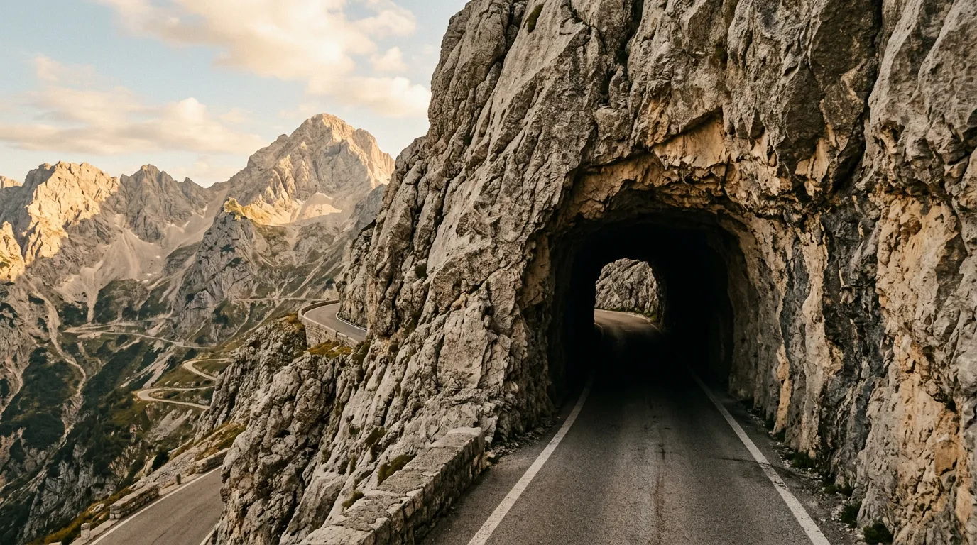
Km 5-7: The tunnels
The tunnels are the Mangrt Road’s defining feature and its primary source of anxiety. There are several, but two are significant:
Tunnel 1 is approximately 100 meters long, unlined, unlit, and barely wider than a car. The rock walls are rough-cut — you can see the drill marks from the original Italian military construction. There is no room to pass an oncoming vehicle. If you meet someone, one of you reverses out. There is no protocol for who reverses — it is determined by who is closest to an exit and who has the better reverse-gear skills.
Enter slowly. Turn on headlights before entering, not after. Sound your horn at the entrance. If you hear a horn or see headlights from the other end, stop and wait.
Tunnel 2 is shorter but curved, meaning you cannot see the exit from the entrance. The curve is gentle enough that you will not lose your bearings, but the combination of darkness, rough rock walls, and blindness to what is ahead creates a specific intensity that we will diplomatically describe as “character-building.”
Between and after the tunnels, the road clings to the mountainside on a ledge that was blasted from the rock. The drop on the outside is real — several hundred meters to the valley floor, with guardrails that are either token or absent. This is the section that earns the difficulty 4 rating.
Km 7-10: The exposed traverse
Above the tunnels, the road traverses an exposed mountainside with the Julian Alps panorama opening progressively. The surface deteriorates — patches of asphalt alternate with gravel sections, and loose stones from the cliff face above litter the road.
This section has the least protection and the most exposure. The road is single-lane, the drop on the outside is precipitous, and the guardrail — where it exists — consists of wooden posts with steel cable that would stop a bicycle but not a car. Drive on the mountain side of the road. Keep speed below 20 km/h. Do not look at the drop while driving. Look at it while stopped.
Two more hairpins navigate the upper traverse. These are tight — full-lock turns on loose surface with a drop on the outside. The inside edge is rock wall. Threading a standard car through these turns requires spatial awareness and patience.
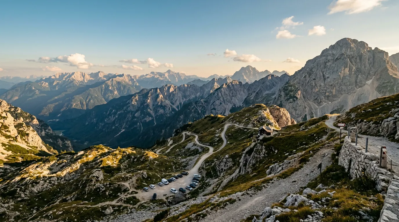
Km 10-12: The Mangrt Saddle
The final two kilometers ease slightly as the road approaches the saddle. The gradient lessens, the surface stabilizes, and a small parking area appears at 2,055 meters. You have arrived.
The parking area holds perhaps fifteen cars. A hiking trail leads from here to the Mangrt summit (2,679m, approximately 3-4 hours return for experienced hikers). A mountain hut (Koca na Mangrtskem sedlu) operates in summer, serving drinks and basic food. The views are extraordinary in every direction.
Park. Breathe. Consider the fact that you need to drive this road back down.
The descent
The descent is harder than the ascent. This is true of most mountain roads, but on the Mangrt it is especially true because the sections that were demanding on the way up become more demanding when your relationship with gravity is reversed.
The tunnels, in particular, are more stressful in descent. You are braking on an uncertain surface in darkness, and if you meet an uphill vehicle, you are the one who should reverse — uphill reversing is the established (if informal) convention, because the uphill vehicle has better visibility and more control.
Allow 45-60 minutes for the descent. Do not rush. The road has existed since the 1930s and will continue to exist after you leave. Take the time to descend smoothly, and stop at the pull-offs to let the brakes cool.
The first tunnel is the test. If you enter it, see the rough rock walls closing to within centimeters of your mirrors, feel the darkness and the slight uphill gradient, and think “this is excellent” — you will love the Mangrt Road. If you enter it and think “this was a mistake” — reverse out, no shame, and drive the Vrsic instead. The Vrsic has fifty hairpins and a gift shop. The Mangrt has rock tunnels and a parking lot. Both are Julian Alps driving. They are not the same thing.
Practical information
| Detail | Information |
|---|---|
| Opening dates | Typically mid-June to mid-October, snow and rockfall dependent |
| Toll | Small fee (approximately 5 EUR) collected at the junction barrier in summer |
| Fuel | No fuel on road. Last fuel: Bovec (20 minutes from junction) or Log pod Mangartom |
| Parking | Small lot at Mangrt Saddle (free with toll payment). No parking in tunnels (obviously). |
| Best time of day | Morning for clearest conditions and fewest oncoming vehicles |
| Avoid | Weekends in July-August (increased traffic = more tunnel encounters). Rain (slippery surface + reduced visibility). |
| Length | 12km from junction to Mangrt Saddle |
| Drive time | 40-50 minutes up, 45-60 minutes down |
| Vehicle restrictions | No vehicles wider than 2.0m. No vehicles longer than 8m. No caravans, no trailers, no buses. |
Vehicle considerations
| Factor | Detail |
|---|---|
| Width | Critical. The tunnels have approximately 2.5m clearance. A standard car (1.7-1.8m) fits with margin. A wide SUV (1.9m+) fits but you will be aware of every centimeter. |
| Mirrors | Fold them. Seriously. Fold your mirrors before the tunnels. |
| Ground clearance | Standard is adequate for the paved sections. The gravel sections near the summit benefit from slightly higher clearance. |
| Power | Moderate gradient — any car with 90+ HP is fine. The difficulty is not the gradient; it is the width and the surface. |
| Brakes | Must be in good condition. The descent is sustained and the surface reduces braking efficiency. Check pads before attempting. |
Combine with nearby drives
Mangrt + Vrsic: The essential Julian Alps pair. Drive the Vrsic Pass north-to-south (50 numbered hairpins, cobblestones, 1,611m), overnight in Bovec, then tackle the Mangrt the next morning. The contrast in character — Vrsic is a through-route with traffic and infrastructure; Mangrt is a dead-end with tunnels and solitude — makes the combination deeply satisfying.
Mangrt + Predel: The Predel Pass (1,156m) crosses into Italy from the same valley that leads to the Mangrt junction. It is a gentle, scenic border crossing that makes a pleasant afternoon drive after the intensity of the Mangrt.
Julian Alps Pass Loop: The full circuit chains Vrsic, Mangrt, and Predel into a two-day loop with Bovec at the center. It is compact, varied, and contains more driving drama per kilometer than any comparable route in the Alps.
We drove the Mangrt on a September morning with exactly three other vehicles on the road. Two were hikers heading for the summit trail. One was a motorcyclist from Vienna who stopped at the second tunnel, assessed the width, and turned around. We met him at the junction two hours later and he explained, quite reasonably, that his motorcycle’s handlebars were wider than a car’s mirrors and the tunnel margins were unacceptable. He was right. We did not tell him about the second tunnel, the curved one. Some information is better delivered after the experience rather than before.