Eastern Turkey Pass Expedition
Somewhere on the second day of this expedition — probably on the exposed hairpins above 2,400 meters on the Ovit, where the road narrows to a suggestion and the Kackar peaks fill the windscreen — it will occur to you that this is not an itinerary you saw recommended on any travel website, in any guidebook, or by any rental agency. There is a reason for that. Eastern Turkey’s mountain passes are not hidden gems waiting to be discovered by the content marketing industry. They are fully visible, well-documented, entirely accessible, and almost completely ignored by anyone who is not Turkish, not a truck driver, and not the kind of person who considers “there might be no one to help if something goes wrong” a feature rather than a warning.
We are those people. This expedition chains three mountain passes across the Pontic Alps and the western Anatolian highlands into a five-day driving route that covers 600 kilometers and crosses from the humid Black Sea coast to the dry continental interior. It is not extreme. It is not dangerous. It is, however, genuinely adventurous in the original sense of the word: you will drive roads where English signage is absent, where your car will be the only non-local vehicle for hours at a stretch, and where the landscapes are so far outside the European driving mainstream that they feel like they belong to a different continent.
They do, technically. But that is a geographic argument for another time.
Route overview
The expedition starts in Trabzon on the Black Sea coast and traces a westward arc through the Pontic Mountains and the Anatolian highlands, linking three major passes:
| Day | Route | Pass | Elevation | Distance | Drive time |
|---|---|---|---|---|---|
| 1 | Trabzon — Torul | Zigana Pass | 2,032m | 95km | 3-4 hours |
| 2 | Torul — Ikizdere — Ispir | Ovit Pass | 2,640m | 140km | 5-6 hours |
| 3 | Ispir — Erzincan | Transfer day | — | 180km | 3-4 hours |
| 4 | Erzincan — Kastamonu | Ilgaz Pass | 2,000m | 120km | 4-5 hours |
| 5 | Kastamonu — buffer/return | — | — | Variable | Variable |
Total: approximately 600km and 18-22 hours of mountain driving across five days. The distances are not long by Turkish standards, but the roads are slow, the scenery demands stops, and rushing this route defeats the purpose of driving it.
Getting started: Trabzon
Trabzon is the logical starting point. The city has an international airport with direct flights from Istanbul (multiple daily, ~90 minutes), a functioning car rental market, and a historical significance that provides context for the journey ahead.
Car rental
Rent in Trabzon, return in Trabzon (or negotiate a one-way drop at significant surcharge). The major international agencies are present at the airport — Europcar, Avis, Budget — and there are several reliable local agencies on the airport approach road. Local agencies typically offer better rates and more flexible policies.
| Vehicle type | Suitability |
|---|---|
| Small hatchback (Fiat Egea, Renault Clio) | Possible but underpowered on Ovit gradients. Not recommended. |
| Compact sedan (Corolla, Civic) | Adequate. Sufficient power for all three passes. Ground clearance limiting if you detour. |
| Compact SUV (Tucson, Kiger, Duster) | Recommended. Better ground clearance for summit road deterioration. |
| Full-size SUV | Unnecessary. All three passes are paved. |
Manual transmission is significantly cheaper and widely available. If you are comfortable with a manual on mountain roads, the savings are worth it — and the engine braking on descents is a genuine advantage.
Day 1: Trabzon to Torul via Zigana Pass
| Distance: 95km | Drive time: 3-4 hours | Pass: Zigana, 2,032m |
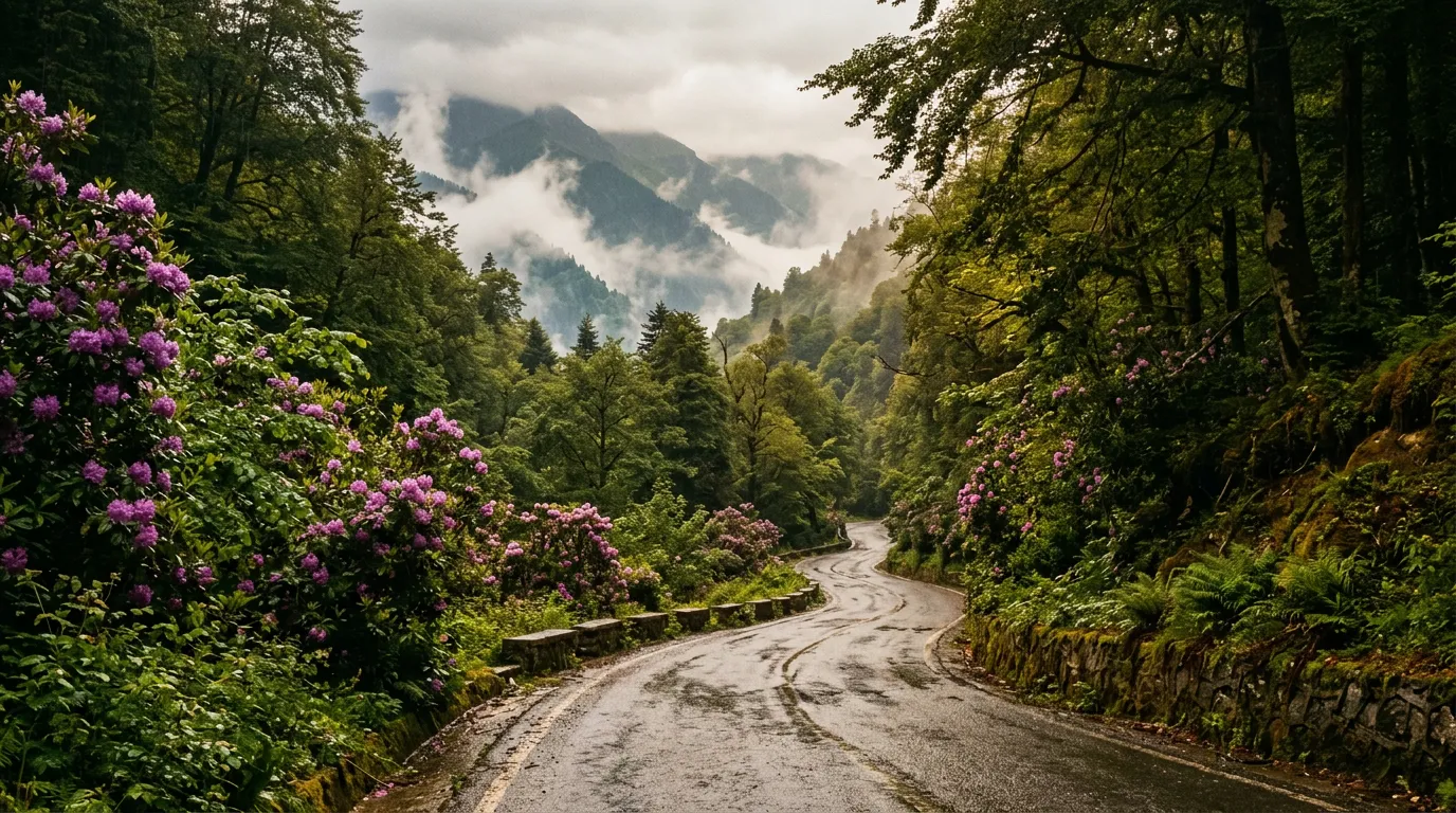
Leave Trabzon in the morning after fuel and provisions. The Zigana Pass is your introduction to Turkish mountain driving — a well-maintained, moderate-difficulty pass that crosses the Pontic Alps from the humid Black Sea coast to the dry interior.
The approach
Follow the main highway south from Trabzon toward Gumushane. At the junction for the Zigana Tunnel, take the old road (right fork, signed “Zigana Gecidi”). The GPS will route you through the tunnel. Override it.
The crossing
The Zigana climbs 20 kilometers through tea plantations, dense forest, and alpine meadow to a summit at 2,032 meters. The road is well-engineered, two lanes throughout, with good guardrails on the exposed sections. Fourteen hairpins provide a rhythm that is engaging without being stressful.
The transition from north to south is the highlight. You enter the pass in Black Sea humidity, surrounded by lush vegetation and the scent of tea. You exit in the dry air of the Anatolian interior, surrounded by brown grass and scattered pines. Twenty kilometers, two continents.
Overnight: Torul or Gumushane
Torul is a small town in the Harsit valley between the Zigana and the next day’s drive. It has basic accommodation, fuel, and a spectacular medieval castle ruin perched on a cliff above the river. Gumushane, slightly further south, has more accommodation options and a functioning town center. Either works as an overnight stop.
Day 2: Torul to Ispir via Ovit Pass
| Distance: 140km | Drive time: 5-6 hours | Pass: Ovit, 2,640m |
This is the expedition’s centerpiece. The longest day, the highest pass, and the most dramatic driving.
The connecting drive
From Torul, head northeast on the main highway toward Trabzon, then branch east along the coast road to Ikizdere. This connecting section follows the Black Sea coast through a landscape of hazelnut orchards, tea plantations, and small fishing towns. The road is good but busy — this is a main highway, and trucks are frequent. Allow 90 minutes for this section.
Ikizdere to Ovit summit
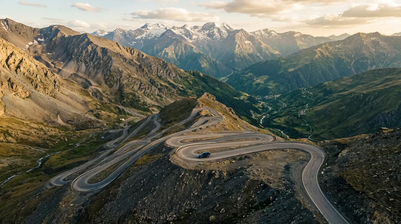
At Ikizdere, leave the coastal highway and climb south on the old Ovit road. The next 30 kilometers are detailed in our Ovit Pass guide, but the summary: you gain nearly 2,000 meters of elevation through four distinct climate zones, from tea country through dense forest to alpine meadow to high-altitude rock. Twenty-two hairpins. Almost no traffic since the tunnel opened. The views from the upper hairpins are among the best mountain driving scenery we have encountered anywhere.
Take the old pass road, not the tunnel. We cannot emphasize this enough. The tunnel saves ninety minutes. Those ninety minutes contain the best driving on this expedition.
Ovit summit to Ispir
The descent from the Ovit’s 2,640-meter summit drops into the Coruh valley through dry, austere terrain that contrasts sharply with the lush northern approach. The road is good, the gradient moderate, and the landscape fascinating in its barrenness. Ispir, at roughly 1,300 meters, is a small town with basic accommodation and fuel.
Overnight: Ispir
Ispir is not a tourist town. Accommodation options are limited to a few small hotels and pensions. The town has fuel, a few restaurants, and a ruined castle. English is rare. This is the point on the expedition where you are furthest from any tourist infrastructure, and that is part of the appeal. Download a translation app before you leave Trabzon.
Day 3: Ispir to Erzincan (transfer day)
| Distance: 180km | Drive time: 3-4 hours | No pass |
A transfer day through the upper Coruh and Kelkit valleys. The driving is not dramatic — this is valley highway connecting two mountain segments — but the landscape has a severe, high-altitude beauty that rewards attention.
The route
Follow the highway west from Ispir through Bayburt (a small city with a large castle and a culinary specialty called “cag kebab” that you should try) and continue to Erzincan. The road follows river valleys for most of the distance, crossing elevated terrain between the Coruh and Kelkit watersheds but nothing that qualifies as a pass.
Erzincan
Erzincan is a mid-size city that serves as the expedition’s logistical checkpoint. Fuel up, resupply, rest. The city was leveled by earthquakes in 1939 and 1992 and rebuilt both times with the practicality that characterizes eastern Turkish urbanism. It is not charming, but it is functional, and after two days of mountain driving, functional has its merits.
The city’s Kemaliye district (formerly Egin), accessible via a spectacular canyon road, is worth a detour if you have an extra half-day. The canyon of the Euphrates upstream from Kemaliye is genuinely breathtaking, though the road is narrow and demanding.
Day 4: Erzincan to Kastamonu via Ilgaz Pass
| Distance: 120km approach + Ilgaz section | Drive time: 4-5 hours | Pass: Ilgaz, ~2,000m |
The final pass of the expedition crosses the Ilgaz range south of Kastamonu, linking the central Anatolian plateau with the western Pontic region.
The approach
The drive from Erzincan westward follows the main highway through a landscape of rolling plateau — agricultural land, small towns, the kind of road where you can set a comfortable speed and think about the passes behind you. This section covers the most distance with the least drama.
Ilgaz Pass
The Ilgaz Pass (Ilgaz Gecidi) crosses the Ilgaz Mountains at approximately 2,000 meters. It is less dramatic than the Ovit and less historically weighted than the Zigana, but it has its own character: dense forest on both sides, a well-maintained road with moderate hairpins, and a national park at the summit that provides the rare luxury (on this expedition) of an actual visitor center, actual toilets, and actual coffee.
The pass is one of the snowiest in Turkey, and the Ilgaz Ski Resort operates on its slopes in winter. In summer, the summit area is a cool, forested refuge from the heat of the lowlands — a pleasant contrast to the exposed summits of the Zigana and Ovit.
The descent into Kastamonu is gradual and forested, with the road unwinding through pine forest that extends for kilometers. The approach to Kastamonu itself is scenic — the town sits in a valley surrounded by wooded hills, with a castle on the ridge above.
Overnight: Kastamonu
Kastamonu is a genuine surprise. An Ottoman-era town with a well-preserved old quarter, a castle with panoramic views, and a food culture that includes a distinctive local pastry called “banduma.” Accommodation ranges from Ottoman-house conversions in the old quarter to modern hotels on the ring road. After four days in eastern Turkey’s sparse accommodation landscape, Kastamonu feels like a return to something approaching luxury.
Day 5: Buffer and return
Day 5 is deliberately unstructured. Options include:
Return to Trabzon via inland route (fastest). Approximately 500km, 7-8 hours on highway. Long but straightforward.
Fly from Kastamonu. The airport has limited flights to Istanbul. Check schedules.
Continue to Istanbul. Approximately 500km west on good highway, 5-6 hours.
Detour via Safranbolu. The UNESCO World Heritage Ottoman town is 90 minutes south of Kastamonu and worth a half-day. Then continue to Istanbul or Ankara.
Which car to rent
All three passes on this expedition are paved. You do not need 4WD. You do need a car with sufficient power to maintain momentum on sustained 10-12% gradients at altitude.
| Factor | Recommendation |
|---|---|
| Engine | 1.4L turbo petrol minimum. Naturally aspirated 1.0L will struggle at altitude. Diesel excellent for gradient. |
| Transmission | Manual preferred (engine braking on descents, lower rental cost). Automatic adequate. |
| Ground clearance | Standard is fine. Higher clearance useful for deteriorated summit sections. |
| Tires | All-season minimum. Check condition before departure — long distances on gravel shoulders. |
| Fuel capacity | Plan for 80-100km gaps between fuel stations on pass sections. |
Practical information
| Detail | Information |
|---|---|
| Total distance | ~600km over 5 days |
| Total drive time | 18-22 hours |
| Best months | June-September for all three passes open. May and October possible but check Ovit. |
| Fuel planning | Fill at every town. Maximum gap: ~100km (Ikizdere to Ispir via Ovit). |
| Language | Very little English outside Trabzon. Download Turkish offline on Google Translate. |
| Currency | Turkish lira. Card widely accepted in towns but carry cash for rural fuel and accommodation. |
| Mobile coverage | Turkcell has best mountain coverage. Spotty above 2,000m. Functional in all towns. |
| Road conditions | Check karayollari.gov.tr for pass closures, especially early/late season. |
| Speed enforcement | Turkey has speed cameras on highways. Follow limits. Mountain roads are self-enforcing. |
| Toll roads | Most of this route is toll-free. If you use the O-road (motorway) sections, you need an HGS sticker on the windshield — available from PTT post offices. |
Navigation
A note on navigation: Google Maps is functional but not always accurate in eastern Turkey. Mountain road routing sometimes suggests tracks that are not passable in a standard car. Waze is less used in the region. The most reliable approach is to download the Turkey offline map on Google Maps, confirm your route on the day of driving with a local (hotel staff are helpful), and accept that you may miss a turn and need to backtrack.
Road signs in Turkey are generally good on main roads and inconsistent on mountain passes. Signs use both Turkish and (sometimes) English. The key Turkish words for navigation:
| Turkish | English |
|---|---|
| Gecidi | Pass |
| Tuneli | Tunnel |
| Sag | Right |
| Sol | Left |
| Duz | Straight |
| Dikkat | Caution |
| Yavas | Slow |
Individual pass guides
Each pass on this expedition has a dedicated guide:
- Zigana Pass — ancient Silk Road crossing, 2,032m, difficulty 2
- Ovit Pass — Turkey’s highest paved pass, 2,640m, difficulty 3
This expedition is not for everyone. It requires comfort with unfamiliar situations, patience with language barriers, and the kind of self-reliance that comes from knowing that the nearest English-speaking mechanic may be four hours away. But if you have driven the Alps and found them too manicured, or the Balkans and found them too discovered, eastern Turkey’s mountain passes offer something increasingly rare in European driving: genuine remoteness on genuine roads, with no Instagram queue at the summit and no gift shop at the base. Just the road, the mountain, and the satisfying certainty that you chose to be here.