Ovit Pass
The new Ovit Tunnel opened in 2018. It is 14.3 kilometers of straight, illuminated, temperature-controlled engineering that bypasses the old pass road entirely. It takes twelve minutes. It is free. The GPS will route you through it automatically. We are here to tell you, with the conviction of people who have driven both options, that using the tunnel is a decision you will regret for the rest of your driving life.
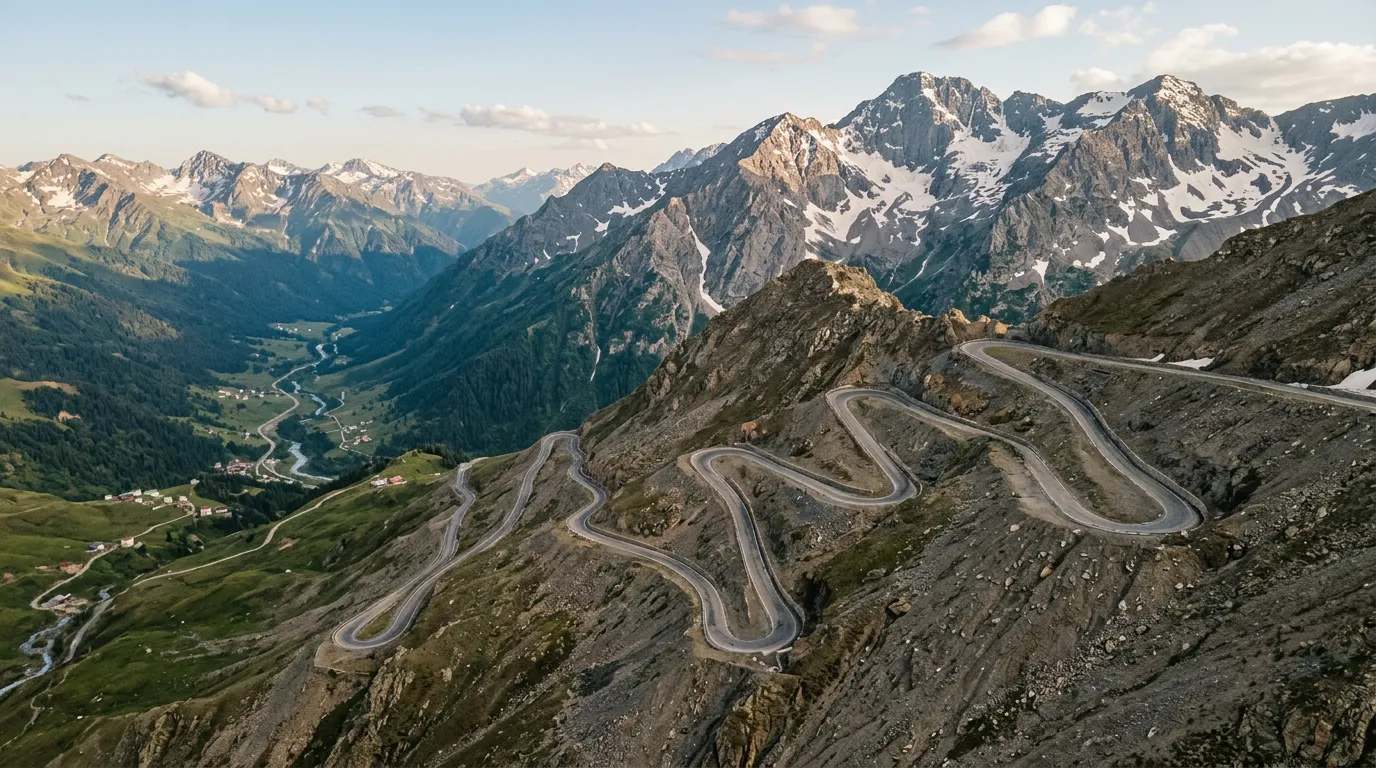
The old Ovit Pass road — the one the tunnel was built to replace — climbs to 2,640 meters through the Kackar Mountains in a sequence of twenty-two hairpins that gain nearly two thousand meters of elevation in thirty kilometers. It is Turkey’s highest paved road. It takes two hours instead of twelve minutes. It is the reason you drove to northeast Turkey.
Why drive Ovit Pass
The Kackar Mountains are the Eastern Alps that nobody talks about. A granite spine running parallel to the Black Sea coast, topping out above 3,900 meters, with glacial valleys, alpine meadows, and a tree line that delivers some of the most dramatic elevation transitions in Europe (or western Asia, depending on your geographic taxonomy, which we are not here to settle).
The Ovit Pass crosses the Kackar range at its most dramatic point. The northern approach starts in the humid, tea-growing lowlands above Ikizdere at roughly 700 meters. Over the next thirty kilometers, you climb through dense forest, break above the tree line into alpine meadow, navigate a series of tight hairpins across a barren rock face, and arrive at a summit that sits higher than most ski resorts. The descent on the southern side drops into the Coruh River valley — dry, austere, and geologically distinct from the lush north side.
The elevation change is the story. In most Alpine passes, you gain 800-1,200 meters over the course of the climb. The Ovit gains close to two thousand. The temperature at the base may be 28 degrees Celsius. At the summit, it will be 8. You will drive through four distinct climate zones in ninety minutes. No other pass we have driven compresses so much geographic variety into so little distance.
And now, since the tunnel opened, almost nobody drives the old road. The truck traffic that once ground up the pass in first gear has vanished. The tour buses are gone. What remains is a two-lane mountain road in reasonable condition, used primarily by shepherds moving livestock, the occasional motorcyclist, and a very small number of drivers who looked at the GPS suggesting the tunnel and deliberately chose the harder option.
We are those drivers. You should be too.
Which direction to drive
North to south. Start from the Black Sea side.
The argument is both practical and aesthetic. Starting from the north (Ikizdere/Rize side), you get the lush, forested approach as your warm-up. The road climbs gently through tea plantations and mixed forest for the first ten kilometers, giving you time to adjust to the gradient and the road width before the serious hairpins begin.
The northern ascent also puts you on the inside of the tightest hairpins. Above 2,000 meters, the road carves across an exposed mountainside where the outside edge drops away steeply. On the ascent, you are on the mountain side of the road. On the descent, you are on the drop side. The distinction matters when there are no guardrails and the fog rolls in.
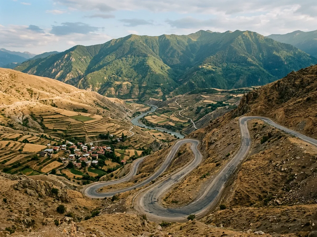
The southern descent into the Coruh valley is gentler in gradient, with longer straights and wider curves. You arrive in Ispir having descended from alpine wilderness into semi-arid canyon country, a transition that feels like driving between continents.
The only argument for south-to-north is sunset. The northern side, catching late afternoon light through the forest canopy, can be spectacular. But you can always come back.
Kilometer by kilometer
Km 0-10: Tea country to tree line
The road leaves Ikizdere heading south on the old pass road (not the tunnel approach — follow signs for “Ovit Gecidi” rather than “Ovit Tuneli”). The first section winds through the tea plantations that blanket every hillside on the Black Sea coast. The vegetation is tropical in its density — rhododendrons, ferns, moss-covered stone walls. The road is good asphalt, two lanes, and the gradient is gentle.
Around the 800-meter mark, tea gives way to mixed deciduous forest. The road narrows slightly and the hairpins begin, though these early switchbacks are wide and well-surfaced. Traffic here consists primarily of local trucks supplying the villages that dot the lower slopes — the last permanently inhabited settlement is around 1,200 meters.
Km 10-18: The forest climb
The forest thickens and the road steepens. Hairpins 1 through 8 (we number from the point where they get serious, around 1,400 meters) climb through dense spruce and pine forest. The road surface remains asphalt but the quality deteriorates — frost heave has created undulations, and patches of repair asphalt create an uneven surface that rewards smooth driving.
The temperature drops noticeably. If you left Ikizdere in shorts, you will be reaching for a jacket by the time you hit the tree line at approximately 2,100 meters. The forest thins, then stops. One moment you are enclosed by trees. The next, you are on an open mountainside with views that extend to the Black Sea coast, sixty kilometers to the north.
Km 18-25: The exposed hairpins
Above the tree line, the road changes character entirely. Hairpins 9 through 18 switchback across a bare rock face with alpine meadow above and a precipitous drop below. The gradient steepens to 10-12% in places. The road narrows to one and a half lanes. Guardrails appear sporadically — present on some hairpins, absent on others, with no apparent logic to the distribution.
This section is where the Ovit earns its difficulty rating. The combination of altitude (your engine loses roughly 15% of its power at 2,500 meters), narrow road, steep gradient, and exposure requires concentration. In low-powered rental cars, you may find yourself in first gear on the steepest bends. In fog — which arrives without warning at this altitude — you may find yourself in first gear everywhere.
The rock face above the road sheds stones, particularly in spring after the snowmelt. Keep an eye on the road surface for debris and do not park beneath the cut faces.
Km 25-30: Summit and southern descent
The final four hairpins deliver you to the summit at 2,640 meters. The pass is marked by a stone monument and a small parking area. There is no cafe, no visitor center, no commercial activity of any kind — just the sign, the wind, and a 360-degree panorama of the Kackar range that includes peaks above 3,500 meters.
The southern descent begins immediately and drops steeply toward the Coruh valley. The road quality improves on this side — the asphalt is newer, the curves wider, and the gradient more consistent. The landscape transitions from alpine meadow to scrub steppe to the dry, rocky terrain of the Coruh canyon. By the time you reach Ispir (approximately 1,300 meters), you are in a different climate zone entirely.
The tunnel question
The Ovit Tunnel (Ovit Tuneli) is one of the longest road tunnels in Turkey. It was built to keep the Ikizdere-Ispir route open year-round, replacing a pass that was closed by snow for six months each year. For local communities and commercial traffic, the tunnel is transformative infrastructure.
For you, it is a thing to avoid.
| Consideration | Old pass road | Tunnel |
|---|---|---|
| Drive time | 90-120 minutes | 12 minutes |
| Scenery | Extraordinary | Fluorescent lights and concrete |
| Season | May-November | Year-round |
| Traffic | Almost none | Moderate truck traffic |
| Altitude experience | Full 2,640m | None (tunnel at ~1,800m) |
| Road surface | Variable asphalt | Perfect |
| Fuel needed | Moderate (30km with gradient) | Minimal |
The old pass road is accessible from the same junction as the tunnel. At the fork, signs point left for the tunnel and right for the old road. Turn right. The GPS will complain. Ignore it.
Km 30-45: The Coruh descent
Below the pass on the southern side, the road follows the upper Coruh valley toward Ispir. This section is less dramatic than the northern climb but has its own stark beauty. The valley narrows to a canyon in places, the river visible far below, and the dry mountain slopes are terraced with ancient stone walls from centuries of highland agriculture.
Ispir itself is a small town with fuel, basic accommodation, and a 12th-century castle ruin. If you are continuing on the Eastern Turkey Pass Expedition, Ispir is a logical overnight stop.
Practical information
| Detail | Information |
|---|---|
| Opening dates | Typically May to November, snow-dependent. Check karayollari.gov.tr or ask locally. |
| Toll | None |
| Fuel | Last fuel north: Ikizdere. Last fuel south: Ispir. No fuel on pass. ~80km gap. |
| Parking | Small lots at summit monument and at two viewpoints on northern ascent |
| Best time of day | Morning for clearest conditions. Afternoon fog common above 2,200m. |
| Avoid | June snowmelt (rockfall risk), late October (early snow), any day with fog forecast |
| Length | 30km ascent from Ikizdere junction to summit; 15km descent to Ispir |
| Drive time | 90-120 minutes Ikizdere to Ispir via old road |
| Winter alternative | Ovit Tunnel (year-round, 12 minutes) |
Combine with nearby passes
The Ovit sits at the center of eastern Turkey’s pass country. The natural combinations:
Ovit + Zigana: Drive the Zigana Pass from Trabzon to Gumushane, then continue east to Ikizdere and climb the Ovit. Two passes in two days, from 2,032m to 2,640m, with the Black Sea coast as your connecting thread.
Ovit + Ilgaz: Add the Ilgaz Pass (2,000m, west of Kastamonu) for a three-pass traverse of northern Turkey’s mountain barrier. This is the basis of our Eastern Turkey Pass Expedition.
Ovit + Bayburt-Of road: The old road from Bayburt to Of (often called the “Derebasin road”) is a gravel mountain track that rivals the Ovit for drama. Not paved, genuinely challenging, and not on most maps. For experienced drivers only.
We have driven passes that are higher (Stelvio, Khunjerab), passes that are longer (Transfagarasan, Leh-Manali), and passes that are technically harder (Tusheti, Mangrt). But no pass we have driven compresses the range of the Ovit into so little distance. You start in tea-plantation humidity and finish in high-altitude desert. You start at sea level ambition and arrive at 2,640 meters of earned altitude. And you do it on a road that almost nobody drives anymore, which makes the whole thing feel like a secret that Turkey forgot to keep.