Zigana Pass
Every army, merchant caravan, and imperial ambition that wanted to move between the Black Sea coast and the Anatolian interior had to cross the Pontic Alps. For three thousand years, the path of least resistance was the gap in the mountains south of Trabzon — the route the Romans used, the Byzantines maintained, the Ottomans taxed, and the Silk Road caravans followed with their loads of spice, silk, and optimism. That route is the Zigana Pass. You can drive it in ninety minutes. The civilizations that built it took millennia.
The modern Zigana Tunnel, opened progressively since 2023, now carries the through-traffic. The old pass road — 20 kilometers of well-maintained asphalt climbing to 2,032 meters — has been returned to a state of quiet utility, used by shepherds, a few tourists, and the occasional driver who understands that a tunnel does not have a view.
Why drive Zigana Pass
The Zigana is not a thrill ride. It will not make your palms sweat or your brakes smoke. It earns its place on SteepPass not through technical difficulty but through historical weight and scenic transition. This is a road that connects two entirely different worlds: the humid, green, tea-growing Black Sea coast to the north and the dry, continental Anatolian plateau to the south. The transition happens over twenty kilometers, and it is as abrupt as a page turn.
On the northern side, the road climbs through forests so dense and wet that the asphalt stays damp for hours after rain. Rhododendrons line the road in June, and the slopes above are covered in the tea plantations that define the Black Sea economy. The air smells of vegetation and ocean moisture.
On the southern side, everything changes. The forest thins, the air dries, and within a few kilometers of the summit, you are looking at a landscape of brown grass, exposed rock, and scattered pines that belongs to central Anatolia rather than the coastal fringe. The pass is the continental divide, and you cross it in twenty minutes.
The other reason to drive the Zigana is practical: it is the natural first pass on the Eastern Turkey Pass Expedition, the three-pass route that continues east to the Ovit and beyond. The Zigana warms you up. It teaches you the rhythm of Turkish mountain driving — the style of hairpins, the quality of road surface, the behavior of oncoming traffic — before the Ovit demands more serious attention.
Which direction to drive
North to south, starting from the Trabzon side.
The practical reason is logistical: Trabzon is the gateway to eastern Turkey’s mountains. It has an international airport, reliable car rental agencies, and a functioning city infrastructure that makes it the obvious starting point. The aesthetic reason is that driving north-to-south gives you the dramatic climate transition in the direction that maximizes the contrast — you leave the green, misty coast and arrive in the dry interior, which feels like a revelation rather than a regression.
There is also the matter of light. The northern ascent is sheltered by the mountain ridge and benefits from the soft, diffuse light that the Black Sea moisture creates. The southern descent catches the harder, warmer light of the Anatolian sun. Driving south means ending in that warm light, which makes the dry landscape glow rather than bleach.
The south-to-north direction has one advantage: if you time it for late afternoon, the descent through the tea plantations into the Black Sea haze can be atmospheric in a way that suggests a watercolor painting that has been left in light rain. But this requires specific timing, and we recommend the north-to-south approach for a first drive.
The tea connection
The northern slopes of the Zigana are carpeted in tea. Turkey is the world’s fifth-largest tea producer, and virtually all of it grows in this narrow coastal strip between Rize and Trabzon. The Zigana Pass road threads through the upper edge of the tea zone, where the neat rows of chest-high bushes cover every surface that is not too steep for a person to stand on — and some surfaces that are.
In harvest season (May through October), the roadsides are busy with tea pickers carrying enormous wicker baskets on their backs. The freshly picked leaves are green and fragrant, and the processing factories that dot the hillsides fill the air with a toasted, vegetal scent that enters the car even with the windows up.
We stopped at a roadside tea house on the lower northern slopes — a wooden platform overlooking a valley of tea plantations — and were served a tulip-shaped glass of cay so strong it left a tannin line on the glass. The owner spoke no English and we spoke no Turkish beyond numbers and pleasantries, but tea is a universal language and hospitality in this part of Turkey is not a concept but a reflex.
Kilometer by kilometer
Km 0-5: Trabzon outskirts to the forest
The Zigana Pass road branches from the main Trabzon-Gumushane highway at a well-signed junction. The turn for the old road (Eski Zigana Yolu) is clearly marked — follow the signs for “Zigana Gecidi” rather than “Zigana Tuneli.”
The first five kilometers climb gently through the outskirts of Trabzon’s sprawl, passing scattered houses, small shops, and the last reliable fuel station before the pass. The road is good asphalt, two lanes wide, with moderate traffic that thins as you leave the urban fringe.
Above the last village, the road enters dense forest. Black Sea forest is a specific thing — evergreen, wet, layered with undergrowth that grows aggressively in the humid maritime climate. The tree canopy closes over the road in places, creating a green tunnel that filters the light and drops the temperature noticeably.
Km 5-12: The northern hairpins
The gradient steepens at around 1,000 meters, and the first hairpins appear. These are wide, well-engineered switchbacks with good visibility through each turn. The asphalt is well-maintained — the Zigana is a state highway, and even though most traffic now uses the tunnel, the road receives regular maintenance.
Hairpins 1 through 8 climb through the forest with a steady rhythm. The turns are spaced far enough apart that you can build momentum between them, and the road is wide enough for two cars to pass comfortably even on the tightest bends. This is weekend-driver territory — engaging but not demanding, scenic but not vertiginous.
The occasional roadside tea garden or rest stop offers an excuse to pause. At roughly 1,400 meters, a viewpoint on the right provides a panorama back toward the Black Sea coast. On clear days, you can see the water. On typical days, you can see the top layer of the moisture that obscures the water, which is its own kind of beauty.
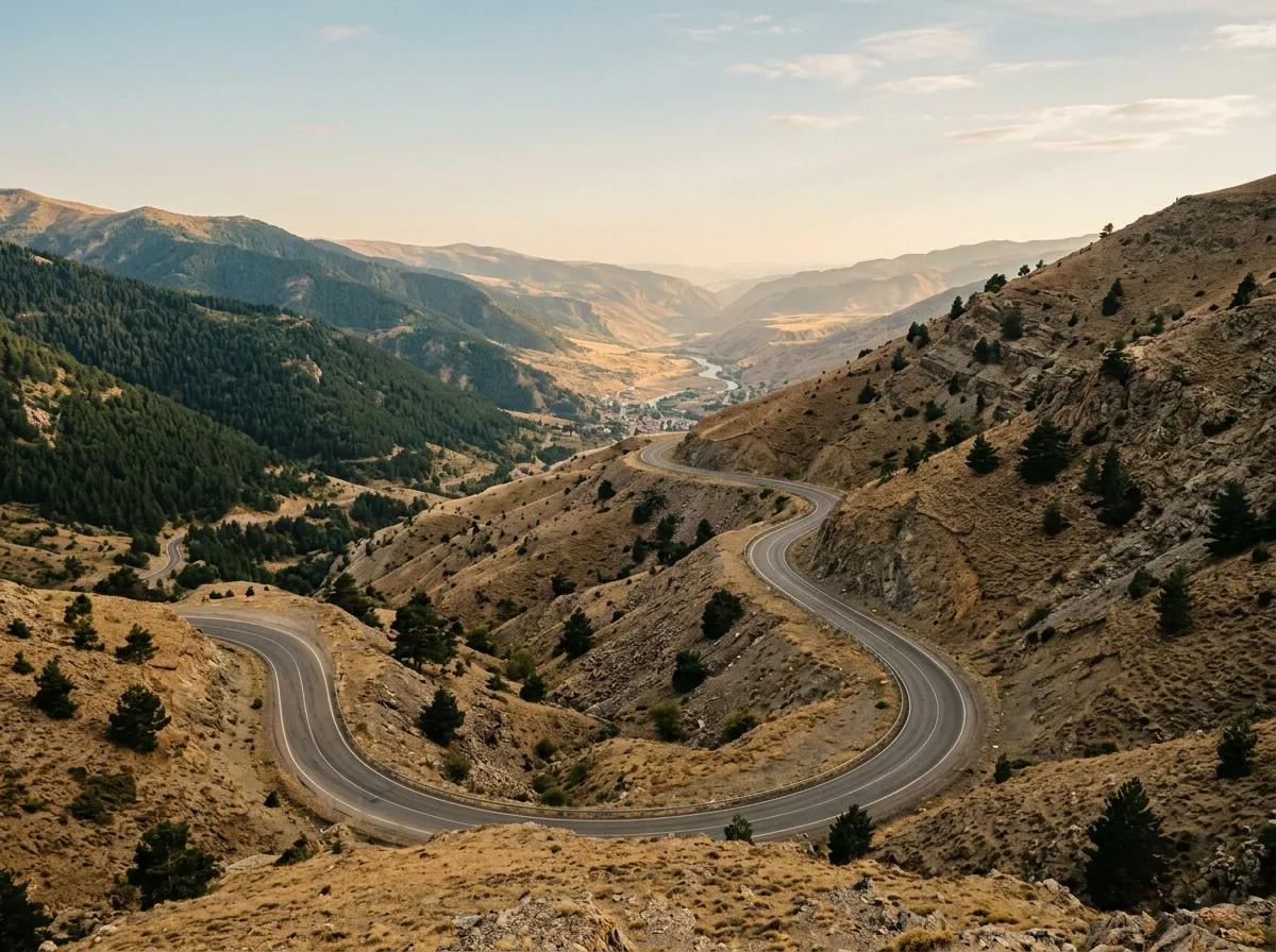
Km 12-16: Above the tree line
The tree line on the Zigana is at approximately 1,800 meters, and crossing it feels like emerging from a room into daylight. The dense forest gives way to alpine meadow in the space of a few hundred meters, and suddenly the views open to include the entire northern slope of the Pontic range.
Hairpins 9 through 14 navigate the exposed upper section. The road is narrower here but still comfortably two lanes. Guardrails are present on the outside of each turn. The gradient eases slightly as you approach the summit plateau, and the final stretch is nearly flat — a high meadow where shepherds graze cattle in summer and the wind carries the sound of bells.
Km 16-20: Summit and southern descent
The summit at 2,032 meters is marked by a collection of roadside buildings — a seasonal restaurant, a fuel station (open sporadically), and a monument. There is a ski area here in winter (Zigana Kayak Merkezi), which explains the infrastructure but not the quality of the facilities, which could charitably be described as functional.
The southern descent is gentler and straighter than the northern climb. The road drops toward Gumushane through a drier landscape of scattered pine and brown grass. The contrast with the northern side is immediate and total. Where you entered the pass in maritime humidity, you exit in continental dryness. The temperature rises. The vegetation thins. Welcome to Anatolia.

Practical information
| Detail | Information |
|---|---|
| Opening dates | Year-round on the old road, though snow chains may be required Nov-Apr |
| Toll | None |
| Fuel | Last fuel north: Trabzon outskirts. Sporadic fuel at summit. Next fuel south: Torul or Gumushane. |
| Parking | Summit area has ample parking. Several pull-offs on northern ascent. |
| Best time of day | Morning for clearest conditions on the northern side |
| Avoid | Heavy rain (road drains poorly in forest sections), ice Nov-Mar on old road |
| Length | 20km from junction to summit; 12km descent to Torul |
| Drive time | 60-90 minutes junction to Gumushane |
| Winter alternative | Zigana Tunnel (year-round, ~15 minutes) |
The old road vs. the tunnel
Like the Ovit, the Zigana has been bypassed by a tunnel. And like the Ovit, the tunnel serves a purpose — keeping the route open through the winter, eliminating the danger of snow and ice on the pass, reducing transit times for commercial traffic. For a truck carrying goods from Trabzon to Erzurum, the tunnel is a logical choice.
For you, it is not. The tunnel offers fifteen minutes of fluorescent-lit concrete. The old road offers ninety minutes of history, climate transition, and the specific satisfaction of driving a route that Alexander the Great’s armies would recognize. The trade-off is obvious.
The junction is clearly marked. Left for the tunnel, right for the old road. Turn right.
Historical context
The Zigana Pass has been a strategic crossing for at least three millennia:
| Era | Significance |
|---|---|
| Antiquity | Persian Royal Road routing. Xenophon’s Ten Thousand crossed here in 401 BC. |
| Roman | Trade route connecting Trapezus (Trabzon) to the interior. Military road. |
| Byzantine | Key defensive position. Control of the pass = control of the coast. |
| Silk Road | Major transit point for goods between Persia/China and the Black Sea ports. |
| Ottoman | Primary route between Trabzon port and eastern Anatolia. Maintained caravanserais. |
| Modern | Highway built 1916 during Russian occupation, upgraded throughout 20th century. |
Xenophon described the crossing of the Pontic Alps in his Anabasis, and while scholars debate whether his specific route crossed the Zigana or a nearby parallel route, the geography leaves limited options. The pass has been the path of least resistance for anyone moving between the coast and the interior, and driving it today puts you on a route worn smooth by thirty centuries of traffic.
Combine with nearby passes
Zigana + Ovit: The natural combination. Drive the Zigana from Trabzon to Gumushane, then head east along the coast to Ikizdere and climb the Ovit Pass to 2,640 meters. Two passes, two days, a combined elevation of 4,672 meters.
Zigana + Kop Pass: From Gumushane, continue south toward Bayburt and the Kop Pass (2,390m). Less dramatic than the Ovit but geographically significant — the Kop crosses the eastern extension of the Pontic range.
Full Eastern Turkey Expedition: The Zigana is the first pass on our Eastern Turkey Pass Expedition, a five-day, three-pass traverse that chains the Zigana, Ovit, and Ilgaz into a continuous mountain driving route across northern Turkey.
The Zigana is a pass you drive for context. It teaches you the Black Sea climate, introduces you to Turkish mountain road engineering, and drops you on the correct side of the mountains for everything that follows. It is not the most dramatic pass on this site, and it does not pretend to be. But it is one of the oldest roads in continuous use on the planet, and driving it with that knowledge — knowing that your tires are rolling over the same route that carried Persian tribute and Silk Road spices — adds a weight to the experience that altitude alone cannot provide.