Balan Pass — The Quiet Crossing
Not every mountain pass needs to be famous. Not every mountain pass needs to have its own episode of Top Gear, its own drone footage on YouTube, or its own queue of campervans waiting to crawl up its hairpins at 15 km/h. Some mountain passes are just mountain passes – roads that go over mountains because the mountains are there and people on one side need to reach people on the other side. These roads are not lesser. They are simply unburdened by expectation, and there is a purity to driving them that the famous passes, for all their grandeur, have lost.
The Balan Pass (DJ123) is this kind of road. It crosses the Eastern Carpathians at approximately 1,200 meters, connecting the Harghita and Covasna counties in the heart of Transylvania. It does not have the altitude of the Transfagarasan or the Transalpina. It does not have their fame, their drama, or their crowds. What it has is 45 kilometers of winding mountain road through some of the most quietly beautiful forest in Romania, a summit that feels genuinely remote despite being only 80 km from Brasov, and a driving experience that is less about adrenaline and more about the steady, cumulative pleasure of a well-driven mountain road on a good day.
We include Balan Pass in our Romanian coverage not as a consolation prize for people who cannot handle the big passes, but as a genuine recommendation for drivers who value the experience of driving over the spectacle of scenery. The Carpathians are not only the Fagaras range. The Eastern Carpathians – the volcanic Harghita Mountains, the forested ridges of Covasna, the wide valleys of Szeklerland – are a different landscape entirely, and the Balan Pass is the road that takes you through it.
Why drive the Balan Pass
The Balan Pass connects the town of Balan (in Harghita County, the heartland of Romania’s ethnic Hungarian Szekler community) with the Buzau Valley to the southeast. The road was built to service the mining operations in the Balan area – copper and other metals were extracted here for centuries, and the town’s name derives from the mining terminology of the region. The mining is largely finished now, and the road serves mainly local traffic: farmers, foresters, the occasional bus.
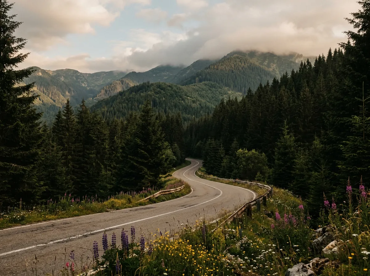
The driving case for the Balan Pass is not altitude or hairpins but rhythm. The road winds through dense mixed forest – beech, oak, hornbeam, and spruce – following river valleys and climbing gradually through a series of gentle curves that flow into each other naturally. There are about 30 turns that could reasonably be called hairpins, but they lack the severity of the Transfagarasan’s switchbacks. Most can be taken in third gear without significant braking. The gradient is moderate – rarely exceeding 8-10% – and the road, while not consistently excellent, is adequate throughout.
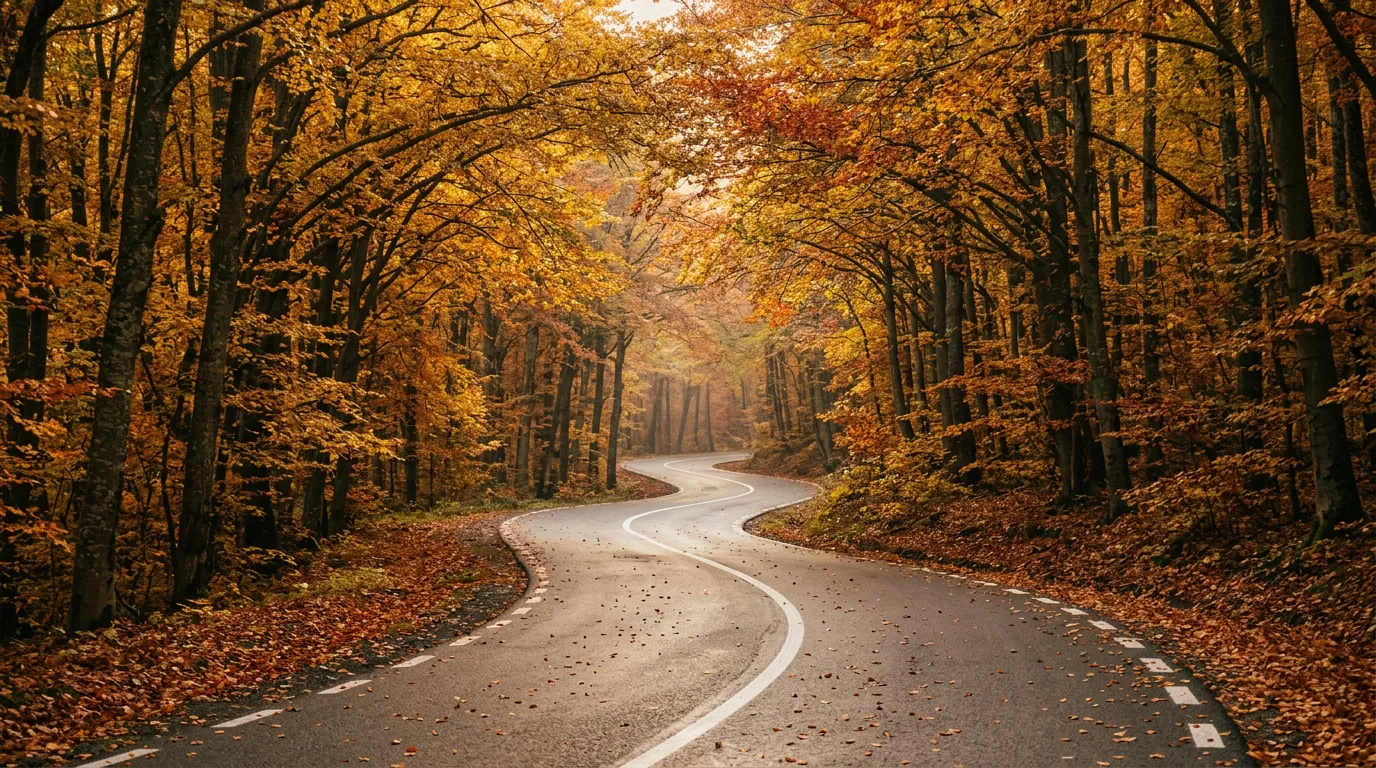
The scenery is forestry rather than alpine. You will not see dramatic peaks or exposed ridgelines. Instead, you drive through a canopy of trees that, in autumn, produces colors that rival anything in the Carpathians – deep reds, burning oranges, and the particular yellow of beech leaves in October that seems to glow from within. In spring, the forest floor is carpeted with wildflowers, and the streams beside the road run fast with meltwater. In summer, the canopy provides shade, and the road is several degrees cooler than the valleys at either end.
The wildlife is the other reason to drive slowly. The Eastern Carpathians are home to one of the largest populations of brown bears in Europe, along with wolves, lynx, deer, and wild boar. We have seen deer on the road three times on this pass and bear tracks in the roadside mud once. The animals are more active at dawn and dusk, which is another reason to time your drive for early morning – the light is better, the traffic is nonexistent, and you might see something that the Transfagarasan’s tour bus queues will never show you.
Which direction to drive
East to west, from the Buzau Valley toward Balan. This direction has you climbing gradually through the most scenic sections of forest and arriving at the summit from the more dramatic side. The western descent into Balan is gentler and somewhat less interesting – mining heritage and town approaches rather than forest – so getting it over with as the second half of the drive makes sense.
That said, direction matters less on the Balan Pass than on the Transfagarasan or Transalpina. There are no stacked hairpins where one direction is clearly superior. No summit reveal that works only from one approach. The road is enjoyable in both directions, and if your itinerary demands the opposite direction, you will not miss anything significant.
Kilometer by kilometer
Eastern approach: Buzau Valley to the forest (0-10 km)
The road begins at a junction in the upper Buzau Valley, where the DJ123 branches off the main valley road. The first 10 km are valley driving – agricultural land, scattered houses, the river beside the road. The settlements here are small and predominantly Szekler – Romanian villages with Hungarian-language signs, wooden gates, and a character distinct from the Saxon towns further south or the Romanian villages to the east.
The road surface is fair – asphalt, mostly intact, with some patching. Speed limit signs suggest 50 km/h through the villages, and this is reasonable given the occasional pedestrian, farm vehicle, or horse-drawn cart. Yes, horse-drawn carts. This is rural Transylvania. They are a feature, not an anachronism.
The forest climb (10-30 km)
The valley narrows and the forest closes in. The road begins climbing through mixed deciduous forest, and the driving begins in earnest. The curves are smooth and well-graded, following the contours of the hillside rather than cutting through them. This is a road that works with the terrain rather than against it, and the result is a natural flow that rewards smooth, unhurried driving.
The gradient increases gradually. By kilometer 15, you are gaining altitude consistently, and the forest composition starts to change – more spruce, fewer beech, the understory thinner and the canopy denser. Small streams cross the road in several places – most are properly bridged, a few run over the road surface in shallow fords that are passable in any vehicle but add a pleasant sense of remoteness.
By kilometer 20, the road is solidly in the mountains. The curves tighten slightly, the gradient steepens, and the forest alternates between dense spruce and clearings where old logging tracks branch off into the trees. The clearings offer occasional views of the surrounding ridges – not dramatic, but atmospheric. On a misty morning, the forest layers recede into progressively paler shades of green, each ridge fainter than the last, until the furthest ones are barely distinguishable from the sky.
We met a logging truck between kilometers 22 and 23 – a flatbed stacked with spruce trunks, moving slowly downhill. The driver pulled over to let us pass, and as we went by he raised a thermos in a gesture that was either greeting or toast. This is the Balan Pass in microcosm: functional, quiet, inhabited by people who use the road for its intended purpose.
The summit (30-35 km)
The summit of the Balan Pass is not a dramatic event. There is no tunnel, no lake, no viewing platform with a glass floor. There is a road sign indicating the altitude (approximately 1,200 meters, though markings vary), a widened pullout where you can stop, and a view through the trees to the ridges on either side. The summit feels like the high point of a forest walk rather than the climax of a mountain pass, and this is entirely appropriate for a road whose appeal is cumulative rather than momentary.
The air at the summit is noticeably cooler and cleaner than the valleys. In summer, when the lowlands are hot and dusty, the summit temperature is a comfortable 15-20 degrees, and the breeze carries the scent of spruce resin and damp earth. Stop here. Get out. Stand in the road (checking for logging trucks first) and listen to the forest. This is what mountain driving sounds like when the mountains are not performing for an audience.
Western descent to Balan (35-45 km)
The descent toward Balan is shorter and steeper than the eastern climb. The road drops quickly through spruce forest, with several proper hairpin turns that are tighter than anything on the eastern approach. These hairpins are well-surfaced and not particularly exposed, but they require attention – the gradient here can reach 10-12%, and the road is narrower than the eastern side.
The forest thins as you approach Balan, giving way to cleared hillsides and the outskirts of the town. Balan itself shows its mining heritage – industrial buildings, some abandoned, some repurposed, and a town center that is functional rather than picturesque. The mining-era architecture has a certain Soviet-utilitarian charm if you are disposed to find charm in concrete, and the town is making efforts at renewal. There are a couple of restaurants and a fuel station.
From Balan, you can head north toward Gheorgheni and the Bicaz Gorges (another driving highlight, though not a mountain pass in the traditional sense), west toward Sovata and the Transylvanian Plateau, or south toward Brasov and the more famous roads of the Southern Carpathians.
Practical information
| Detail | Info |
|---|---|
| Road designation | DJ123 |
| Opening dates | Year-round (may require snow chains in winter) |
| Toll | Free |
| Fuel | Balan (west), limited options on eastern approach – fill up in Targu Secuiesc or Covasna |
| Parking | Summit pullout accommodates 3-4 cars. Informal pullouts throughout. |
| Best time | October (autumn colors in the beech forest), May-June (wildflowers), early morning any season |
| Avoid | Weekday mornings in logging season (truck traffic) |
| Road closures | Rare – road is maintained year-round, but heavy snow can cause temporary closures |
| Wildlife | Bears, wolves, lynx, deer. Drive carefully at dawn and dusk. |
| Mobile coverage | Unreliable in the forest sections. Coverage returns near towns. |
When to drive the Balan Pass
The Balan Pass is at its best in shoulder seasons. In October, the beech forest puts on one of the finest autumn shows in the Carpathians – the canopy road between kilometers 12 and 28 becomes a tunnel of gold and red that is worth the drive alone. In May and June, the forest floor blooms and the streams are full. In high summer, the forest provides welcome shade but the scenery is less distinctive.
Winter driving is possible but requires snow tires or chains. The road is maintained but not always promptly plowed, and the summit section can be icy. In winter, the Balan Pass is a local road driven by locals, and you should drive it at local speeds – which is to say, slowly and carefully.
Combine with nearby passes
The Balan Pass is part of our Carpathian Pass Circuit – a four-day loop from Sibiu that includes the Transfagarasan and the Transalpina. In that circuit, the Balan Pass serves as the third movement – a gentler, more meditative drive after the intensity of the big two. It is a deliberate sequencing: drama, expansion, then reflection.
For drivers interested in the Eastern Carpathians specifically, the Balan Pass combines well with the Bicaz Gorges (40 km north of Gheorgheni), one of the most dramatic canyon roads in Romania, and with the Harghita Mountains, a volcanic range with several smaller passes that are less documented but equally rewarding.
For all Romanian mountain roads, see the Romania hub.