Transalpina — The King’s Road
There is a particular satisfaction in discovering that the second-most-famous version of something is better than the first. The Transfagarasan got the television episode, the Wikipedia article, the Instagram hashtag, and the claim to “best road in the world.” The Transalpina, 100 kilometers to the west, got none of that. What it got instead was 103 extra meters of altitude, 50 extra kilometers of road, a fraction of the traffic, and the quiet confidence of a road that does not need to be told it is good.
We drove the Transalpina for the first time on a Thursday in late September, two days after driving the Transfagarasan. We did not expect much – or rather, we expected a lesser version of the same thing, a B-side to the hit single. Within thirty minutes, we had stopped making comparisons. The Transalpina is not a version of anything. It is its own road, with its own character, and the character is different enough from the Transfagarasan that comparing them is like comparing two novels by different authors who happen to write about the same country.
The Transfagarasan is dramatic – tight hairpins, a summit tunnel, a glacial lake, Ceausescu’s paranoia made concrete. The Transalpina is expansive – long sweeping curves through open alpine plateaus, vast panoramas, grazing horses at 2,000 meters, and a loneliness that the Transfagarasan lost when Jeremy Clarkson showed up. If the Transfagarasan is a thriller, the Transalpina is a landscape novel. Both are excellent. The novel is the one we keep coming back to.
Why drive the Transalpina
The Transalpina (DN67C) crosses the Parang Mountains, a range in the Southern Carpathians west of the Fagaras Mountains. At its summit of 2,145 meters near the Urdele Pass, it is the highest paved road in Romania – 103 meters higher than the Transfagarasan’s summit at Balea Lake. This distinction matters to some people (us, for instance) and is irrelevant to others, but the altitude difference reflects a broader truth: the Transalpina stays at high altitude for longer. Where the Transfagarasan climbs to its summit and immediately descends, the Transalpina runs along ridgelines and plateaus at 1,800-2,100 meters for approximately 30 kilometers, a stretch of road where you are above the clouds more often than not and the landscape looks more like Mongolia than Romania.
The road has a different history from the Transfagarasan. It was originally built in the 1930s as a strategic military road by order of King Carol II – hence its Romanian name, Drumul Regelui, the King’s Road. It was used extensively during World War II and then largely abandoned, deteriorating to a gravel track in many sections. The road was paved properly only in the 2000s, and some sections still bear the marks of this late rehabilitation – rougher surface, less consistent drainage, occasional patches where the asphalt has cracked and been repaired.
This relative neglect has preserved something that the Transfagarasan has lost: solitude. The Transalpina does not have a visitor center at the summit. It does not have a famous lake. It does not have a parking lot designed for tour buses. What it has is a small sheepfold near the summit, a few shepherds’ huts, and a view that extends across the Carpathians in every direction. On a clear day, the visibility is extraordinary – you can see mountain ranges 100 kilometers away, their outlines progressively paler as they recede toward the horizon.
Which direction to drive
North to south, starting from the Sebes end and finishing in Novaci. The reasoning is partly scenic, partly practical.
The northern approach climbs from the Sebes Valley through mixed forest, gaining altitude steadily but without the dramatic hairpin sections that characterize the Transfagarasan. The climb is gradual, almost conversational – the road rises through woodland, breaks into alpine meadow, enters a plateau zone, and then, without fanfare, deposits you on the summit ridgeline. The transition from forest to sky is seamless, and by the time you realize you are at 2,000+ meters, you have been there for several minutes without noticing.
The southern descent from the plateau to Novaci is where the road’s engineering shows. The gradient is steeper than the northern climb, and the curves tighter. The road drops through a series of sweeping switchbacks (less tight than the Transfagarasan’s but more sustained) into the Jiu Valley, passing through zones of altitude that each have their own character – bare rock, then scrubby alpine vegetation, then conifer forest, then deciduous forest, then valley farmland. The descent is a journey through climate zones, each transition marked by a change in the air temperature, the vegetation, and the quality of the light.
Driving south also means you have the sun behind you for most of the day (assuming you start in the morning), which improves visibility on the ridgeline and makes the southern panoramas glow.
Kilometer by kilometer
Northern approach: Sebes to the plateau (0-45 km)
The Transalpina begins at a roundabout near Sebes (or, more precisely, at a junction on the E81 south of Sebes) and heads south into the mountains. The first 20 km are unremarkable – a two-lane road through the foothills, passing through a couple of villages and climbing gently through agricultural land. If you have driven the Transfagarasan’s equally unremarkable northern approach, you will be familiar with this pace. It builds.
By kilometer 25, the road enters the forest. The gradient increases. The curves become more frequent, more engaging. The surface quality varies – some sections are smooth and recently repaved, others show the wear of a road that was neglected for decades and rehabilitated in stages. Nothing is dangerous or even particularly rough, but the inconsistency reminds you that this road’s history is more complicated than the Transfagarasan’s.
At kilometer 35, the road passes through the Oasa Valley and the Oasa Reservoir, a long, narrow body of water surrounded by spruce forest. The reservoir is beautiful in a severe, northern way – dark water, dark trees, dark mountains. There is a small dam at the end, and the road crosses it. On the far side, the final ascent to the plateau begins.
The plateau: Oasa to Urdele Pass summit (45-75 km)
This is the Transalpina’s defining section, and it is unlike anything on the Transfagarasan or, for that matter, on any other pass road we have driven in Europe.
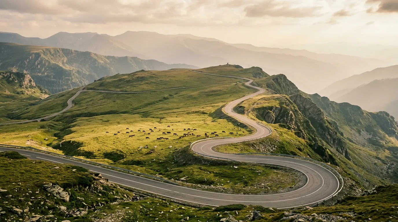
The tree line falls away and the road enters a high alpine plateau. Not a summit – a plateau. The road runs at 1,800-2,100 meters for approximately 30 kilometers, crossing a landscape that is open, vast, and almost entirely empty. The vegetation is low – grass, mosses, occasional patches of mountain flowers in June. The terrain rolls gently, like a frozen ocean. There are no trees, no buildings (aside from a few shepherds’ huts), and often no other vehicles.
The road itself is not demanding here – the curves are gentle, the gradient minimal, the surface adequate. What makes this section extraordinary is the environment. You are driving through the sky. The mountains around you are not above you – they are at your level, stretching to the horizon in every direction. Clouds pass below you. Eagles circle at eye level. The wind is constant and sometimes fierce – we have driven through gusts that required two-handed steering at 60 km/h.
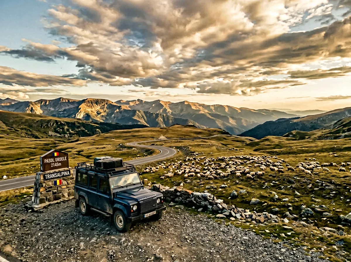
On our September drive, we stopped at the Urdele Pass summit (2,145m) and got out of the car. The silence was absolute. No engine noise, no traffic, no wind for once – just the sound of grass moving and, somewhere below, a sheepbell. We stood there for ten minutes. It was one of those moments where the road, the driving, the vehicle, all of it becomes secondary to the place itself. The Transalpina brought us here. The place is why we came back.
The Urdele Pass (2,145m) is the official summit, marked by a sign and a small pullout. There is usually a shepherd nearby with a flock and a couple of dogs that show more interest in your sandwiches than in you. The views are panoramic and disorienting – without trees or buildings for scale, it is difficult to judge distances. Everything feels simultaneously far away and right in front of you.
The southern descent: Urdele to Novaci (75-140 km)
South of the summit, the road begins to descend, and the character changes. The plateau gives way to ridgeline, and the ridgeline gives way to mountainside. The curves tighten. The gradient increases. The guardrails appear (a reassuring sign that someone official has acknowledged the drop on your left).
The descent through the Parang Mountains is where the Transalpina reveals its engineering. The switchbacks are wider and more flowing than the Transfagarasan’s – better suited to maintained speed than the start-stop rhythm of tight hairpins. You can drive this section with a smoothness and flow that the Transfagarasan rarely allows, holding a consistent speed through curves that are perfectly banked for the gradient. It is deeply, mechanically satisfying driving.
The forest returns around 1,600 meters – spruce first, then mixed, then deciduous. The temperature rises with each hundred meters of altitude lost. By the time you reach the outskirts of Novaci, you are back in a lush green valley with roadside vendors selling cheese, honey, and palinca (Romanian fruit brandy – do not sample while driving, despite the vendors’ encouragement).
Novaci itself is a small town with limited services. Fuel up here – the next proper station depends on your onward direction. Head east for Ramnicu Valcea and the connection to the Transfagarasan. Head west for Targu Jiu and Gorj County.
Practical information
| Detail | Info |
|---|---|
| Road designation | DN67C |
| Opening dates | Typically mid-June to late October (later opening than Transfagarasan due to higher altitude) |
| Toll | Free |
| Fuel | Sebes (north), Novaci (south). No fuel on the pass – carry a full tank. |
| Parking | Small pullouts throughout. No formal parking lots on the plateau. |
| Best time | Late June (wildflowers on the plateau), September (autumn colors, empty road) |
| Avoid | Early season (road may be partially snow-covered), weekends in August |
| Road closures | Check CNAIR or Infotrafic Romania for current status |
| Livestock | Sheep, cattle, and horses graze freely on and beside the road above 1,500m. Expect animals on the road. |
| Mobile coverage | Intermittent above 1,500m. Reliable only in valleys and towns. |
Transalpina vs. Transfagarasan
This comparison is inevitable, so here it is:
| Transfagarasan | Transalpina | |
|---|---|---|
| Summit altitude | 2,042m | 2,145m |
| Total length | 90 km | 140 km |
| Character | Dramatic, concentrated, famous | Expansive, open, quiet |
| Hairpins | Tight, stacked switchbacks | Sweeping, flowing curves |
| Summit feature | Balea Lake + tunnel | Open plateau + shepherds |
| Traffic | Heavy in summer | Moderate to light |
| Road surface | Consistently good | Variable (some rough sections) |
| Best for | Photography, bucket-list driving | Sustained driving pleasure, solitude |
Both are difficulty 3 – Confident driver. Both are worth driving. If you have time for only one, choose based on what you want: spectacle (Transfagarasan) or immersion (Transalpina). If you have time for both – and our Carpathian Pass Circuit gives you both in four days – drive the Transfagarasan first and the Transalpina second. The Transalpina is a better second course than a first.
Combine with nearby passes
The Transalpina is part of our Carpathian Pass Circuit – a four-day loop from Sibiu that includes the Transfagarasan, this road, and the Balan Pass.
For all Romanian mountain roads, see the Romania hub.