Transfagarasan — The Best Road in the World
In 2009, Jeremy Clarkson stood on the Transfagarasan Highway, gestured at the road snaking through the Carpathian Mountains behind him, and declared it “the best road in the world.” The clip went viral. The Romanian tourism ministry presumably sent him flowers. Within a few years, the Transfagarasan went from an obscure Romanian mountain highway known mainly to locals and motorcycle tourists to one of the most famous driving roads on the planet, with its own Wikipedia page, its own Instagram hashtag, and a visitor count that would have astonished the military engineers who built it in the 1970s.
We have driven the Transfagarasan seven times over four years, in different cars, different seasons, and different weather. We have driven it in June when the summit was still half-buried in snow and in October when the Carpathian beech forests were so red they looked combustible. We have driven it on a Tuesday morning with the road entirely to ourselves and on a Saturday in August when it felt like every car in Romania had the same idea. After all of that, we have arrived at a nuanced position on Clarkson’s claim: he was mostly right. It is an extraordinary road. Whether it is the best depends on what you mean by best, and on whether you drive it in the right direction.
Why drive the Transfagarasan
The Transfagarasan (DN7C) crosses the Fagaras Mountains, the highest range in Romania, at an elevation of 2,042 meters. It runs for approximately 90 kilometers from Curtea de Arges in the south to the town of Cartisoara in the north, climbing from verdant foothills through dense beech and conifer forest, past the alpine lake of Balea, through a summit tunnel, and down the southern face in a series of sweeping curves that are genuinely, objectively, one of the great pieces of road engineering in Europe.
The road exists because of Nicolae Ceausescu’s paranoia. After the 1968 Soviet invasion of Czechoslovakia, Ceausescu – who had publicly condemned the invasion, making Romania a sudden and unlikely hero of Western opinion – began to fear that the Soviets would do the same to him. He ordered a military road built across the highest point of the Carpathians to allow rapid troop movements between the north and south of the country if the mountain passes were blocked. The road was built between 1970 and 1974, mostly by military engineers and conscript labor, at a cost that has never been officially disclosed but is rumored to have included several dozen lives.
The result is a road that was never intended for tourism, pleasure driving, or Top Gear segments. It was built to move tanks across a mountain range. That it happens to be exquisitely beautiful is an accident of geography – the Fagaras Mountains are stunning, and any road crossing them would be spectacular. That the road is also technically excellent – well-graded, well-drained, with sight lines and curve radii that reward skilled driving – is a testament to the military engineers who, whatever the politics that sent them here, knew how to build a road.
Which direction to drive
North to south. We will now explain why, at length, because this is the hill we are prepared to die on.
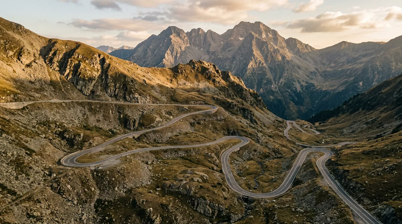
The northern face of the Transfagarasan is where the famous hairpins are – the tight, stacked switchbacks that appear in every photograph and drone video of the road. These hairpins climb from the tree line at about 1,400 meters to the summit at 2,042 meters, gaining 640 meters of altitude in roughly 20 kilometers of road through approximately 40 numbered switchbacks. It is this section that Clarkson was talking about. It is this section that earns the road its reputation.
Driving north to south means you descend these hairpins. This might seem counterintuitive – surely climbing is more dramatic? – but consider:
The reveal. Approaching from the north, you drive through the Olt Valley, then climb gradually through forest. The trees thin. The terrain opens. And then, as you crest a ridge, the entire southern face of the Fagaras range is laid out before you, and the road drops away in a cascade of switchbacks that stretches to the valley floor. It is the single most dramatic view on the entire road, and it happens before you start the hairpins. Driving south to north, you are climbing toward this view and it arrives incrementally – you never get the full panorama at once.
The hairpin experience. Descending in second gear, you can focus on the road, the views, and the rhythm of the turns. Climbing requires more throttle management, more gear changes, more attention to the engine. The road is engineered for descending – the sight lines, the drainage, the camber all favor the downhill driver.
Balea Lake. The summit of the Transfagarasan passes through a short tunnel (about 900 meters) and emerges at Balea Lake, a glacial cirque lake at 2,034 meters. Coming from the north, you arrive at Balea Lake after the hairpins, which means you arrive having already experienced the best section of the road and can enjoy the lake as a reward, not an appetizer. Coming from the south, Balea Lake is a rest stop before the main event, which is less satisfying narratively.
The crowds. Most tour groups approach from the south (from Curtea de Arges), because the southern approach has better hotel infrastructure and is closer to Bucharest. By starting from the north, you encounter these groups on the hairpins after they have already been driving for two hours and are tired, slower, and easier to pass. Coming from the south, you meet them fresh and enthusiastic, and they are everywhere.
The one caveat: the southern approach, from Curtea de Arges, passes the magnificent Poienari Fortress (the real Dracula’s castle, not the Bran tourist trap), the Vidraru Dam (one of the tallest in Europe), and the Vidraru Reservoir, which is a beautiful turquoise expanse surrounded by forest. These are worth seeing. Our solution: drive the Transfagarasan north to south, then drive back along the southern approach to see Poienari and Vidraru. The road deserves to be driven twice.
Kilometer by kilometer
Northern approach: Cartisoara to the tree line (0-35 km)
The Transfagarasan begins (or ends, depending on your direction) at a junction near Cartisoara, a village in the Olt Valley south of Sibiu. The first 35 km run through the valley and into the foothills, following the Olt River through a landscape of meadows, scattered farms, and mixed forest. The road is two lanes, well-maintained, and gently ascending. You might wonder what the fuss is about. Keep driving.
The valley narrows progressively. The farms become less frequent. The forest closes in – first deciduous (beech and oak), then mixed, then predominantly conifer. The road quality remains excellent, but the curves become more frequent and the gradient steeper. By kilometer 25, you are climbing properly, and the valley is more gorge than valley.
The forest climb (35-50 km)
The road enters dense spruce forest and the ascent begins in earnest. The curves are wide and well-banked – proper alpine highway curves, not hairpins yet – and the surface is smooth. This section is pure driving pleasure: fast, flowing, with enough gradient and enough curves to keep you engaged without demanding the full-attention driving that comes later.
The forest thins as you gain altitude. Clearings appear, offering views back down the valley. By kilometer 45, you can see the first patches of bare rock above the tree line. The air is noticeably cooler. If it was 30 degrees in the valley, it is 20 here, and it will be 10 at the summit.
The hairpin section: tree line to summit (50-70 km)
This is the Transfagarasan. Everything else is preamble.
The tree line falls away and the road enters the high alpine zone: bare rock, low scrubby vegetation, patches of late-season snow, and sky. A lot of sky. The Fagaras peaks surround you, rising to 2,544 meters (Moldoveanu, the highest point in Romania) to the east. The road surface is still good but rougher than the forest section, with some cracks and patches near the drainage channels.
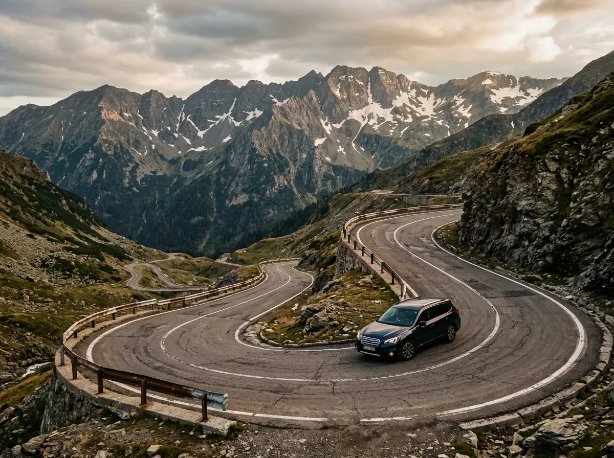
The hairpins begin. They are numbered, helpfully, with small posts at each turn. The first few are gentle – wide curves that could be taken at moderate speed. By hairpin 15, they tighten. By hairpin 25, they are proper switchbacks – turn, climb 50 meters, turn back, climb 50 meters. The rhythm is steady and relentless.
We drove this section in early October and met precisely three other vehicles in twenty kilometers. The Carpathians were gold and red below us, the peaks above were dusted with the first snow, and the only sound was the engine and the wind. It was, without qualification, one of the finest hours of driving we have ever experienced.
Between hairpins 30 and 40, the road passes several viewpoints where you can pull over and look back at the switchbacks below. These are the shots you have seen in photographs – the road drawing zigzag lines across the barren mountainside, each switchback stacked above the last. In person, it is more impressive than any photograph, because photographs cannot convey the scale. The road below looks like a toy track. The cars on it are insects.
Balea Lake and the tunnel (70-72 km)
The summit tunnel (884 meters long, unlit except for your headlights and the headlights of oncoming traffic) passes through the ridge and deposits you at Balea Lake. The lake sits in a glacial cirque at 2,034 meters – a bowl of dark water surrounded by scree slopes and, in early summer, large snowfields. There is a chalet, a restaurant, and in winter a famous ice hotel.
In summer, Balea Lake is crowded. Tour buses can reach it from the south (barely – the hairpins test their drivers considerably), and the parking area fills by midday. Arrive early or pass through quickly. The views are worth a stop but not a queue.
From Balea Lake, the road begins its southern descent.
Southern descent (72-90 km)
The southern face is less steep than the north, and the descent is more gradual. The road sweeps through long curves as it descends through alpine meadows, then forest, toward the Arges Valley. This section is fast and flowing – more like a B-road in the Scottish Highlands than an alpine pass road.
The Vidraru Dam appears to the south, a 166-meter concrete arc blocking the Arges River. The reservoir behind it is an improbable shade of turquoise. The road crosses the dam itself, which is an experience – you are driving across the top of one of the tallest dams in Europe, with a drop of 166 meters on one side and a reservoir stretching into the mountains on the other.
Below the dam, the road follows the Arges Valley toward Curtea de Arges. A side road leads to Poienari Fortress, which sits on a cliff above the valley and requires a 1,480-step climb to reach. This is the real castle of Vlad Tepes (Vlad the Impaler, the historical Dracula) – not Bran Castle, which has better marketing but no actual Dracula connection. Poienari is small, ruined, and atmospheric. The climb is brutal. It is worth it.
Practical information
| Detail | Info |
|---|---|
| Road designation | DN7C |
| Opening dates | Typically late June to late October (exact dates announced by CNAIR) |
| Toll | Free |
| Fuel | Cartisoara/Sibiu (north), Curtea de Arges (south). No fuel on the pass. |
| Parking | Balea Lake: large lot, fills by 11:00 in summer. Several pullouts on hairpin section. |
| Best time | Early June (opening week, snow still visible) or September-October (autumn colors, fewer crowds) |
| Avoid | Weekends Jul-Aug (heavy traffic, Balea Lake parking chaos) |
| Night driving | Legal but inadvisable – no lighting on the pass, wildlife on the road (bears, deer) |
| Speed limits | 40 km/h on hairpin sections (enforced), 90 km/h on approach roads |
| Bears | Yes. Brown bears are present in the forests. Do not leave food in your car at Balea Lake. |
The Clarkson effect
It must be said: the 2009 Top Gear episode changed this road. Before the broadcast, the Transfagarasan was a Romanian mountain road driven mainly by Romanians, a few German motorcycle tourists, and the occasional lost truck driver. After the broadcast, it became a destination. Visitor numbers have increased every year. In peak season (July-August weekends), the hairpin section can have bumper-to-bumper traffic – a circumstance that would have baffled the military engineers who built the road for tanks, not tourist queues.
This does not diminish the road. The Transfagarasan is still extraordinary. But the timing of your visit matters more than it once did. Early mornings, weekdays, and the shoulder season (June, September, October) restore the road to something closer to what it was before a British television presenter made it famous.
Combine with nearby passes
The Transfagarasan is the anchor of our Carpathian Pass Circuit, a four-day route that also includes the Transalpina and Balan Pass. If you are driving in Romania and have the time, this circuit covers the three essential Carpathian passes in a single loop from Sibiu.
The Transalpina (DN67C) is the natural comparison and complement. It crosses the Parang Mountains 100 km to the west and is actually 103 meters higher than the Transfagarasan at its summit (2,145m vs 2,042m). It is less famous, less crowded, and in our opinion, a more enjoyable drive in many ways. See our Transalpina guide for the comparison.
For all Romanian mountain roads, see the Romania hub.