Grossglockner High Alpine Road
Austria’s most famous road charges admission. This is worth knowing upfront because the Grossglockner High Alpine Road is not a public highway — it is a toll road, privately managed, and the fee for a standard car is 41.50 EUR (2025 prices, expect annual increases). We mention this at the start because some drivers have a philosophical objection to paying for tarmac. Those drivers should go elsewhere. Everyone else should pay the toll, drive through the gate, and prepare for forty-eight kilometers of the best-maintained, most scenically absurd, and most visitor-friendly alpine road in Europe.
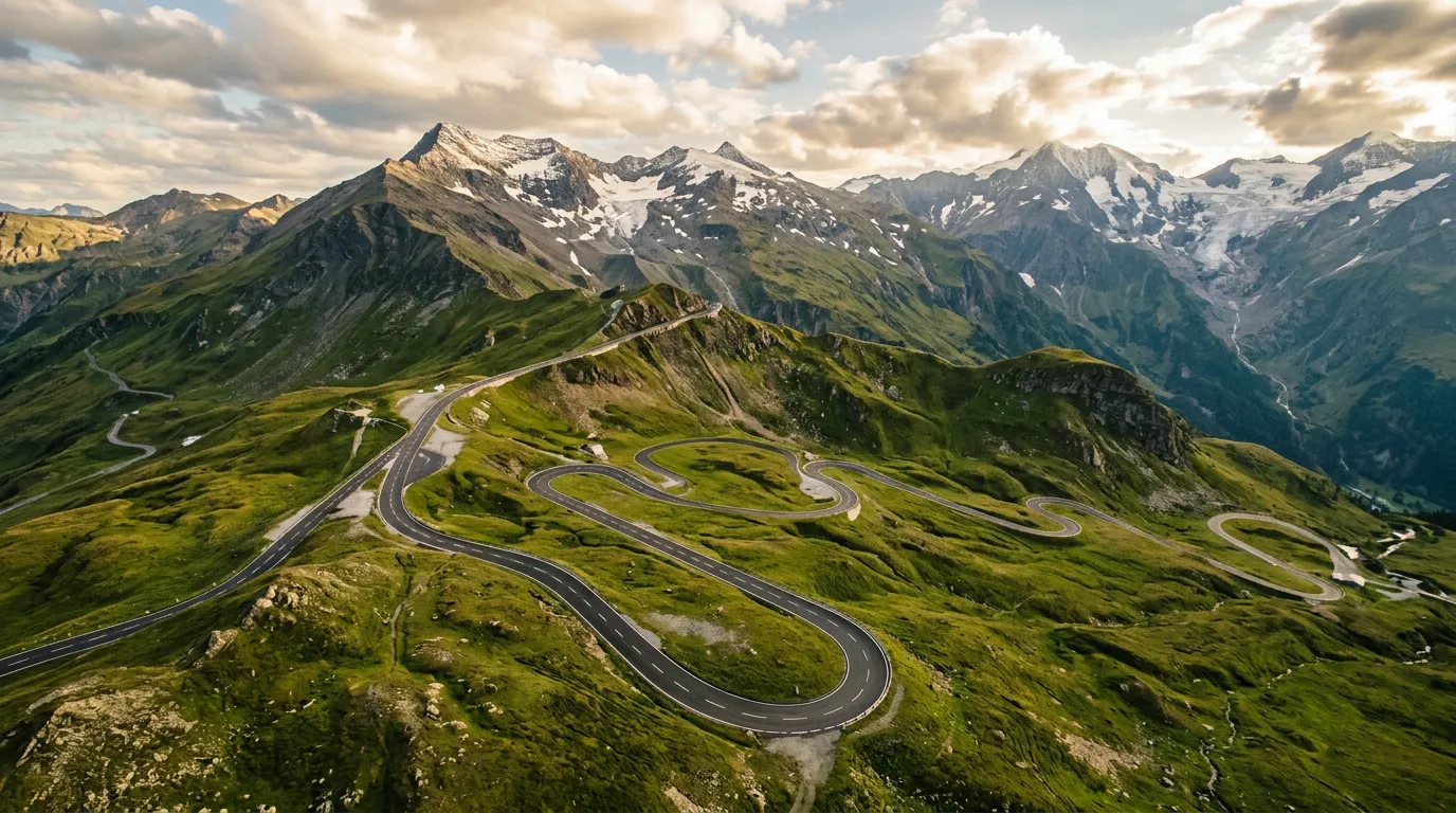
The Grossglockner is Austria’s answer to the question: “What if we built a road to the most dramatic viewpoint in the Alps and then made absolutely sure nobody had a bad time driving it?” The asphalt is flawless. The hairpins are wide and gently graded. The guardrails are engineered to catch a touring bus. The facilities — visitor centers, viewpoints, toilets, restaurants — appear at exactly the intervals a non-enthusiast driver would need them. This is a pass designed for everyone, from nervous rental car tourists to motorcycle clubs on their annual pilgrimage. And it works. The Grossglockner receives over a million visitors per year, and virtually all of them arrive by road, which means that on a peak summer day, you will share the experience with approximately four thousand of your closest friends.
Drive in shoulder season. We cannot stress this enough.
Why drive the Grossglockner
Because it earns its reputation. Many famous roads disappoint on arrival — the reality is shorter, flatter, or less dramatic than the photographs suggested. The Grossglockner is the opposite. It is longer, higher, and more varied than you expect. The road climbs from green pastoral valleys through alpine meadow into high-altitude rock desert, passing glaciers, crossing the continental divide, and terminating at a viewpoint where Austria’s highest peak (Grossglockner, 3,798m) fills the windshield with the kind of mountain presence that makes you forget you are sitting in a Volkswagen.
The Edelweisspitze (2,571m) — the highest point accessible by car on a spur road from the main route — offers a 360-degree panorama that encompasses over thirty peaks above 3,000 meters. On clear days, the view extends into Italy and Slovenia. We have been on clear days. We have also been on days when the visibility was roughly zero and the only view was of the hood ornament disappearing into cloud. Alpine weather is alpine weather.
The road also has genuine variety. The 36 hairpins are spread over 48 kilometers, which means long stretches of flowing road between the switchback sections. The landscape changes multiple times — valley forest, meadow, rock, glacier approach — giving the drive a narrative arc that shorter passes lack. This is not a road you blast through in twenty minutes. It is a half-day experience, with stops, and it rewards the time investment.
Which direction to drive
South to north. Start in Heiligenblut (1,288m, Carinthia) and finish in Bruck an der Glocknerstrasse (757m, Salzburg).
The southern approach from Heiligenblut is the more dramatic of the two entries. Heiligenblut itself — a village with a Gothic church spire that appears in every Austrian tourism brochure — sets the visual tone: this is going to be pretty and it knows it. The climb from the south gains more elevation and delivers the Edelweisspitze and Franz-Josefs-Hohe spur roads as ascending side trips rather than descending detours.
The northern descent to Bruck is gentler and makes a satisfying conclusion — the tension of the climb and the altitude resolve into an easy descent through the Fuscher Valley. You finish relaxed rather than exhausted.
Driving north to south is perfectly fine. The views are the same views. But starting in Heiligenblut gives you the better story.
Kilometer by kilometer
Km 0-10: Heiligenblut to the toll gate
The first ten kilometers from Heiligenblut climb through conifer forest and alpine meadow on well-graded curves. The toll gate is at about 1,500m — pay here, keep the receipt (it is valid for the day, and re-entry requires the receipt). Above the toll gate, the road begins its serious ascent through the first set of hairpins.
Km 10-20: The Kasereck and the climb to altitude
Above the toll gate, the road enters the Hohe Tauern National Park. The landscape shifts from pastoral to alpine with impressive speed. Hairpins stack up as the road climbs the Gamsgrubenweg side, with views back to Heiligenblut and the valley you have left behind.
The Kasereck parking area (approximately 2,000m) is the first major viewpoint. From here, you can see both the road ahead (climbing toward the Hochtor tunnel) and the road behind (dropping to Heiligenblut). This is a good photography stop and a logical brake-cooling pause.
Km 20-25: Franz-Josefs-Hohe spur road
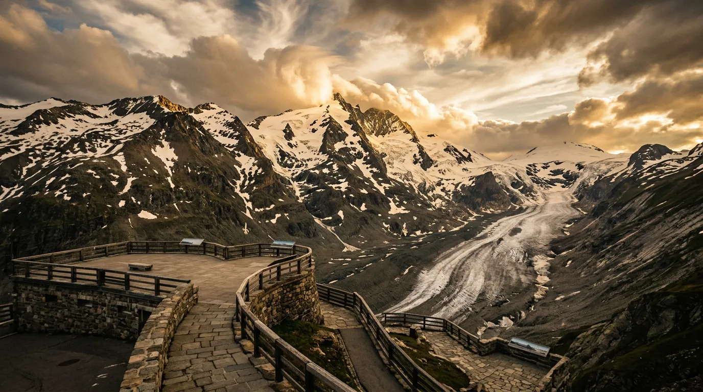
At the Guttal junction (approximately 2,100m), a spur road branches east toward Franz-Josefs-Hohe. Take it. This 9-kilometer dead-end road is included in your toll and leads to the Grossglockner’s signature viewpoint.
Franz-Josefs-Hohe (2,369m) faces the Pasterze Glacier and the Grossglockner summit directly. The glacier flows down from the peak in a river of crevassed ice that has been retreating for decades but still manages to look formidable. A multi-level viewing terrace and visitor center provide the context — the glacier’s historical positions marked on the rock show how dramatically it has shrunk, which is sobering and visually striking in equal measure.
There is a restaurant here. Have lunch. The view from the terrace, with the glacier in front of you and the Grossglockner above, is the most dramatic restaurant setting in Austria, and possibly in the Alps. The food is acceptable Austrian mountain fare. The view carries the bill.
Return to the Guttal junction and continue north on the main road.
Km 25-32: Hochtor tunnel and the continental divide
The Hochtor tunnel (2,504m above sea level at the road, though the tunnel itself passes slightly below the summit) is the highest point of the Grossglockner road and the continental divide. Water falling on the south side of this point eventually reaches the Adriatic via the Drau. Water on the north side reaches the North Sea via the Salzach and Danube.
The tunnel is short and well-lit. At its northern portal, you emerge into a different valley, a different drainage basin, and a subtly different landscape. The north side of the Grossglockner tends to catch more weather, and cloud can accumulate at the tunnel portal with startling speed.
Km 32-36: Edelweisspitze
A second spur road branches from the main route to the Edelweisspitze (2,571m), the actual highest paved point on the Grossglockner complex. The climb to Edelweisspitze is short but steep — about 2 kilometers with tight hairpins. At the top, a viewing platform provides the 360-degree panorama: the Hohe Tauern range, the Glockner group, and on clear days, a horizon that extends across multiple countries.
This is the second mandatory stop. If Franz-Josefs-Hohe shows you one mountain in overwhelming detail, Edelweisspitze shows you all the mountains at once. The two stops together are why the Grossglockner justifies its toll.
Km 36-48: Northern descent to Bruck
Below the Edelweisspitze junction, the road descends through the Fuscher Valley in long, sweeping curves. The gradient eases progressively, the forest returns, and the landscape softens into the pastoral Salzburg countryside. The northern toll gate is at approximately 1,000m, and from there it is a short drive to Bruck an der Glocknerstrasse, where you emerge onto the main Salzburg-Carinthia route.
This descent is gentle and scenic. After the intensity of the summit area, the Fuscher Valley feels like a decompression chamber — green meadows, cowbells, farmhouses. Let the car coast and your brain catch up with what you have just driven through.
Practical information
| Detail | Information |
|---|---|
| Opening dates | Early May to early November (varies by snow, check grossglockner.at) |
| Toll | EUR 41.50 per car (2025). Motorcycles EUR 30.50. Valid for same day re-entry. |
| Gate hours | May/Oct: 6:00-20:00. Jun-Sep: 5:00-21:30. Last entry 45 min before closing. |
| Fuel | Last fuel south: Heiligenblut. Last fuel north: Fusch or Bruck. None on the pass. |
| Parking | Free at all viewpoints (included in toll). Large lots at Franz-Josefs-Hohe and Edelweisspitze. |
| Best time of day | Early morning (gates open at 5 AM in summer) for clear views and empty road |
| Avoid | Weekends and Austrian holidays Jul-Aug. The road can feel like a car park. |
| Length | 48 km main road Heiligenblut to Bruck, plus 9 km Franz-Josefs-Hohe spur + 2 km Edelweisspitze spur |
| Drive time | 2-3 hours without stops; 4-5 hours with viewpoints, lunch, and photography |
| Facilities | Visitor centers, restaurants, and toilets at multiple points. This is a tourist road and it acts like one. |
Combine with nearby passes
Grossglockner + Gerlos: From Bruck (north end of Grossglockner), drive east through the Salzach Valley to the Gerlos Pass (1,507m). Gerlos is easy and scenic, connecting the Salzburg region to the Zillertal in Tyrol. Together, they make a comfortable two-pass day.
Grossglockner + Felber Tauern: The Felber Tauern tunnel (toll, south of Mittersill) provides a shortcut between the Grossglockner’s north end and the Virgental to the south. Useful for loop routes.
The Trilogy: The Grossglockner is day one of our Tyrol Pass Trilogy — combined with Gerlos and Silvretta for three days of Austrian alpine driving.
We have a simple test for alpine roads: would you drive this road if it had no scenery? The Grossglockner passes that test. Strip away the Glockner summit, the glacier, the panoramas, and you still have 48 kilometers of beautifully engineered road with 36 well-banked hairpins and perfect asphalt. That the scenery happens to be some of the most dramatic in the Alps is almost unfair. Other passes have to choose between being a good road and being a good view. The Grossglockner refuses to choose, and that is why a million people a year pay the toll.