Salzburg to Innsbruck Passes
The A12/A93 motorway from Salzburg to Innsbruck takes approximately two hours. It is a masterpiece of Austrian highway engineering: smooth, fast, punctuated by tunnels that slice through the mountains with the efficiency of a surgeon who has done this operation ten thousand times. You arrive in Innsbruck having covered 190 kilometers at 130 km/h, and the only thing you will remember is the toll booth at the Brenner approach.
We are not here to tell you the motorway is bad. We are here to tell you there is a better way — a 250-kilometer route through the mountains south of the motorway, crossing the Thurn Pass and the Gerlos Pass, threading through the Kitzbuheler Alps and the Zillertal, and arriving in Innsbruck from the south through a landscape of alpine meadow, ski villages, and valleys so photogenic that the Austrian tourist board could retire and let the views do the work.
This is not an extreme route. Both passes are well-maintained, fully paved, and open year-round (with snow chains in winter). The difficulty rating is “weekend driver” — engaging but comfortable, scenic but not terrifying. The value of this route is not in adrenaline but in substituting two hours of motorway monotony for two days of alpine satisfaction.
Route overview
| Day | Route | Pass | Elevation | Distance | Drive time |
|---|---|---|---|---|---|
| 1 | Salzburg — St. Johann — Thurn Pass — Mittersill | Thurn Pass | 1,274m | 100km | 2.5-3 hours |
| 1 (afternoon) | Mittersill — Gerlos Pass — Zell am Ziller | Gerlos Pass | 1,507m | 60km | 1.5-2 hours |
| 2 | Zell am Ziller — Zillertal — Innsbruck | Valley route | — | 90km | 1.5-2 hours |
Total: approximately 250km and 6-7 hours of driving over two days. The pace is deliberately gentle — this is a route designed for enjoyment, with time built in for viewpoint stops, village walks, and the kind of unhurried coffee that Austria does better than almost anywhere.
Day 1, morning: Salzburg to Mittersill via Thurn Pass
| Distance: 100km | Drive time: 2.5-3 hours | Pass: Thurn, 1,274m |
Leaving Salzburg
Head south from Salzburg on the B311 toward Bischofshofen, following the Salzach valley. This is a valley road through a landscape of farms, church spires, and the rounded foothills of the Northern Limestone Alps. The driving is relaxed and the scenery is the definition of “picturesque” — a word we generally avoid, but which Austria earned the right to own.
At Bischofshofen — a small town known primarily as a ski jumping venue — the road turns west on the B164 toward St. Johann in Tirol. The valley narrows, the mountains press closer, and the landscape begins to feel properly alpine rather than merely pastoral.
St. Johann in Tirol
St. Johann is a market town in the Kitzbuheler Alps with a pedestrian center, good cafes, and a view of the Wilder Kaiser mountains to the north that would stop traffic if the traffic were not already stopped at the town’s single set of traffic lights. Fuel up here. The town has everything you need for the day ahead.
From St. Johann, the road climbs south toward the Thurn Pass. The approach is gradual — a valley road that steepens progressively, passing through the village of Oberndorf and climbing through mixed forest toward the pass.
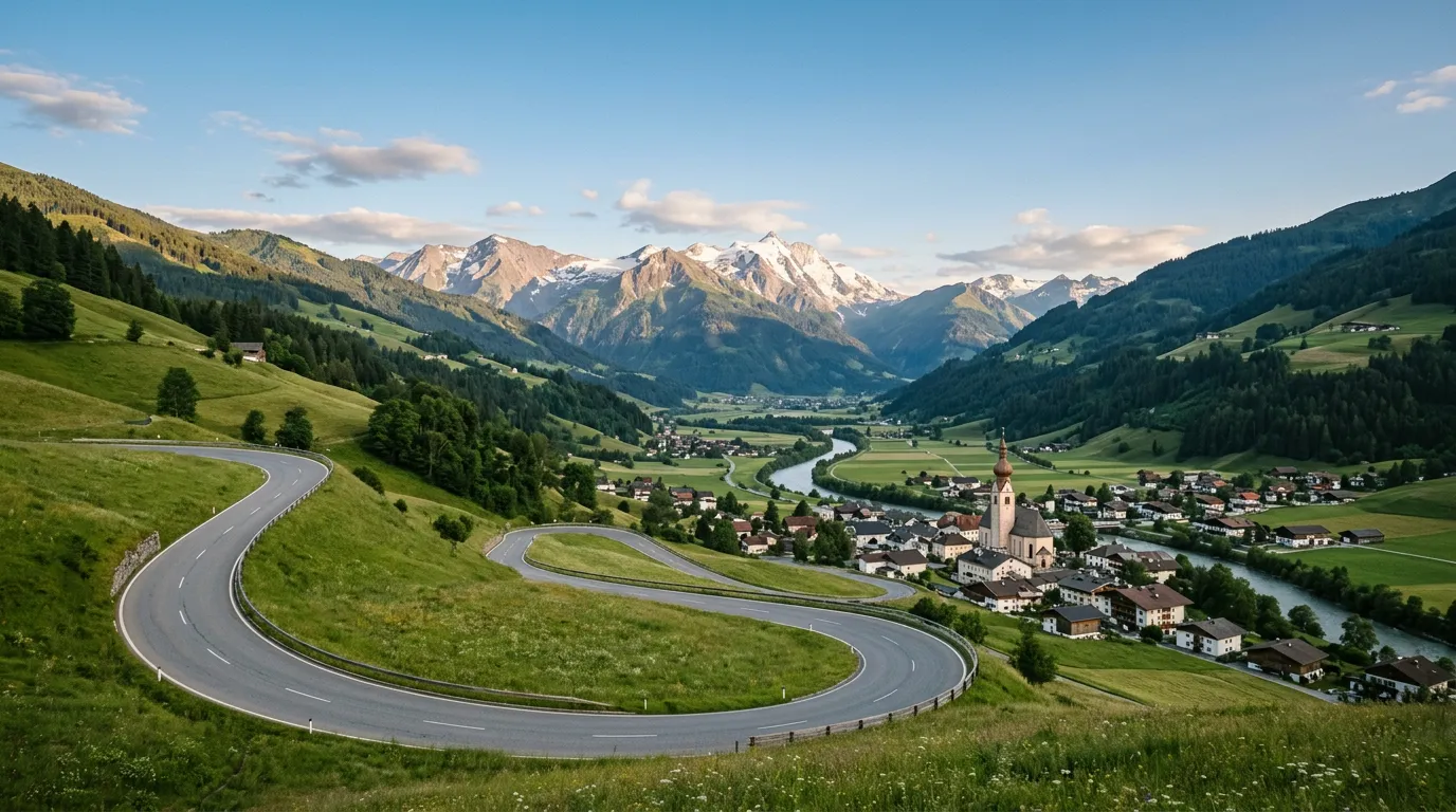
Thurn Pass (1,274m)
The Thurn Pass (Pass Thurn) is a well-maintained transit pass that connects the Kitzbuheler Alps with the upper Salzach valley. It is a year-round route — the main road between St. Johann and Mittersill — and it carries moderate traffic. The road is two lanes throughout, well-surfaced, and has guardrails on all exposed sections.
| Feature | Detail |
|---|---|
| Summit elevation | 1,274m |
| Northern ascent | 8km from St. Johann area, moderate gradient (7-8%) |
| Southern descent | 10km to Mittersill, gradual gradient (6-7%) |
| Hairpins | 6-8 wide, well-engineered curves |
| Winter conditions | Open year-round. Snow chains required when posted. Road regularly cleared. |
The Thurn is not a dramatic pass. It will not make your hands sweat or your passengers pray. What it does is carry you over the Kitzbuheler Alps at a comfortable altitude with views that unfold gently rather than assault you. The northern approach passes the Kitzbuhel ski area (home of the Hahnenkamm, one of the most demanding downhill courses in World Cup skiing), and the summit provides a panorama of the Hohe Tauern range to the south, including, on clear days, the distant white cap of the Grossglockner.
The southern descent drops into the upper Salzach valley — wide, flat, and bounded by mountains that rise dramatically on both sides. The valley floor is agricultural, with hay meadows and farmsteads that look like they were placed by a set designer with a generous budget.
Kitzbuhel detour
If you have time, the detour through Kitzbuhel is worthwhile. The town is famous for skiing, but in summer it is a prosperous Tyrolean market town with a medieval center, good restaurants, and an atmosphere of carefully maintained alpine charm. The Hahnenkamm cable car operates in summer and provides views of the pass route from above.
Mittersill
Mittersill is a small town at the junction of the Salzach and Felber valleys, and it is the logical overnight stop if you want to split the route across two comfortable days. The town has hotels, guesthouses, restaurants, and a castle (Mittersill Castle) that now functions as an international conference center.
From Mittersill, the Gerlos Pass road heads west. You can drive it the same afternoon or save it for the next morning.
Day 1, afternoon (or Day 2 morning): Gerlos Pass
| Distance: 60km | Drive time: 1.5-2 hours | Pass: Gerlos, 1,507m |
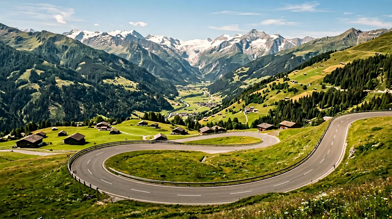
The Gerlos Pass (Gerlospass) is the highlight of this route — a proper alpine pass that climbs through the Kitzbuheler Alps and descends into the Zillertal with a combination of hairpins, waterfalls, and mountain views that justifies the entire two-day detour from the motorway.
The Gerlos Alpine Road
The Gerlos Pass is accessed via the Gerlos Alpine Road (Gerlos Alpenstrasse), which is a toll road. The toll is approximately 11-13 EUR for a car (2026 prices) and is collected at a toll station on the western approach. The toll is worth it — the road is immaculately maintained and the scenery is outstanding.
From Mittersill (or from the Salzach valley), the road climbs east to the Gerlos summit at 1,507 meters through a series of wide, well-surfaced hairpins. The gradient is moderate (8-9% maximum), and the road is two lanes with regular passing places on the wider sections.
The Krimml Waterfalls connection
Near the eastern approach to the Gerlos, the Krimml Waterfalls (Krimmler Wasserfalle) are the highest waterfalls in Austria and among the highest in Europe — 380 meters of cascading water in three stages. The falls are accessed from the village of Krimml, which is slightly off the main Gerlos route but easily included as a detour.
The walk to the upper viewing platform takes about 90 minutes and follows a well-maintained trail through spray-filled forest. It is one of the best waterfall walks in Europe, and we say this as people who generally prefer driving to walking.
| Krimml Waterfalls | Detail |
|---|---|
| Height | 380m in three stages |
| Walk time | 90 minutes to upper platform, 60 minutes return |
| Parking | Large lot at village (fee applies) |
| Best time | Morning for rainbows in the spray. Full flow Jun-Aug. |
Gerlos summit and western descent
The Gerlos summit at 1,507 meters is a broad alpine saddle with parking, a restaurant, and views in both directions. The area is used for skiing in winter and hiking in summer, and the infrastructure is well-maintained.
The western descent into the Zillertal is the more dramatic side of the pass. The road drops through a series of hairpins with views into the Zillertal below — a deep, U-shaped valley flanked by the Tuxer Alps to the south (with glaciers visible on the higher peaks) and the Kitzbuheler Alps to the north.
The descent ends at Zell am Ziller, the main town of the Zillertal and a good base for the night if you have not already stopped in Mittersill.
Zell am Ziller
Zell am Ziller is a cheerful Tyrolean town with a brewery (Zillertal Bier, which is the local standard and quite good), a central square that hosts markets and events, and accommodation ranging from farmhouse pensions to modern hotels. It is a ski town in winter and a hiking/biking town in summer, and the hospitality infrastructure is well-developed.
Day 2: Zillertal to Innsbruck
| Distance: 90km | Drive time: 1.5-2 hours | No pass |
The final leg follows the Zillertal north to its junction with the Inn valley, then turns west toward Innsbruck. This is valley driving — no passes, no hairpins, just a river valley road with mountains on both sides and the satisfying knowledge that you are arriving in Innsbruck by a route that most travelers never consider.
The Zillertal
The Zillertal (Ziller valley) is one of Tyrol’s major side valleys, running roughly north-south from the glaciers of the Tuxer Alps to the Inn valley at Strass. The road follows the Ziller River through a string of villages — Mayrhofen, Hippach, Kaltenbach, Stumm — each with its own church spire, each backed by mountains that rise 2,000 meters above the valley floor.
The driving is relaxed. The road is good. The views are constant. This section is the decompression phase of the route — after the passes of Day 1, the valley drive lets you appreciate the Austrian Alps without any technical demands.
Mayrhofen detour
Mayrhofen, at the head of the Zillertal, is worth a detour if you have time. The Hintertux Glacier road climbs from the village to the glacier ski area at roughly 2,100 meters — a steep, scenic mountain road that adds another pass-like experience to the route. It is a dead-end (you drive up and back down), but the glacier views from the top are exceptional.
Junction and approach to Innsbruck
At Strass, the Zillertal meets the Inn valley and the B171 heads west toward Innsbruck. The Inn valley is broader and busier — this is the main east-west corridor of Tyrol, carrying traffic between Salzburg and the Brenner Pass to Italy. The final 30 kilometers to Innsbruck follow the valley floor, with the Nordkette range rising dramatically to the north.
Innsbruck announces itself with the Nordkette cable car visible on the mountain wall above the city — a near-vertical ascent from the Old Town to 2,300 meters that is visible from the approach road and provides an appropriate exclamation point for a route that has been about mountains from start to finish.
Which car to rent
This route has no special vehicle requirements. Both passes are well-maintained, two-lane roads open year-round.
| Factor | Detail |
|---|---|
| Vehicle | Any standard rental car is comfortable. No AWD needed. |
| Engine | Any modern engine. The gradients are moderate (max 9%). |
| Transmission | Either. Manual slightly more engaging on the pass hairpins. |
| Winter equipment | Snow chains required in winter (carried in car; use when posted). Winter tires mandatory Nov-Apr in Austria. |
| Toll | Gerlos Alpine Road: ~11-13 EUR. Austrian motorway vignette needed for Inn valley section to Innsbruck. |
Rent in Salzburg, return in Innsbruck (or vice versa). One-way drop fees are common but usually reasonable between these two major Austrian cities.
Practical information
| Detail | Information |
|---|---|
| Total distance | ~250km over 2 days |
| Total drive time | 6-7 hours |
| Best months | June-September for the best conditions and longest days. Year-round if equipped for winter. |
| Fuel | Available in all valley towns. No significant gaps. |
| Accommodation | St. Johann, Kitzbuhel, Mittersill, Zell am Ziller all have excellent options. Book ahead in ski season. |
| Motorway vignette | Required for Austrian motorways (A-roads). Available online or at border stations. Not needed for the pass roads themselves. |
| Gerlos toll | ~11-13 EUR per car. Cash or card at toll station. |
| Krimml Waterfalls | Parking ~5 EUR, no entry fee for the trail. |
| Weather | Austrian Alps can produce afternoon thunderstorms Jun-Aug. Morning driving recommended. |
| Emergency | 112. Austrian mountain rescue (Bergrettung) is efficient and well-equipped. |
Why not just take the motorway
We asked ourselves this question before driving the route, and the answer crystallized about forty minutes in, somewhere on the approach to the Thurn Pass, when the Wilder Kaiser mountains appeared above the valley haze and we realized that the motorway tunnel currently running beneath these mountains was carrying thousands of drivers who would never see this view.
The motorway is faster. The pass route is better. These are not contradictory statements. They measure different things. The motorway measures the time between Salzburg and Innsbruck. The pass route measures the experience of traveling between Salzburg and Innsbruck. If time is your constraint, take the motorway. If experience is your purpose, take the passes.
This route is also an excellent introduction to Austrian alpine driving for drivers who find the Grossglockner or the Timmelsjoch intimidating. The Thurn and Gerlos are both moderate, well-maintained passes that teach you the rhythm of Austrian mountain roads — the gradient, the hairpin style, the traffic patterns — without demanding the advanced skills that higher, narrower passes require. Drive this route first. Then graduate to the Grossglockner.
Austria maintains its mountain roads the way Switzerland maintains its watches — with a precision that borders on compulsion and a result that borders on perfection. The Gerlos Pass asphalt is smoother than most motorways we have driven. The Thurn Pass guardrails are aligned to the millimeter. The roadside mowing extends to the very edge of the pavement, and we swear we once saw a maintenance crew measuring the height of the grass with a ruler. This attention to infrastructure makes Austrian passes the most comfortable mountain driving in Europe. Some people find this too civilized. We find it a relief, particularly after a week in the Balkans.