Silvretta High Alpine Road
Here is the uncomfortable truth about the Grossglockner: it is too famous. On a July Saturday, the road that bills itself as Austria’s greatest drive can feel less like a mountain pass and more like a well-maintained car park at altitude. Tour buses queue at the hairpins. Campervans block the viewpoints. The Franz-Josefs-Hohe terrace has the ambience of an airport food court with a glacier view.
The Silvretta, 200 kilometers to the west, has none of these problems.
The Silvretta High Alpine Road climbs from Partenen in the Montafon Valley to the Bielerhöhe (2,032m) and descends to Galtür in the Paznaun Valley. It has 32 hairpins, a spectacular reservoir lake at the summit, and scenery that we would argue — and we are willing to argue, at length, with evidence — is at least as good as the Grossglockner’s. What it does not have is a million annual visitors. On the Tuesday in September when we last drove it, we counted fourteen cars on the entire pass. Fourteen. We know this because we counted them, because counting cars on a mountain pass is the kind of thing we do.
Why drive the Silvretta
The Silvretta is the pass for people who have driven the Grossglockner and want something with the same quality but less spectacle. The road engineering is comparable — wide lanes, excellent surface, thoughtfully placed viewpoints. The scenery is comparable — high alpine reservoir, glacier-clad peaks, dramatic hairpins. What is different is the atmosphere. The Silvretta feels private. It feels like a road you have discovered rather than a road that has been marketed to you.
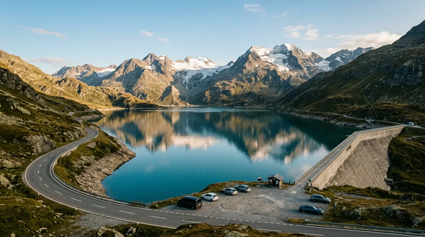
The Bielerhöhe at the summit is the centerpiece. The Silvretta reservoir fills a high valley between the Silvretta and Vermunt mountain groups, its water a deep blue-green that photographs well in any light. The reservoir dam is accessible on foot, and walking across it gives you the pass-from-above perspective that most passes deny you — you are standing higher than the road, looking down at the hairpins that brought you here.
The pass also connects two distinct valleys. The Montafon (east) is a broad, prosperous Vorarlberg valley with ski resorts and well-maintained infrastructure. The Paznaun (west) is Tyrol — narrower, higher, and with the Arlberg ski resorts at its western end. Driving the Silvretta feels like a passage between two different versions of the Austrian Alps.
And it costs less than the Grossglockner. The Silvretta toll is approximately EUR 16.50 per car (2025), making it considerably cheaper for what we consider a comparable experience. This is not a recommendation to skip the Grossglockner — both are worth driving. But if your trip allows only one Austrian toll road, the Silvretta offers the better ratio of scenery to fellow tourists.
Which direction to drive
East to west. Start in Partenen (1,051m, Montafon) and finish in Galtür (1,584m, Paznaun).
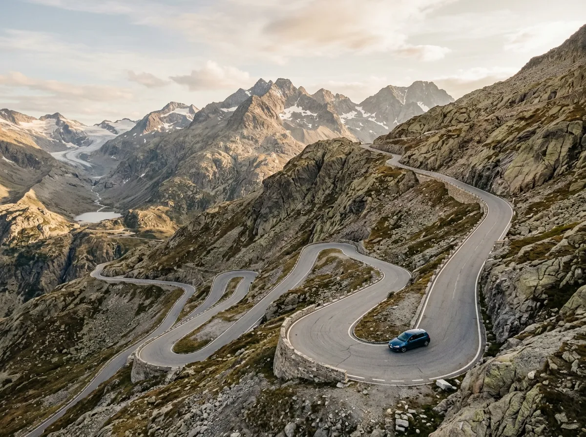
The eastern ascent from Partenen is the steeper and more dramatic side, with the majority of the 32 hairpins concentrated in the first twelve kilometers. Climbing this side puts the hard work where your engine is helping rather than your brakes. The descent to Galtür on the western side is gentler, with longer curves and a more gradual gradient.
There is also a scenic argument. Climbing from Partenen, the Bielerhöhe reservoir appears as a sudden revelation after twelve kilometers of hairpin ascent through forest and bare rock. You work for the view, and the view rewards you. Descending from Galtür, the reservoir is your starting point — pleasant but not a revelation.
Kilometer by kilometer
Km 0-4: Partenen and the toll gate
Partenen sits at the bottom of the Montafon Valley, a small town that serves primarily as the gateway to the Silvretta road and the Vermunt hydroelectric complex. The toll gate is at the southern edge of town. Pay here (EUR 16.50 per car, 2025) and keep the receipt.
Above the toll gate, the road immediately begins to climb. The first kilometer includes two tight hairpins that serve as a preview — this eastern ascent means business from the start. The asphalt is good, the hairpins are well-banked, and the gradient settles into a steady 10-12% that will remain more or less constant until the summit.
Km 4-8: The Vermunt reservoir section
The road climbs past the Vermunt Stausee, a lower reservoir in the Silvretta hydroelectric system. The lake appears below and to the right, its water a dark blue-green in a setting of granite and sparse vegetation. A short tunnel and gallery section passes through the cliff above the lake — the rock windows offering framed views of the water below.
This section includes several hairpins that stack tightly above each other, visible from below as a road that seems to be climbing itself. The gradient is demanding but the road quality compensates — every hairpin is properly surfaced and wide enough for two cars to pass without concern.
Km 8-12: Above the tree line
Above the Vermunt, the landscape transitions to high alpine: bare rock, scree slopes, and patches of late-season snow in sheltered gullies. The hairpins continue at regular intervals, each one folding back on the one below and adding another twenty meters of altitude. The views back down to the Montafon open progressively — on clear days, you can see the Rhine Valley beyond the valley mouth.
The final approach to the Bielerhöhe is through a landscape of polished granite and sparse grass. The air is noticeably thinner at 2,000 meters, though not enough to affect performance unless you or your car have altitude sensitivities. (The car might. We once drove a turbocharged diesel that was distinctly unhappy above 1,800 meters. Naturally aspirated engines tend to cope better, though with slightly reduced power.)
Km 12-14: Bielerhöhe summit
The Bielerhöhe (2,032m) is less a summit and more a high valley. The Silvretta reservoir fills the valley floor, with the dam at the northern end and the road running along the eastern shore. There is a hotel (the Silvrettahaus), a restaurant, parking, and a small chapel — the infrastructure of a place that expects visitors but not crowds.
Walk across the dam. This takes fifteen minutes and gives you the definitive Silvretta photograph: the reservoir stretching south toward the Silvretta glacier group, with the Piz Buin (3,312m, the highest peak in Vorarlberg) visible on clear days. The water color varies from turquoise to deep blue depending on light and season, and the reflection of the surrounding peaks turns the reservoir into a natural mirror.
The Silvrettahaus restaurant serves Austrian standards (Wiener Schnitzel, Kaiserschmarrn, Germknödel). The quality is above average for a mountain restaurant, and the terrace overlooks the lake. This is a lunch stop, not a quick coffee.
Km 14-22: Western descent to Galtür
The western side of the Silvretta is a different character. Where the east is hairpin-dense and dramatic, the west descends in longer, sweeping curves through the Paznaun Valley. The gradient is gentler (6-8% versus 10-12% on the east), and the road opens up into wider valley terrain more quickly.
The descent passes through patches of larch forest and alpine meadow, with views down to the Paznaun Valley and, eventually, to Galtür. The town is a ski resort in winter and a quiet hiking base in summer, with hotels, fuel, and a memorial museum dedicated to the devastating 1999 avalanche that killed 31 people in the town. The memorial is sobering and well-done, and a reminder that these valleys are not merely scenic — they are places where mountain hazards are a daily reality.
Practical information
| Detail | Information |
|---|---|
| Opening dates | Typically early June to late October |
| Toll | EUR 16.50 per car (2025). Motorcycles EUR 12.00. |
| Gate hours | Jun-Sep: 6:00-21:00. May/Oct: 8:00-18:00. |
| Fuel | Partenen (east), Galtür or Ischgl (west). None on the pass. |
| Parking | Free at Bielerhöhe and several pull-offs. All included in toll. |
| Best time of day | Morning for the reservoir in flat light; afternoon for dramatic shadows on the eastern hairpins |
| Avoid | Nothing specific — traffic is rarely an issue. Weekends are busier but still manageable. |
| Length | 22 km Partenen to Galtür |
| Drive time | 40-55 minutes without stops |
| Facilities | Hotel and restaurant at Bielerhöhe. Small shop. No other facilities on the pass. |
Combine with nearby passes
Silvretta + Arlberg: From Galtür, continue west through the Paznaun to St. Anton, then over the Arlberg Pass (1,793m) to Lech or Zürs. This adds a gentler but scenically stunning pass to your day.
Silvretta + Flexenpass: The Flexenpass (1,773m) connects Lech to Stuben am Arlberg through a spectacular cliff-hugging road with tunnels and gallery sections. Combined with the Silvretta, it makes a full day of Vorarlberg/Tyrol driving.
The Trilogy: The Silvretta is the final day of the Tyrol Pass Trilogy, following the Grossglockner and Gerlos. Three days, three toll roads, three very different Austrian alpine experiences.
Cross-border: From Galtür, the road continues west through the Paznaun to Landeck, from where you can reach Innsbruck (1 hour) or continue to Switzerland via the Inn Valley and the Reschenpass.
The Silvretta does not try to compete with the Grossglockner. It does not need to. Where the Grossglockner is a production — toll gates, visitor centers, million-strong annual audience — the Silvretta is a quiet conversation between the road and the mountain. You pay less, you share less, and you leave with the particular satisfaction of having driven something excellent that most people drive past on their way to something more famous. We have done both many times. We recommend both. But when someone asks us which Austrian pass we would drive tomorrow if we could only drive one, we hesitate for exactly one second before saying Silvretta.