Atlantic to Summit — Sea Level to Cloud Level
The Atlantic Road begins at sea level. Not metaphorical sea level – actual sea level, with the Atlantic Ocean breaking against the bridge abutments and salt spray coating your windscreen on a windy day. The road crosses eight bridges over open ocean, hopping from island to island, rising and dipping in graceful arcs that look, from the right angle, like the road itself is breathing with the swells.
Three hundred and ten kilometers later, Trollstigen ends at 858 meters above sea level, in a landscape of bare rock and persistent cloud, where the air is thin enough that you notice it and cold enough that you zip your jacket even in July. Between those two points, you pass through everything Norway has: ocean, farmland, fjords, river valleys, alpine tundra, and the kind of mountain scenery that makes the rest of Scandinavia look flat.
This is the Atlantic to Summit route – three days from Kristiansund to Andalsnes, from the horizontal to the vertical, from a road built across the sea to a road built up a cliff. It is shorter and gentler than our Fjord Vertigo Loop, making it ideal for drivers who want to experience Trollstigen without committing to four days and three mountain passes. The difficulty rating is 3 – confident driver territory – because while the Atlantic Road requires no particular skill and Trollstigen is manageable with care, the combination of exposed coastal driving and mountain hairpins covers enough variety to keep you engaged for every one of the 310 kilometers.
Route overview
| Detail | Info |
|---|---|
| Start | Kristiansund |
| End | Andalsnes (or loop back to Kristiansund via Molde) |
| Total distance | ~310 km |
| Driving days | 3 |
| Key roads | Atlantic Road (Atlanterhavsvegen), Rv 64, E39, Rv 63 (Trollstigen) |
| Difficulty | 3/5 (Confident driver) |
| Season | Year-round for Atlantic Road; May-October for Trollstigen |
| Ferries | 1 (optional: Eidsdal-Linge if approaching Trollstigen from west) |
The route runs roughly south-southeast from Kristiansund along the coast, then turns inland toward the mountains. The transition from coastal to alpine happens gradually but unmistakably – the flat, windswept islands give way to river valleys, the valleys narrow, the mountains rise, and suddenly you are at the base of Trollstigen looking up at a cliff face with a road on it.
Day by day
Day 1: Kristiansund and the Atlantic Road (30 km of driving, full day of experience)
Fly into Kristiansund or drive up from Bergen or Trondheim. Kristiansund is a small city spread across four islands, connected by bridges and a subsea tunnel. It is functional rather than beautiful, but the harbor has good seafood restaurants and the proximity to the Atlantic Road makes it the logical starting point.
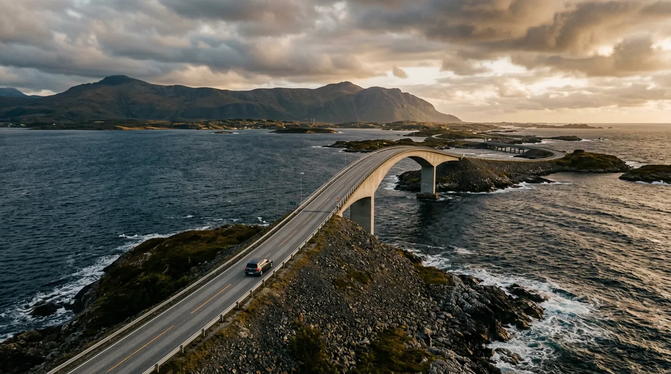
The Atlantic Road (Atlanterhavsvegen) is only 8.3 kilometers long. This fact is important because it will take you much longer than 8.3 kilometers suggests. You will stop. You will get out. You will photograph the same bridge from six different angles. You will stand on the rocks beside the road and watch the ocean crash against the causeway. On a calm day, the Atlantic Road is beautiful. On a stormy day – and the best day to drive the Atlantic Road is a stormy one – it is among the most exhilarating stretches of road on the planet.
The route from Kristiansund to the Atlantic Road runs via Averoy, an island connected to the mainland by the Atlanterhavstunnelen (subsea tunnel, toll ~90 NOK). The tunnel delivers you to Averoy’s green, windswept landscape, and from there signs for Atlanterhavsvegen guide you to the start of the road.
The road itself crosses eight bridges between the islands of Averoy and the mainland at Karvag. The most famous bridge is Storseisundet – a deliberately dramatic arc that, from certain angles, appears to climb to a peak and then vanish, as if the road simply ends in mid-air. This optical illusion has made Storseisundet one of the most photographed bridges in the world. In reality, the road curves sharply at the top and descends the other side, but the first time you drive it, your brain briefly disagrees with this assessment.
In storm conditions, waves break over the road surface. This is not a defect – it is a feature. The Atlantic Road was designed for this environment, and the bridges are strong enough to handle significant wave action. Your car, however, was not designed for it, so if waves are breaking over the road, slow down, turn on your headlights, and enjoy the fact that you are driving across the ocean in a storm. It is the kind of experience that sounds irresponsible when described but feels perfectly natural when it is happening.
After crossing the Atlantic Road, spend the rest of the day exploring the coastal area. The village of Bud, south of the road, has a small World War II coastal fortress museum and a harbor where fishing boats still operate. The coastline between Bud and the Atlantic Road is wild, rocky, and persistently beautiful in the way that exposed Atlantic coastlines are.
Overnight: Averoy or Bud. Several guesthouses, a few Airbnbs, one or two hotels. Book ahead in summer – the Atlantic Road attracts visitors, and accommodation on the coast is limited.
Day 2: Coast to mountains via Molde (160 km, 4-5 hours)
The transition day. You leave the coast and drive inland, watching the landscape transform from maritime to alpine over the course of a few hours.
From Bud or Averoy, head east toward Molde on the E39. Molde bills itself as the “City of Roses” (Rosenes By), which sounds improbable for a Norwegian coastal town until you visit in summer and realize that the Gulf Stream creates a microclimate mild enough for gardens. The Romsdalsfjord stretches out below the town, and from the Varden viewpoint above the city, you can see 222 snow-capped mountain peaks in a single panorama. On a clear day. On a cloudy day, you can see about twelve, which is still more than most places.
From Molde, continue east on the E39 toward Andalsnes. The road follows the Romsdalsfjord and then the Rauma river valley, and the mountains close in progressively. By the time you reach Andalsnes, you are in a deep glacial valley surrounded by peaks that rise to 1,800+ meters. The vertical rock face of Trollveggen (the Troll Wall) – at 1,100 meters, the tallest vertical rock face in Europe – is visible from the road. You cannot miss it because it is literally a wall of rock that fills the entire windscreen.
Andalsnes is a small town that exists primarily as a gateway to Trollstigen and the surrounding mountains. The Norwegian Mountain Centre (Norsk Fjellsenter) is worth an hour – interactive exhibits on Norwegian mountain history, geology, and the engineering of mountain roads.
If you want to split the driving further, stay in Andalsnes tonight and save Trollstigen for morning. This is our recommendation. Approaching Trollstigen fresh, early, with a full tank and an empty road, is worth more than arriving tired in the afternoon.
Overnight: Andalsnes. More accommodation options than you might expect for a town this size, including the excellent Andalsnes Hostel and several hotels. The Rauma river running through town is famous for salmon fishing, though you will need a permit and more patience than we have.
Day 3: Trollstigen and beyond (120 km, 3-4 hours including Trollstigen)
This is the summit day. The entire route has been building toward this – from sea level to cloud level, from horizontal bridges to vertical hairpins, from ocean spray to mountain mist.
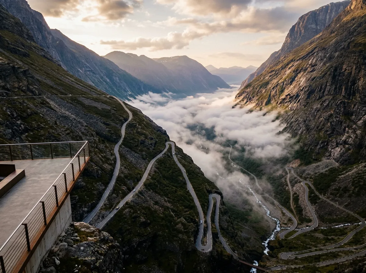
Leave Andalsnes by 07:00 at the latest. The drive to the base of Trollstigen is approximately 15 km south on the Rv 63, through the Isterdalen valley. The valley narrows as you approach, the mountains rise on both sides, and Stigfossen waterfall comes into view – a 320-meter white line drawn down the cliff face with a road zigzagging up beside it.
Trollstigen (detailed guide: /norway/trollstigen). Eleven hairpins, 858 meters, 5.6 km of climbing road with a waterfall crossing and summit viewing platforms. Drive south to north. Allow 30-40 minutes for the climb, 30+ minutes at the summit.
At the summit, you have arrived. Sea level to 858 meters in three days and 310 kilometers. Stand on the viewing platform. Look down at the valley. Look back toward the direction you came from – somewhere over those mountains is the ocean you drove across two days ago. The horizontal and the vertical, connected by this road and the roads that led you here.
After Trollstigen, you have three options:
-
Continue to Geiranger (30 km). The road north from the Trollstigen summit descends to Geirangerfjord, one of the most famous fjords in the world. The Ornesvingen (Eagle’s Bend) viewpoint above Geiranger offers a view of the fjord, the cruise ships, and the Seven Sisters waterfall. From Geiranger, you can loop back toward Molde via ferry or continue into the mountains.
-
Return to Andalsnes and drive to Kristiansund (180 km). Close the loop by driving back to your starting point. This takes 3-4 hours on the E39 via Molde.
-
Continue south toward Bergen or Stavanger, connecting to our Fjord Vertigo Loop for a longer trip that adds Lysevegen and Stalheimskleiva.
Which car to rent
The Atlantic to Summit route is less demanding than the Fjord Vertigo Loop and works fine with almost any car. The Atlantic Road is a normal two-lane highway (just over ocean), and Trollstigen, while steep and narrow, is well-surfaced and manageable in anything with reasonable brakes.
That said, a manual gearbox makes Trollstigen more enjoyable, and a compact car is easier to maneuver on the hairpins. Our preference: something like a Volkswagen Polo, Mazda 2, or Toyota Yaris – small, light, responsive. If you are bringing passengers and luggage, a Golf or Focus-sized car is fine.
Rent from Kristiansund, Molde, or Alesund. Kristiansund has fewer agencies but removes the need for a transfer drive. Molde and Alesund have more options.
Practical information
| Detail | Info |
|---|---|
| Total cost estimate | Fuel ~1,200 NOK, tolls/tunnels ~300 NOK, accommodation ~2,000-3,500 NOK (2 nights), food ~1,500 NOK |
| Speed limits | 80 km/h on most roads, 50-60 km/h in towns, 30 km/h on Atlantic Road when windy |
| Best months | June-August (Trollstigen open, longest daylight, warmest) |
| Shoulder season | May and September (Trollstigen may be open – check vegvesen.no; Atlantic Road is year-round) |
| Weather | Coastal: windy, rain likely. Mountain: cooler, possible cloud cover on summit. Pack layers. |
| Mobile coverage | Good throughout, except some dead spots in the Rauma valley |
| Emergency | 113 (medical), 112 (police) |
Why this route works
The Atlantic to Summit route is built on contrast. The Atlantic Road is horizontal – bridges spanning flat water, the road skimming the ocean surface. Trollstigen is vertical – hairpins climbing a cliff face into the clouds. Between them, the landscape rotates gradually from one axis to the other, and the drive itself becomes a physical experience of Norway’s extremes.
It is also, at three days and 310 km, manageable. You do not need to rush. Each day has a clear focus – the coast, the transition, the mountain – and enough time for stops, meals, and standing by the roadside watching weather systems approach from the Atlantic. In a country where the weather is half the experience, having time to stand still is not a luxury. It is the point.
Individual pass guides
- Trollstigen – 11 hairpins, 858m, the flagship Norwegian mountain pass
For the full western Norway experience including Lysevegen and Stalheimskleiva, see the Fjord Vertigo Loop.
For all Norwegian mountain roads, see the Norway hub.