Stalheimskleiva — Downhill Only
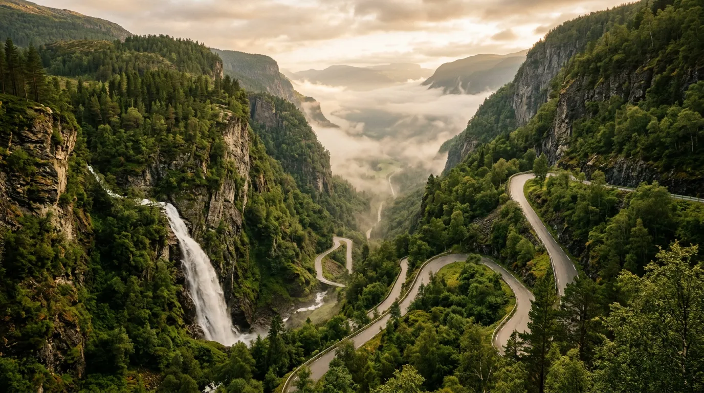
There is a sign at the top of Stalheimskleiva that says 18%. Not “up to 18%” or “maximum gradient 18%.” Just 18%, stated flatly, like a diagnosis. Below the sign, the road drops away from the plateau and disappears around the first hairpin bend into a canyon that looks, from up here, like something that should have a waterfall in it instead of a road. It does have a waterfall in it. Two, in fact. The road goes between them.
We sat at that sign for several minutes the first time, engine idling, foot firmly on the brake, looking at the first few meters of visible road and trying to calculate what 18% actually means in practical terms. What it means is this: for every 100 meters you travel forward, you drop 18 meters. That is roughly the height of a six-story building. The road does this for 1.5 kilometers. The math is not comforting.
Stalheimskleiva is one-way, downhill only. This is not a convention or a suggestion – it is a regulation, enforced because the road is too steep and too narrow for two-way traffic and because asking anyone to drive up an 18% gradient on a single-lane road with 13 hairpin bends and no guardrails would constitute something close to a public health hazard. You go down. You go slowly. You do not stop paying attention for even a moment. And when you reach the bottom, you sit in the car and breathe.
Why drive Stalheimskleiva
Because it is there. Because it is the steepest road in northern Europe that is still open to regular traffic. Because the 1.5 kilometers of Stalheimskleiva contain more genuine fear per meter than any other paved road we have driven, and fear – the useful kind, the kind that sharpens your senses and makes you grip the steering wheel with both hands at ten and two – is an underrated component of a good driving experience.
Stalheimskleiva was the main road between Gudvangen and Voss until 1991, when the Stalheimstunnelen was built to bypass it. Before the tunnel, everything that needed to travel between these two towns – cars, buses, delivery trucks, livestock trailers – went down Stalheimskleiva. Or up it. In both directions. We have spoken to Norwegians old enough to remember two-way traffic on this road, and they describe it the way combat veterans describe combat: with a certain detached calm that does not entirely conceal the lingering horror.
The tunnel has made Stalheimskleiva optional, and most traffic takes the tunnel. This means the old road is quiet – sometimes completely empty – which is ideal because the last thing you want on an 18% downhill with 13 hairpins is company.
The road is also beautiful, in the way that dangerous things are sometimes beautiful. The Stalheimskleiva gorge is narrow, lush, and vertical. Two waterfalls – Stalheimsfossen (126m) and Sivlefossen (142m) – cascade down the canyon walls on either side of the road. The vegetation is almost tropical in summer: ferns, moss, birch trees growing at impossible angles from the rock, everything dripping with moisture. On a misty day, the gorge fills with cloud and the road descends into it like a staircase into fog.
Which direction to drive
Down. There is no choice. Stalheimskleiva is one-way downhill from May to September (when it is open to traffic). The road technically exists in the uphill direction, but it is closed to vehicles and used only by the very occasional pedestrian or cyclist with a death wish and excellent quadriceps.
You approach from the E16 highway at the top of the gorge, turning off at the clearly signed junction near the Stalheim Hotel. The Stalheim Hotel, incidentally, has one of the finest views in western Norway – the terrace looks straight down the canyon, with both waterfalls visible and the Naerodalen valley stretching toward Gudvangen below. Having a coffee on this terrace before attempting the descent is either excellent preparation or terrible psychology, depending on your disposition.
The descent
The top (0-0.3 km): gravity announces itself
The first hundred meters from the junction are deceptively gentle – a slight downhill on a narrow road that could be any rural Norwegian lane. Then the road turns a corner and drops.
There is no gradual transition. The gradient goes from manageable to alarming in the space of a single car length. Your car will want to accelerate. Do not let it. First gear. Engine braking. Foot hovering over the brake, not pressing constantly but ready. Constant brake pressure on a gradient like this will overheat your pads within minutes, and the road is too steep and too winding for ABS to be your primary safety system.
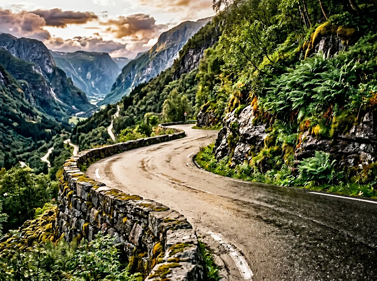
The first hairpin arrives almost immediately. It is tight – full lock, both ways – and the road surface is rough. There are no guardrails on this turn. There is a low stone wall about knee-height. Beyond the wall is the canyon. Do not look over the wall while driving.
Hairpins 2-6 (0.3-0.7 km): the steep section
This is the steepest section of the steepest road in northern Europe, which makes it, by definition, among the steepest stretches of paved road you will ever drive. The gradient here is a consistent 18%, and on some turns it may exceed that. Your brake pedal will feel spongy if you are riding it. Do not ride it. Gear down. Let the engine do the work.
The hairpins come in rapid succession. Turn, straighten for perhaps 30 meters, turn again. The road surface is wet – it is almost always wet, because the waterfalls create a permanent mist in the canyon and the sun rarely penetrates to road level. The combination of steep gradient, wet surface, tight turns, and minimal barriers creates a driving environment that demands total concentration.
The smell of hot brakes is a warning that you are using them wrong. On Stalheimskleiva, we use first gear the entire way and touch the brake pedal only at the tightest hairpins. If you can smell your brakes, stop at the next flat spot (there are very few), let them cool for five minutes, and then proceed in a lower gear. Brake fade on an 18% gradient is not something you want to experience firsthand.
Between hairpins four and five, Stalheimsfossen is directly beside the road. In heavy flow (spring meltwater, or after rain), spray reaches the road surface. The combined effect of waterfall spray, canyon mist, and steep gradient means you will be driving through something closer to a shower than a road. Wipers on. Fog lights on if you have them. Maintain first gear.
Hairpins 7-10 (0.7-1.1 km): the canyon narrows
The canyon walls close in and the road passes through the narrowest section. The vegetation here is extraordinary – the combination of moisture, shelter, and south-facing rock creates a microclimate that supports ferns and mosses more typical of a greenhouse than a Norwegian canyon. In summer, the foliage hangs over the road and the light turns green.
The road surface improves slightly in this section – smoother asphalt, better drainage – but the gradient remains extreme. Hairpin eight is the tightest on the descent, requiring a three-point turn in some vehicles. If you are driving anything longer than a standard car, hairpin eight will require patience and spatial awareness.
Hairpins 11-13 (1.1-1.5 km): the relief
The gradient begins to moderate. Not dramatically – it is still steep by any normal standard – but the reduction from 18% to perhaps 12% feels like stepping off a treadmill. Your car relaxes. Your brakes cool. The canyon opens slightly, and the Naerodalen valley appears below.
Hairpin 13 is the last. The road straightens, widens, and joins the valley road toward Gudvangen. You are at the bottom. The entire descent has taken perhaps ten to fifteen minutes, depending on your speed and how many times you stopped to collect yourself. It felt longer.
Pull over at the first opportunity and get out of the car. Check your brakes – touch a wheel hub carefully to feel for heat. Look back up at the canyon. From down here, the road is invisible. You cannot see where you have been. The canyon simply rises vertically, with waterfalls pouring down both sides, and the idea that someone built a road up that cliff face seems even more absurd from below than it does from above.
Practical information
| Detail | Info |
|---|---|
| Road designation | Former E16, now county road (unsigned number) |
| Opening dates | Typically May to September (check locally) |
| Direction | Downhill only (one-way, top to bottom) |
| Toll | Free |
| Fuel | Voss (east) or Gudvangen (bottom) |
| Parking | Small pullout at the top near Stalheim Hotel; valley parking at bottom |
| Best time | Morning for softer light in the canyon; any dry day |
| Avoid | Heavy rain (road becomes a waterfall); fog (visibility drops to near zero) |
| Vehicle restrictions | No motorhomes or trailers. Check current restrictions at stalheim.com |
| Brakes | Check brake pad thickness before attempting. Not a joke. |
What car to bring
This matters more on Stalheimskleiva than on almost any other road we cover. You want:
- Manual gearbox – essential for engine braking. An automatic will work, but manual gives you direct control of engine speed.
- Good brakes – check them before you go. If the rental has thin pads or spongy pedals, take the tunnel instead.
- Short wheelbase – the hairpins are tight. A compact car is ideal. An SUV will work but will require more maneuvering.
- Avoid – anything with a trailer, anything over 5 meters long, anything with questionable brakes.
The psychological dimension
We do not usually write about the emotional experience of driving a road, but Stalheimskleiva warrants it. This road will make you nervous. It will make experienced mountain drivers nervous. The combination of extreme gradient, wet surface, tight hairpins, minimal barriers, and genuine exposure creates a sustained state of alertness that is, depending on your temperament, either deeply unpleasant or extraordinarily vivid.
We know drivers who have done Stalheimskleiva and described it as the highlight of their Norway trip. We also know drivers who have done it and described it as a mistake. The difference, in our experience, is not skill but disposition. If the idea of an 18% gradient with no guardrails excites you, this is your road. If it makes you uneasy even reading about it, take the tunnel. The tunnel is perfectly fine. There is no shame in the tunnel.
But if you do drive Stalheimskleiva, you will not forget it. We guarantee that.
Combine with nearby passes
Stalheimskleiva is the climax of our Fjord Vertigo Loop – the final descent on a four-day route that also includes Trollstigen and Lysevegen. After the controlled drama of those two roads, Stalheimskleiva provides the exclamation mark.
The road also connects to the Naerodalen valley, which leads to Gudvangen and the Naeroyfjord (UNESCO-listed), making it easy to combine with a fjord cruise. Several operators run boats from Gudvangen to Flam, and from Flam you can take the Flamsbana railway – one of the steepest standard-gauge railway lines in the world – back toward Voss.
For the full listing of Norwegian mountain roads, see the Norway hub.