The Fjord Vertigo Loop
Bergen to Bergen in four days, 420 kilometers, three mountain roads, two ferry crossings, and one moment on Stalheimskleiva where you will seriously question why you listen to people who write mountain pass guides on the internet. This is the Fjord Vertigo Loop – our route through the most vertical landscape in western Norway, linking three roads that have almost nothing in common except altitude change and the fact that each one, in its own way, will make you grip the steering wheel harder than you expected.
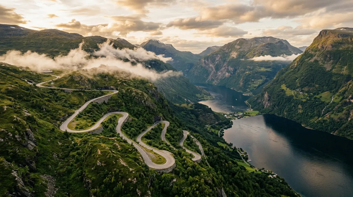
Trollstigen is the famous one – 11 hairpins up a waterfall-crossed cliff face, tour buses, viewing platforms, the full Norwegian Scenic Routes experience. Lysevegen is the hidden one – 27 hairpins above Lysefjord that nobody outside Rogaland talks about but that we think is the better drive. Stalheimskleiva is the terrifying one – 18% gradient, one-way downhill, 13 hairpins, no guardrails, and a canyon that looks like it was designed to punish overconfidence.
Three roads, three different flavors of mountain driving, connected by some of the best fjord scenery in Scandinavia and by a ferry system that actually works. We have driven this loop twice – once clockwise, once counter-clockwise – and have settled on the counter-clockwise direction described here, because it saves Stalheimskleiva for last, and because ending a road trip with Stalheimskleiva is like ending a meal with espresso: sharp, concentrated, and impossible to forget.
Route overview
| Detail | Info |
|---|---|
| Start / End | Bergen |
| Total distance | ~420 km (excluding ferries) |
| Driving days | 4 |
| Mountain passes | Trollstigen (858m), Lysevegen (740m), Stalheimskleiva (380m) |
| Ferry crossings | 2 (Eidsdal-Linge, Lauvvik-Oanes or Tau-Stavanger) |
| Difficulty | 4/5 (Mountain veteran) |
| Season | May-September (Trollstigen and Stalheimskleiva seasonal) |
| Fuel stops | Bergen, Valldal, Stavanger, Odda, Voss |
The route is counter-clockwise: Bergen north to Trollstigen, then south along the coast to Stavanger, east to Lysevegen, north to Stalheimskleiva, and back to Bergen. This sequencing builds intensity – Trollstigen is dramatic but manageable, Lysevegen is technically demanding but controlled, and Stalheimskleiva is the climactic descent that earns its difficulty-5 rating.
Day by day
Day 1: Bergen to Valldal via Trollstigen (240 km, 6-7 hours including Trollstigen and ferry)
Leave Bergen early. 06:00 if you can manage it, 06:30 at the latest. The drive north to Trollstigen takes approximately four hours without stops, and you want to arrive at the base of Trollstigen before 09:00, ahead of the tour buses. This is the single most important scheduling decision of the entire trip.
The route from Bergen follows the E39 north, then cuts inland on Rv 60 and Rv 15 toward Geiranger. The driving is fast and efficient – dual carriageway and well-maintained two-lane highway through a landscape of mountains, fjords, and rain. Western Norway gets 2,000-2,500mm of rain per year. Pack waterproofs. Accept wetness as a feature, not a bug.
At Eidsdal, you take the ferry across the Norddalsfjorden to Linge (runs every 30 minutes, takes 10 minutes, costs approximately 180 NOK for car and driver). From Linge, the road to Valldal runs along the fjord, and from Valldal you approach Trollstigen from the south.
Trollstigen (detailed guide: /norway/trollstigen). Drive it south to north. Eleven hairpins, 858 meters, Stigfossen waterfall crossing the road. Allow 30-40 minutes for the climb and 30 minutes at the summit viewing platforms. If the weather is clear, spend longer – the views from the glass-floored platform are among the most dramatic in Norway.
After Trollstigen, continue north briefly to the Ornesvingen viewpoint above Geirangerfjord if time allows (20-minute detour, spectacular fjord views), then backtrack south to Valldal for the night.
Overnight: Valldal. Small town with several guesthouses and a campsite. The Jordbaerstova (Strawberry Place) sells the best strawberries in Norway – Valldal strawberries are famous, and in June-July the roadside stands are piled with them. Buy a punnet. Eat them for dessert. You have earned fruit.
Day 2: Valldal to Stavanger (320 km, 7-8 hours with ferry)
The long day. Valldal to Stavanger is a significant drive – roughly 320 km depending on your ferry choice – and most of it is highway driving through beautiful but not hair-raising scenery. Think of this as the transfer day, the connective tissue that links Trollstigen in the north to Lysevegen in the south.
Take the E39 south from Valldal, following the coast through a series of tunnels, bridges, and fjord-side stretches. The Romsdalfjord and the approach to Molde offer fine views, and the Atlantic Road (Atlanterhavsvegen) is a short detour to the west if you have time and want to add another famous road to the trip. We recommend it – it is only 8 km of road, but those 8 km cross a series of low bridges over the open Atlantic in a way that feels like driving across the surface of the sea.
The drive south from Molde to Stavanger is long and includes at least one additional ferry crossing (depending on your exact route). The E39 is a good road but not a fast one – Norwegian speed limits top out at 110 km/h on motorways and drop to 80 km/h or less on most two-lane sections. Do not plan on averaging more than 60-70 km/h including ferry waits and rest stops.
Overnight: Stavanger. Norway’s oil capital is a proper city – good restaurants, a lively harbor area (Vagen), and the Old Town (Gamle Stavanger), which is 173 white-painted wooden houses from the 18th-19th century packed into a few steep streets. It is genuinely beautiful and worth an hour’s wander in the evening light. Eat fish. Stavanger does fish well.
Day 3: Stavanger to Lysevegen to Odda (180 km, 5-6 hours including Lysevegen)
The best driving day of the trip. Leave Stavanger in the morning and head for Lysevegen. The approach from Stavanger goes via Lauvvik or Forsand, depending on whether you take the ferry across to Lysebotn or drive the inland route.
We recommend the inland approach via Rv 13 to the base of Lysevegen, which puts you at the fjord-side start of the hairpin road. This way you climb west to east – the correct direction, as argued in our Lysevegen guide.
Lysevegen (detailed guide: /norway/lysevegen). Twenty-seven hairpins, 740 meters of elevation gain, Lysefjord visible below for the entire climb. Less famous than Trollstigen, arguably better as a driving experience. The rhythm of the hairpins – tighter, more frequent, more insistent – will feel different from yesterday’s Trollstigen. Where Trollstigen is a spectacle, Lysevegen is a conversation between you and the road.
At the top, decide whether to hike. The Kjerag trailhead is nearby (10-12 km round trip, 5-7 hours), and Preikestolen is visible across the fjord. If you hike, you will need to stay another night near the plateau. If not, continue east.
After Lysevegen, head north toward Odda via Rv 13 through the Roldal area. The road passes through lake-dotted highland terrain and descends into the Sorfjorden, a narrow arm of the Hardangerfjord. Odda itself is a small town at the fjord’s end, functional rather than picturesque, but it is well-positioned for tomorrow’s final stage.
Overnight: Odda. The town is the gateway to Trolltunga (Troll’s Tongue), another famous Norwegian viewpoint/hike. If you have the energy and an extra day, the hike is magnificent. Otherwise, eat, sleep, and prepare yourself for tomorrow.
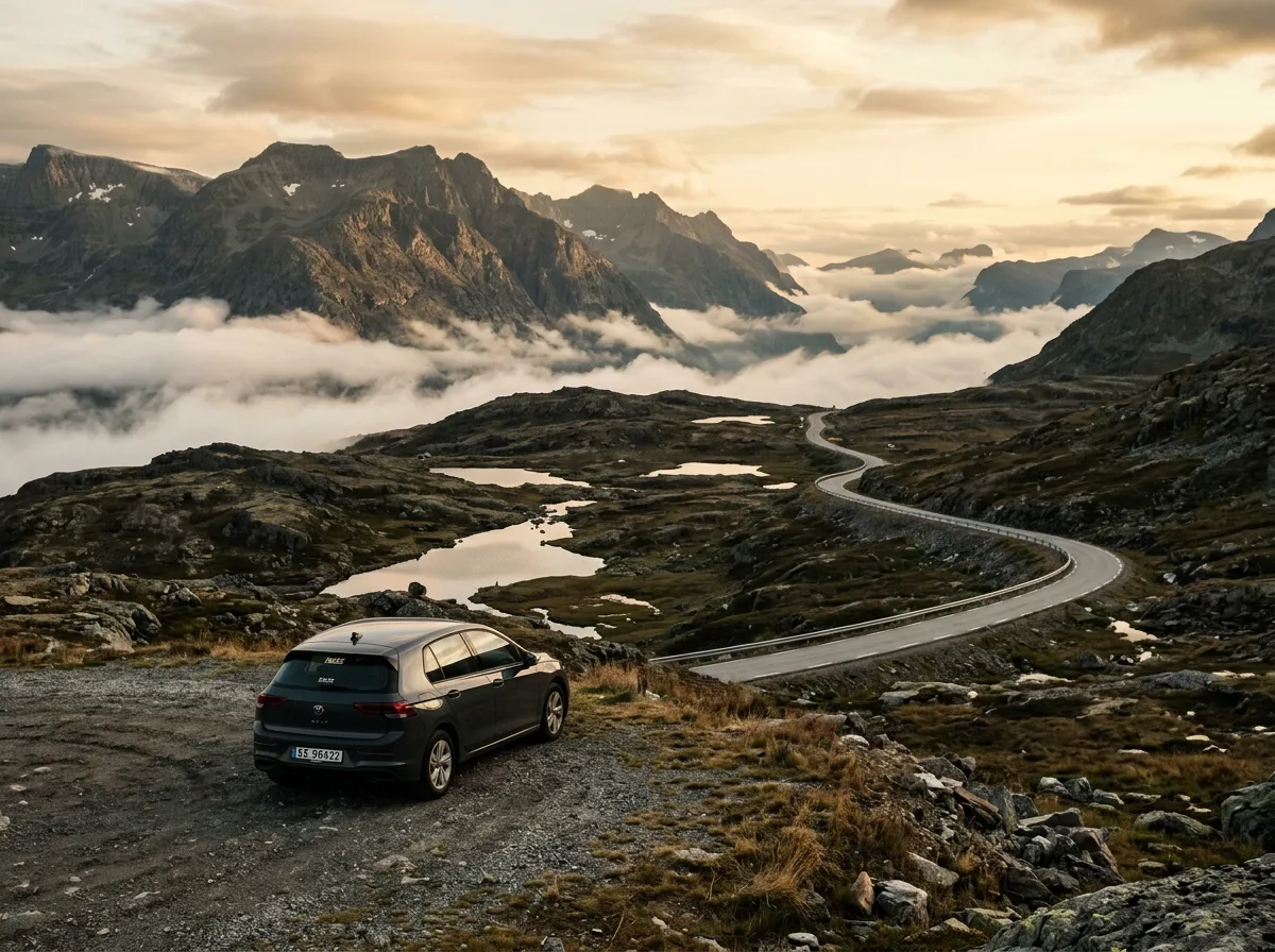
Day 4: Odda to Bergen via Stalheimskleiva (120 km, 3-4 hours including Stalheimskleiva)
The short day, and deliberately so. The drive from Odda to Bergen via Stalheimskleiva is only about 120 km, but Stalheimskleiva itself is an experience that benefits from not being rushed, and Bergen deserves at least an afternoon.
From Odda, drive north along the Sorfjorden and then east on the E16 toward Voss. The road follows the Hardangerfjord, one of Norway’s longest and deepest, and the scenery is dramatic in that uniquely Norwegian way where you stop noticing the waterfalls after a while because there is one every few hundred meters.
At the junction near Stalheim Hotel, turn off for Stalheimskleiva. Stop at the hotel terrace for coffee. Look down. Breathe.
Stalheimskleiva (detailed guide: /norway/stalheimskleiva). Eighteen percent. One-way downhill. Thirteen hairpins. No guardrails worth the name. This is the exclamation mark at the end of the trip – 1.5 kilometers of road that you will remember more vividly than the other 418 combined.
Read our full guide before attempting it. Use first gear for the entire descent. Do not ride the brakes. Do not look over the stone walls. When you reach the bottom, pull over and check your brake temperature. Then drive to Bergen in a state of calm satisfaction, knowing that you have just completed the most intense 1.5 km of mountain driving in northern Europe.
Return to Bergen via the E16 and E39. The drive from Gudvangen (at the bottom of Stalheimskleiva) to Bergen takes approximately two hours through the Naerodalen valley and past the Naeroyfjord, which is UNESCO-listed and visible from the road. Arrive in Bergen by mid-afternoon. Walk the Bryggen wharf. Eat seafood at the Fish Market. Consider that four days ago you left this city and have since driven 420 km, climbed 51 hairpins, crossed two fjords by ferry, and descended one of the steepest roads on the continent. Beer is appropriate.
Which car to rent
For this loop, you want a compact car with a manual gearbox. The reasons are specific to each road:
- Trollstigen needs good engine braking for the descent (if you overshoot and need to come back) and the hairpins require a short turning circle.
- Lysevegen rewards a responsive throttle and precise steering – the rapid-fire hairpins flow better in something nimble.
- Stalheimskleiva demands engine braking. An automatic will work, but first gear in a manual gives you direct, immediate control of your descent speed. On an 18% gradient, this is not a luxury.
A Volkswagen Golf, Ford Focus, Skoda Octavia, or similar is ideal. Avoid anything longer than 4.5 meters (the hairpins on Stalheimskleiva and Lysevegen will punish length) and anything with automatic-only transmission if you have the option.
Rent from Bergen or Stavanger. Bergen has more agencies and better availability.
Practical information
| Detail | Info |
|---|---|
| Total cost estimate | Fuel ~2,000 NOK, ferries ~500 NOK, accommodation ~3,000-5,000 NOK (3 nights), parking ~500 NOK |
| Toll roads | Several AutoPASS toll stations on the E39; car rental agencies handle billing |
| Speed limits | 80 km/h most two-lane roads, 110 km/h on motorway sections, 60 km/h in towns |
| Best time | Mid-June to early September (all three roads open, longest daylight) |
| Alternative season | May or late September (Trollstigen and Stalheimskleiva may open/close – check vegvesen.no) |
| Ferry booking | Not usually necessary – pay on arrival. Check timetables at norled.no or fjord1.no |
| Emergency | 113 (medical), 112 (police), 110 (fire). Mountain rescue: Red Cross Hjelpekorps |
Weather and contingency
Western Norway is wet. You will encounter rain on at least two of the four days – statistically, on three. This is not a problem for the driving (the roads are designed for rain) but it affects visibility on the mountain passes. If Trollstigen is in cloud, consider waiting. The views are the point, and there are no views in cloud.
If Stalheimskleiva is in heavy rain, consider the tunnel. We have driven the descent in moderate rain and it was fine – the road drains adequately and the speed is so low that traction is not an issue. In heavy, sustained rain, the waterfalls in the canyon overspill and the road becomes a secondary waterfall. At that point, the tunnel is the sensible choice. We have never written that sentence about any other road.
Individual pass guides
Each of the three passes on this route has a detailed standalone guide:
- Trollstigen – 11 hairpins, 858m, the famous one
- Lysevegen – 27 hairpins, 740m, the hidden one
- Stalheimskleiva – 13 hairpins, 380m, the terrifying one
For all Norwegian mountain roads, see the Norway hub.