Trollstigen — The Troll’s Ladder
The first time we drove Trollstigen, we did it wrong. We came from the north, descending into the valley at noon on a Wednesday in July, and spent forty-five minutes reversing into passing places while a procession of tour buses ground upward toward us, their wing mirrors close enough that we could have reached out and adjusted them. One driver waved apologetically. Another did not wave at all. We arrived at the bottom with sore shoulders, a new understanding of what “single lane with passing places” actually means when the other vehicle weighs twelve tons, and a firm conviction that we would never make that mistake again.
We came back three weeks later. South to north. Seven in the morning. The road was ours. The waterfall roared beside us. The hairpins unfolded one after another, each revealing more of the valley below until it seemed impossible that we had been down there just minutes earlier. At the summit, we stood on the glass-floored viewing platform with precisely two other people and watched clouds form in the valley we had just climbed out of. That was when we understood why Trollstigen is the most famous mountain road in Scandinavia and why most people who drive it once come back to drive it again.
Why drive Trollstigen
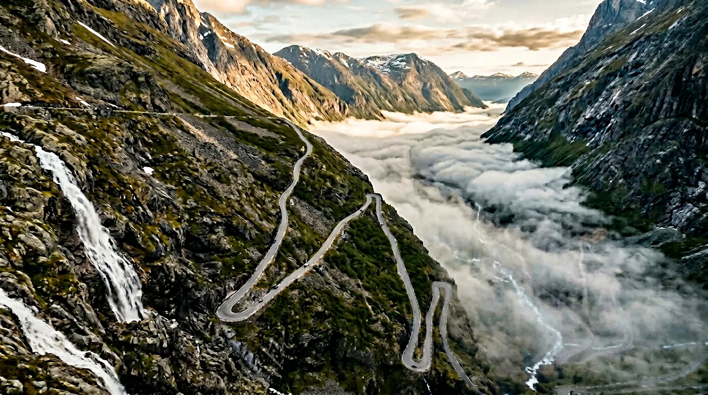
Trollstigen is not the highest pass in Norway. It is not the longest, not the steepest, not the most technically demanding. What it is, and what makes it extraordinary, is concentrated. In just 5.6 kilometers of climbing road, it packs eleven hairpin bends, a 10% average gradient, a waterfall that crashes directly across the road surface in heavy rain, and views that would justify the drive even if the road itself were a boring dual carriageway.
The Trollstigen road – Trollstigvegen, formally National Tourist Route 63 – was completed in 1936 after eight years of construction. Building a road up this mountainside was considered impossible for decades. The valley wall rises almost vertically, the Stigfossen waterfall drops 320 meters through the gap where the road needed to go, and the rock is a mix of gneiss and granite that fights back against every drill and blast. The engineers solved it by building the road in a series of tight switchbacks that zigzag up the cliff face, each one a shelf carved from the mountainside, with stone bridges crossing the waterfall at two points.
The result is a road that feels less like infrastructure and more like an act of stubbornness. Every hairpin is a declaration that someone, at some point, looked at this cliff and decided to build a road on it anyway. The fact that they succeeded is the reason tour buses now queue to make the same journey, and the reason you should get there before the buses do.
Which direction to drive
South to north. This is not a suggestion – it is the correct answer, and we will argue the point with anyone.
Driving south to north means you start in the Isterdalen valley at the base of the wall and climb upward. This gives you three crucial advantages:
You see what is coming. The hairpins are visible above you, climbing the cliff face like a concrete staircase. You can see the Stigfossen waterfall cascading down from somewhere near the top. You can see the other vehicles on the road above, which means you know exactly when a tour bus is heading toward you and can plan accordingly. Descending from the north, you see nothing until you are already committed to each turn.
The dramatic reveal works in your favor. Each hairpin lifts you higher and opens a wider view of the valley below. The experience builds. By hairpin seven, you can see the river far below as a thin line. By hairpin nine, you can see the mountains across the valley. By the summit, you can see the fjord in the distance. Going the other way, you start with the best view and watch it shrink – an anticlimax by any measure.
Tour buses climb south to north. This matters enormously. If you are going in the same direction as the buses, you can pass them on the approach road and stay ahead. If you are descending while they are climbing, you are the one who must reverse into passing places. On a single-lane road with a sheer drop on one side, reversing uphill while a bus waits below is an experience we recommend precisely once, for educational purposes.
The only argument for north to south is that you get to see the famous approach view – the road zigzagging up the cliff face in front of you. It is admittedly spectacular. But you can get that view by walking to the lower viewpoint near the base of the road. You do not need to drive the wrong way for it.
Kilometer by kilometer
The approach from Valldal (0-12 km before the climb)
Most drivers coming from the south will approach via Valldal, a small town on the Norddalsfjorden. The road from Valldal to the base of Trollstigen runs through the Isterdalen valley, and it is beautiful in the way that Norwegian valleys are routinely beautiful – green, steep-sided, with a river running through it and small farms tucked against the hillsides. The valley narrows as you head east, and the mountains close in overhead.
About 5 km before the hairpins begin, you will see the first signs for Trollstigen. There is a tourist center at the base with parking, toilets, a cafe, and a gift shop selling troll figurines. You can stop here, but we prefer to push through and stop at the top instead. The tourist center at the summit is better, and you will appreciate the coffee more after the climb.
The road at the base is still two lanes, but it narrows. You will start to see other vehicles – campervans pulling over to photograph the valley, motorcycles waiting in groups, tour bus drivers checking their mirrors one final time. There is a palpable sense of anticipation. Everyone here is about to do the same thing.
Hairpins 1-4: the opening moves (0-2 km)
The climb begins without ceremony. The road simply starts going up, the gradient increasing rapidly from gentle to insistent. Hairpin one is wide and gentle – a warm-up, almost apologetically easy. By hairpin two, you are climbing properly, the engine note changing as you drop a gear (or two, if you are in a diesel hatchback like ours). The stone retaining walls appear, low and moss-covered, the only barrier between you and a drop that grows with every turn.
Hairpins three and four tighten. The road is now definitively single lane, with small gravel widening at each turn where vehicles can pass. If you meet oncoming traffic here, the etiquette is clear: the ascending vehicle has priority. Flash your headlights as you approach each blind hairpin. We cannot stress this enough. The road is too narrow and too steep to leave anything to chance.
The Stigfossen waterfall is now audible, a constant low roar that grows louder as you climb. On some hairpins, you can feel the mist on your face through an open window. The waterfall is not beside the road yet – that comes higher – but it is close, and the sound of it adds an operatic quality to the drive that no car stereo can match.
Hairpins 5-8: the waterfall crossing (2-4 km)
This is where Trollstigen stops being a mountain road and becomes an experience.
Between hairpins five and six, the road crosses the Stigfossen waterfall on a stone bridge. In dry weather, the water flows beside the bridge and the crossing is uneventful. In wet weather – and this is western Norway, so wet weather is the default – the waterfall overspills and sends sheets of water across the road surface. You drive through a curtain of falling water with rock walls on one side and a 200-meter drop on the other. Your windscreen wipers are inadequate. Your passengers will either go silent or start speaking very quickly. Both responses are appropriate.
We crossed the waterfall bridge in heavy rain in June, and for about three seconds the volume of water on the windscreen was so heavy that we could not see the road at all. Those three seconds felt longer than the entire rest of the drive. Our suggestion: if it is raining hard, slow to walking pace on the bridge. The road is there. You just cannot see it.
Hairpins six through eight are the most photographed section, partly because of the waterfall and partly because the views backward and downward are now genuinely vertiginous. The valley floor is far below. The cars at the base look like toys. The stone walls separating you from the drop are about knee-height and were clearly built in an era before liability lawyers.

Hairpins 9-11: the final push (4-5.6 km)
The gradient eases slightly above hairpin eight. Slightly. The road is still climbing, still narrow, but the hairpins become a bit wider and the passing places more frequent. The landscape changes too – the lush valley vegetation gives way to scrubby alpine terrain, with patches of snow lingering in sheltered spots well into July.
Hairpin nine offers the single best driving view of the climb. Looking back, you can see the entire road below you – all the hairpins you have just navigated, the waterfall, the valley, and if the weather cooperates, the fjord beyond. We have stopped here three times and taken photographs that, while technically identical to each other, are each irreplaceable because the light was different.
Hairpins ten and eleven are the final turns before the road levels out and delivers you to the summit plateau. There is a distinct emotional shift at this point. The tension of the climb dissolves. You have done it. The road widens. The summit parking area appears ahead. You can unclench your hands from the steering wheel.
The summit and viewing platforms
The summit area at Trollstigen was redesigned in 2012 as part of the Norwegian Scenic Routes program, and the architecture is deliberately, almost aggressively dramatic. A series of walking paths lead from the parking area to several viewing platforms, including one that juts out over the cliff edge with a glass floor panel that lets you look straight down to the valley 500 meters below.
If you are comfortable with heights, the glass floor is thrilling. If you are not comfortable with heights, the glass floor is educational – you will learn things about yourself that you did not previously know. We watched a man in hiking boots walk confidently to the edge, look down through the glass, and then walk back to the parking lot without speaking to anyone for fifteen minutes.
There is a visitor center with a cafe, clean toilets (20 NOK), and interpretive displays about the road’s construction history. The coffee is decent. The waffles – a Norwegian mountain staple – are excellent. The prices are Norwegian, which is to say they will make you look at your receipt twice.
Spend at least thirty minutes at the summit. Walk all the platforms. Look down. Look back at the road you just drove. Then look at the road continuing north toward Geiranger, and consider doing it all again tomorrow.
Practical information
| Detail | Info |
|---|---|
| Road designation | National Tourist Route 63 (Rv 63) |
| Opening dates | Typically mid-May to late October (exact dates vary, check vegvesen.no) |
| Toll | Free |
| Fuel | Last fuel in Valldal (south) or Andalsnes (north) |
| Parking | Free at summit and base; fills up by 10:00 in summer |
| Best time | Before 09:00 or after 17:00 to avoid tour buses |
| Avoid | 10:00-15:00 in Jul-Aug (bus convoys) |
| Road closures | Closed in winter; spring opening depends on snow clearing |
| Vehicle restrictions | Vehicles over 12.4m length prohibited |
| Night driving | Legal when road is open, but unlit – headlights essential |
Meeting tour buses
This deserves its own section because it will happen, and how you handle it determines whether you enjoy Trollstigen or merely survive it.
Tour buses run Trollstigen from roughly 09:30 to 16:00 in summer. They travel in both directions, and they fill the entire road width on the hairpins. When you meet one, the rules are simple:
- The ascending vehicle has right of way. Always.
- If you are descending and a bus is ascending, you must reverse to the nearest passing place.
- If you are ascending and a bus is descending – stop. The bus driver will figure it out. They do this daily.
- Flash headlights before every blind hairpin. The bus drivers do this too.
- Do not lose patience. This road was built before tour buses existed. The buses are the ones making concessions, not you.
If you arrive at the base before 09:00, you will likely have the climb entirely to yourself. We have done this four times and encountered zero buses on each occasion.
Combine with nearby passes
Trollstigen connects naturally to two of our other Norway routes:
- The Fjord Vertigo Loop – our four-day itinerary that chains Trollstigen with Lysevegen and Stalheimskleiva, three very different mountain roads through western Norway.
- Atlantic to Summit – a three-day route from the Atlantic Road to Trollstigen, taking you from sea level to cloud level in 310 kilometers.
After the summit, the road north continues to Geiranger, another showcase of Norwegian scenery and home to the Ornesvingen viewpoint (Eagle’s Bend), which looks down on the UNESCO-listed Geirangerfjord. The descent to Geiranger via the Ornevegen is spectacular in its own right – less intense than Trollstigen but with fjord views that compete with anything in the country.
For the full Norway experience, combine Trollstigen with as many of these routes as your schedule allows. Western Norway rewards the patient driver who stays for the light.