Lysevegen — The Road to Kjerag and Preikestolen
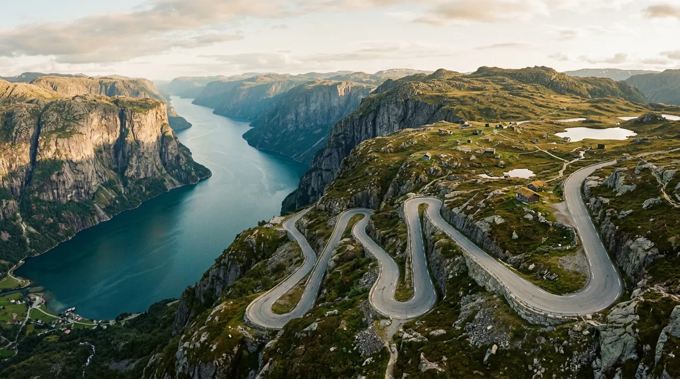
Twenty-seven hairpin bends. We counted them twice because we did not believe it the first time. Twenty-seven turns carved into the mountainside above Lysefjord, one of the deepest and most dramatic fjords in Norway, on a road that almost nobody outside Rogaland has heard of. Trollstigen gets the postcards. Trollstigen gets the tour buses. Trollstigen gets the viewing platforms with glass floors and gift shops selling troll figurines. Lysevegen gets driven by people who are going somewhere – to the Kjerag trailhead, to the Preikestolen parking lot, to the mountain farms at the top – and who happen to experience one of the finest mountain roads in northern Europe on the way.
We first drove Lysevegen by accident, which is the best way to discover anything worth discovering. We were heading to the Kjerag hike, following the GPS, not expecting much from the road itself. The GPS said “turn left” and the road went vertical. Eight kilometers later, 740 meters higher, and twenty-seven hairpins older, we parked at the top and sat in the car for five minutes, trying to process what had just happened. Then we drove back down and did it again, because the hike could wait.
Why drive Lysevegen
Lysevegen occupies a strange position in Norwegian mountain driving. It is objectively excellent – more hairpins than Trollstigen, similar gradient, comparable scenery, and open year-round instead of Trollstigen’s seasonal five-month window. But it has no marketing budget, no Norwegian Scenic Routes designation, no visitor center, no gift shop. It is a county road that happens to climb a cliff face above a fjord. This anonymity is, frankly, its greatest asset.
The road was completed in 1984, connecting the isolated farms and summer pastures above Lysefjord to the outside world. Before that, the mountain farmers above the fjord were accessible only by boat or by walking paths that were, by all accounts, terrifying. The road was built for practical reasons – agriculture, mail delivery, not dying of isolation during winter storms – and the result is practical in character. No architectural flourishes. No viewing platforms. Just a well-engineered road that goes up a mountain because someone needed it to.
What it lacks in infrastructure it compensates for in driving experience. The 27 hairpins are tighter and more rhythmic than Trollstigen’s 11. Where Trollstigen’s turns are spaced out with relatively long straight sections between them, Lysevegen’s come in rapid succession – turn, straighten, turn, straighten, turn – a driving cadence that rewards smooth inputs and punishes anyone who tries to rush. The road is narrow but well-surfaced, and the gradient is steep but consistent. It is, in the purest sense, a driver’s road.
And then there is the fjord. Lysefjord drops 604 meters from the plateau to the water surface, and on the exposed sections of Lysevegen you can see straight down to it. The water is a dark, cold blue-green – the color of depth. Cruise ships occasionally pass through, and from 700 meters above they look like white insects on dark glass.
Which direction to drive
West to east – starting from the fjord side and climbing to the plateau. The reasoning is the same as Trollstigen: you want to be climbing, building toward the big views, watching the fjord recede below you with each hairpin. The drama increases as you go up. Descending, it decreases. This is not complicated storytelling.
There is a practical argument too. The hairpin sections are narrower than the approach road, and climbing gives you better visibility of oncoming vehicles. Descending, the blind hairpins require constant vigilance and frequent use of the horn – not because the road is dangerous per se, but because meeting a campervan on a hairpin bend with a 500-meter drop to the left is the kind of surprise that improves nobody’s day.
That said, many people will drive Lysevegen east to west as part of a loop from Stavanger, in which case descending is unavoidable. If that is your route, go slowly, use second gear for engine braking, and sound your horn before every blind turn. The road is manageable in both directions. It is simply better going up.
Kilometer by kilometer
The Lysefjord approach (0-3 km)
The drive begins at the edge of Lysefjord, where the road leaves the waterside route (Rv 13) and turns inland. The junction is easy to miss if you are not looking for it – a small sign for Lysebotn and a road that immediately starts climbing through birch forest.
The first three kilometers are deceptive. The gradient is moderate, the road is two lanes, and the forest screens the fjord from view. You might think this is going to be a pleasant, undemanding mountain drive. You would be wrong, but for now, enjoy the birch trees.
The lower hairpins: 1-12 (3-5.5 km)
The road narrows to single lane without warning, and the first hairpin arrives like a punctuation mark. The forest thins, the fjord appears below, and suddenly you are driving on a shelf cut into the mountainside with nothing between you and the water except air and a low metal barrier that looks like it was designed to stop a bicycle, not a car.
Hairpins one through twelve are the most technically demanding section. The turns are tight – some requiring full lock in a standard car – and the road surface, while good, has some rough patches near the drainage channels. The passing places are adequate but not generous. If you meet another vehicle, one of you will need to reverse, and on a single-lane hairpin road with a fjord 400 meters below, “reverse” is a word that carries more weight than usual.
The views escalate rapidly. By hairpin five, you can see the full width of Lysefjord stretching toward the sea. By hairpin eight, you can see the Preikestolen plateau across the fjord – the famous Pulpit Rock, which from this angle looks like a flat-topped tooth jutting from the cliff face. By hairpin twelve, you are above the tree line and the landscape opens into bare rock, moss, and sky.
We met a Norwegian farmer in a battered Toyota Hilux between hairpins nine and ten. He reversed three hundred meters to a passing place without hesitation, waved us past, and drove on as if reversing on a cliff-edge road were the most ordinary thing in the world. It probably was, for him. He had the easy confidence of someone who has done something ten thousand times.
The middle section: 12-20 (5.5-6.8 km)
The road enters a transitional zone between fjord and plateau. The hairpins continue but are spaced further apart, with longer straight sections between them. The gradient remains steep, but the exposure decreases as the terrain becomes more rolling. Mountain streams cross the road in several places – small enough in summer, but in spring meltwater season they can be substantial.
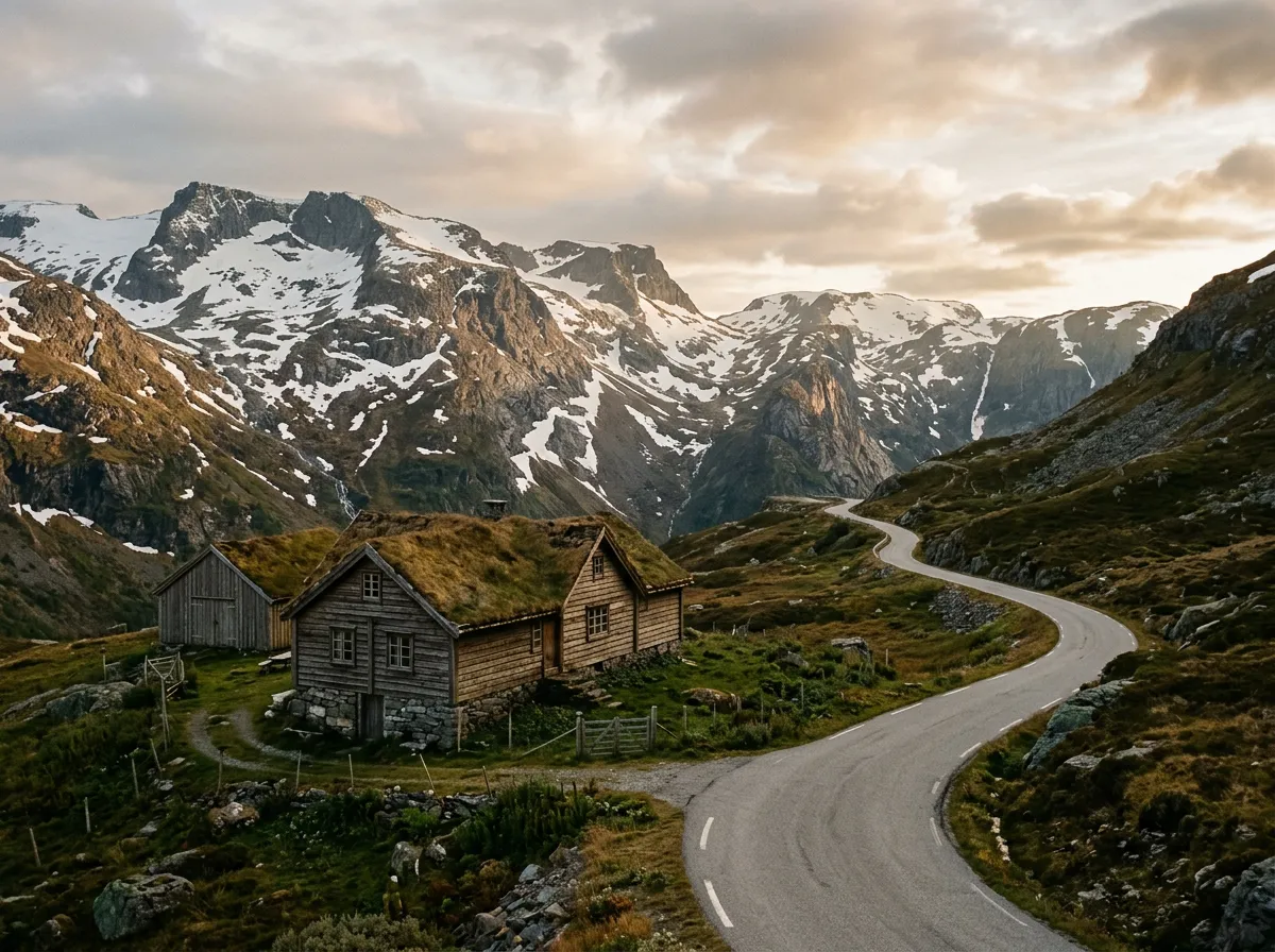
This section passes several of the old mountain farms – small stone-and-timber buildings with turf roofs that are now mostly used as summer cabins. The farms sit on small patches of flat ground that seem impossibly precarious given the terrain. How anyone farmed here, in any century, is a question that the road itself was built to answer.
The upper hairpins: 20-27 (6.8-8 km)
The final seven hairpins deliver you onto the mountain plateau. The turns are gentler here – the cliff is less steep, the drops less extreme – but the altitude is now 700+ meters and the weather can change with startling speed. We have driven the lower hairpins in sunshine and arrived at the top in horizontal rain, the transition happening over the course of three turns.
Hairpin 27 – the last – is almost celebratory in character. The road straightens, widens to two lanes, and the plateau opens ahead. The Kjerag trailhead is a few minutes further east, and the parking lot (which charges 300 NOK per day) serves as the de facto summit stop for the road.
The plateau itself is austere – bare rock, small lakes, low scrubby vegetation, and wind. Always wind. After the enclosed intensity of the hairpin road, the openness feels disorienting, like walking out of a cinema into daylight.
Practical information
| Detail | Info |
|---|---|
| Road designation | Fv 500 (county road) |
| Opening dates | Year-round (chains may be required Nov-Apr) |
| Toll | Free |
| Fuel | Last fuel in Lauvvik or Forsand (west) or Sirdal (east) |
| Parking | Kjerag trailhead: 300 NOK/day. Limited roadside pullouts on hairpins. |
| Best time | Jun-Sep for dry road; mornings before hikers fill the road |
| Avoid | Saturday mornings Jul-Aug (Kjerag hikers create traffic on hairpins) |
| Winter driving | Road stays open but may require winter tires/chains. Check conditions at vegvesen.no |
| Vehicle restrictions | No length restrictions posted, but campervans over 7m will find the hairpins uncomfortable |
The Kjerag and Preikestolen connection
Most people driving Lysevegen are heading to one of two hikes: Kjerag (the famous boulder wedged in a crack 984 meters above the fjord) or Preikestolen (the Pulpit Rock, a flat cliff face 604 meters above the water). Both are world-class hikes, and both require the drive up Lysevegen as the price of admission.
If you are combining the drive with a hike, plan accordingly. The Kjerag hike is 10-12 km round trip and takes 5-7 hours. Preikestolen is accessed from the other side of the fjord (via ferry or the long way round via Rv 13), but Lysevegen provides the most dramatic viewpoint of Preikestolen from across the fjord.
Our recommendation: drive Lysevegen for the road first. Do the hike second. Too many people treat the drive as transportation to the trailhead and miss the fact that they are driving one of the best mountain roads in Scandinavia.
Why Lysevegen deserves more attention
We have driven Trollstigen and Lysevegen in the same week, multiple times, and we keep coming back to the same conclusion: Lysevegen is the better drive. Trollstigen is the better spectacle – more dramatic setting, more imposing cliff face, that waterfall – but as a piece of road, as something to steer a car through, Lysevegen wins. More hairpins, better rhythm, less traffic, no tour buses, and the fjord views are at least equal.
Trollstigen is a five-month road. Lysevegen is open year-round. Trollstigen has a gift shop at the top. Lysevegen has a parking lot and a trailhead. One is a tourist attraction that happens to be a road. The other is a road that happens to be extraordinary.
Combine with nearby passes
Lysevegen is part of our Fjord Vertigo Loop, a four-day itinerary that also includes Trollstigen and Stalheimskleiva. If you want to experience the full range of Norwegian mountain driving – from celebrity pass to hidden gem to white-knuckle descent – that route covers it.
For more Norway mountain roads, see the Norway hub.