Furka Pass
The first time you crest the Furka, you pull over not because the view demands it — though it does — but because your hands need a moment to unclench from the steering wheel. Behind you, sixteen hairpins drop away toward Realp in a geometry that looks designed by someone who genuinely hated straight lines. Ahead, the Rhone Glacier hangs in its valley like a dirty tongue of ice that has been retreating for a century and still manages to look magnificent. And somewhere on this exact stretch of asphalt, Sean Connery’s Aston Martin DB5 was chased by Auric Goldfinger’s 1937 Rolls-Royce. We drove it on a Tuesday morning in September and had the summit to ourselves. The Bond villains, sadly, were elsewhere.
Why drive Furka Pass
The Furka is not the highest Swiss pass. It is not the longest, the steepest, or the most technically demanding. What it is, precisely, is the most cinematic. The combination of tight hairpins, a glacier backdrop, and that unmistakable Goldfinger heritage makes it the pass that non-drivers have actually heard of. This is useful when explaining to a skeptical travel companion why you have planned three days of driving in central Switzerland.
But the Furka earns its reputation honestly. The eastern ascent from Realp packs sixteen numbered hairpins into roughly six kilometers of vertical gain, each one tighter than the last. The road surface is immaculate — the Swiss maintain their passes with the same compulsive precision they apply to watchmaking. And the western descent toward Gletsch opens up into sweeping curves with views of the Rhone Valley that belong on a postcard, if postcards could capture the smell of hot brakes and alpine wildflowers.
The Furka also sits at the center of Swiss pass country. You can chain it with Grimsel (they share a junction at Gletsch), then add Susten and Gotthard for the full Alpine Pass Pentathlon. But on its own, the Furka is a complete experience: challenging enough to hold your attention, short enough to drive twice in one morning.
Which direction to drive
East to west. Always east to west.
We have strong opinions about pass directions, and on the Furka, the argument is straightforward. Starting from Realp (east side), you get the hairpins on the ascent, where your engine is working hard but your brakes are not. The sixteen switchbacks climb the Furkahorn’s flank in a series of progressively tighter turns that reward a driver who can place the car precisely at the apex.
Driving west to east means descending those same hairpins, which is harder on your brakes, harder on your nerves, and harder on your passengers. We have seen rental cars with brake fade smoke drifting from their front wheels on the eastern descent. That is not where you want to discover that the Renault Clio you rented in Zurich has the stopping power of a shopping trolley.
The western descent from the summit toward Gletsch is gentler, with longer radius curves and better sightlines. You can actually enjoy the glacier views instead of staring at your brake temperature gauge. And the final drop into the Rhone Valley at Gletsch feels like a reward — the road opens up, the valley spreads below you, and you arrive at the Grimsel/Furka junction with enough confidence to consider doing the whole thing again.
The Goldfinger connection
In 1964, the Furka Pass played itself in the James Bond film Goldfinger. The chase sequence — Connery’s silver DB5 pursued by Goldfinger’s Rolls-Royce and Tilly Masterson’s white Ford Mustang — was filmed on the upper hairpins of the eastern ascent. The specific stretch is between hairpins 11 and 14, and yes, we stopped to verify.
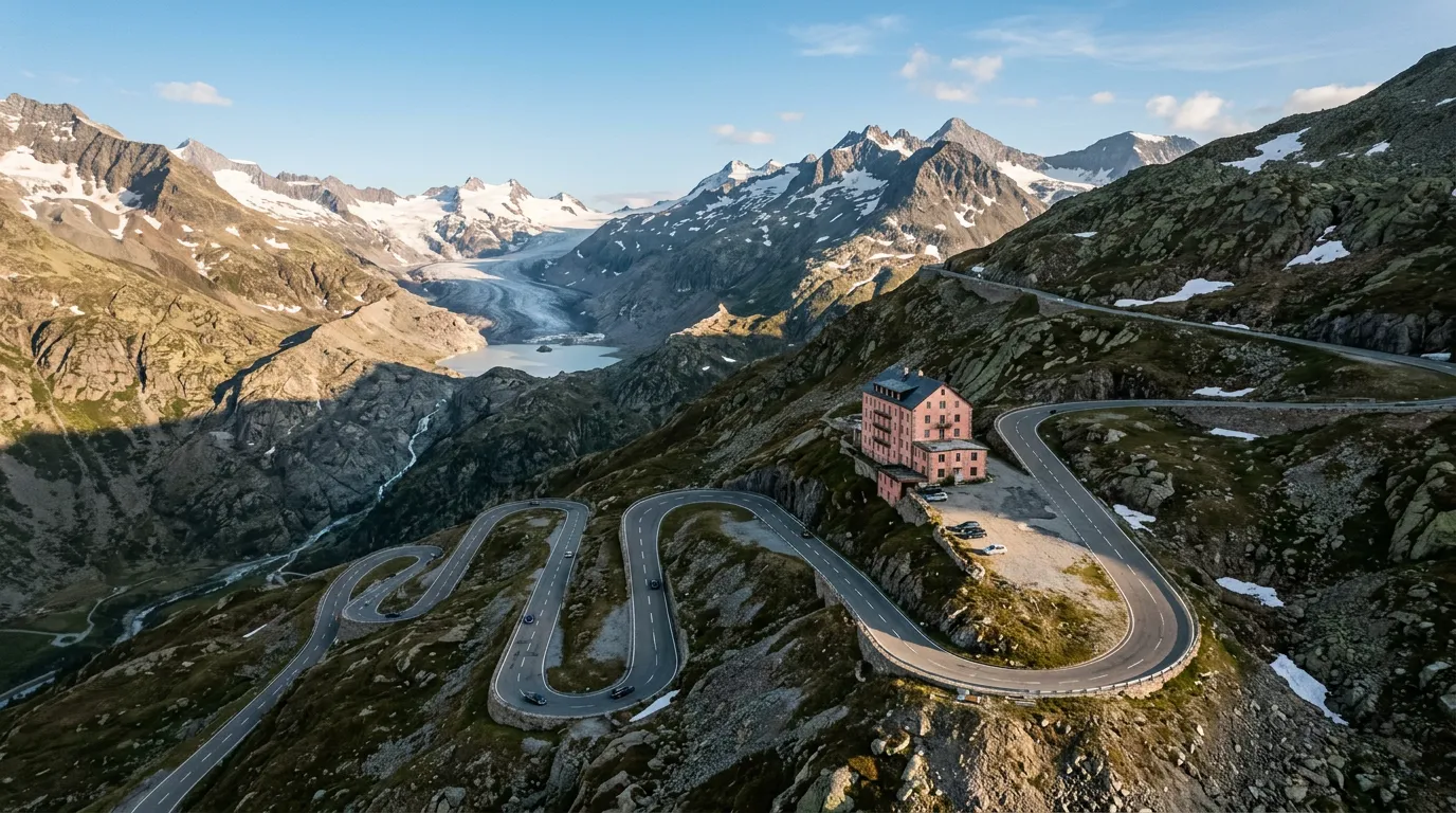
The Hotel Belvedere, that distinctive pink building perched above the Rhone Glacier, appears in several shots. It closed permanently in 2015, and the building now sits empty above the road like a monument to both the glacier’s retreat and the economics of alpine hospitality. You can still pull over in the adjacent car park to photograph the glacier — or what remains of it — from the same angle the film crew used sixty years ago.
A small plaque near the hotel marks the filming location. We spent an unreasonable amount of time standing in the exact spot where Connery’s stunt double executed that particular turn. The hairpin has not changed. The glacier, unfortunately, has.
Kilometer by kilometer
Km 0-3: Realp to the tree line
The journey starts in Realp, a quiet village at 1,538m that exists primarily as a staging point for the Furka and as the eastern portal of the Furka Base Tunnel (the train tunnel, not a road — a distinction that matters when your GPS gets confused). Leave the village heading west and the road immediately begins to climb through sparse conifer forest. The first three hairpins arrive quickly, spaced generously apart, with good visibility through each turn. Consider these your warm-up.
The gradient averages 8% through this section. In a modern car with reasonable power, you will not notice. In the 85-horsepower Fiat Punto we once rented in Lugano, we noticed.
Km 3-6: The hairpin staircase
Above the tree line, the road gets serious. Hairpins 4 through 10 march up the mountainside in tight switchbacks, each one folding back on the one below it. From above, this section looks like a child drew a zigzag on the mountain with a crayon. From inside the car, it looks like the road ahead is approximately three meters long before it turns 180 degrees.
The asphalt quality here is excellent, with good grip even in damp conditions. Each hairpin has a numbered post — a Swiss touch that we find both helpful and slightly obsessive, which is to say, we appreciate it deeply. The outside edges have solid guardrails. The inside edges have granite walls that will remove your wing mirror if you cut the apex too aggressively.
Traffic is the main variable. On summer weekends, you may meet tour buses, cyclists, and motorcyclists — occasionally all three in the same hairpin. Motorcyclists on the Furka tend to be competent (this is not a beginner road), but they also tend to be fast. Let them pass.
Km 6-8: Hotel Belvedere and the Rhone Glacier
Hairpins 11 through 14 occupy the most photogenic section of the pass. This is the Goldfinger stretch, and on clear days, every second car pulls over to take the same photograph. The road carves along the flank of the mountain with the Rhone Glacier visible below and to the south.
The Hotel Belvedere sits at roughly the 2,200m mark. The parking area here is the obvious stop for glacier viewing, photographs, and allowing your brakes to cool. We recommend stopping even if you have no interest in James Bond or glaciology, because the next two kilometers to the summit are the most exposed section of the pass, and starting them with cold brakes and a calm heart rate is advisable.
The Rhone Glacier ice grotto — a tunnel carved into the glacier that was a major tourist attraction for over a century — closed when the glacier retreated too far from the road. The glacier itself is now wrapped in reflective blankets during summer to slow the melting, which gives it a distinctly post-apocalyptic appearance that somehow enhances rather than diminishes the experience.
Km 8-10: The summit approach
Hairpins 15 and 16 deliver you to the summit at 2,429m. The road here is exposed to wind, and in early or late season, ice patches are a genuine possibility. The summit itself is marked by a modest pass sign and a small parking area. There is no grand building or visitor center — just the sign, the view, and whatever weather the Alps have decided to throw at you.
On a clear day, the panorama from the summit includes the Bernese Oberland peaks to the north and the Valais mountains to the south. On an unclear day, you will see approximately fifteen meters of wet asphalt and the rear bumper of the car in front of you. We have experienced both. The clear day is better.
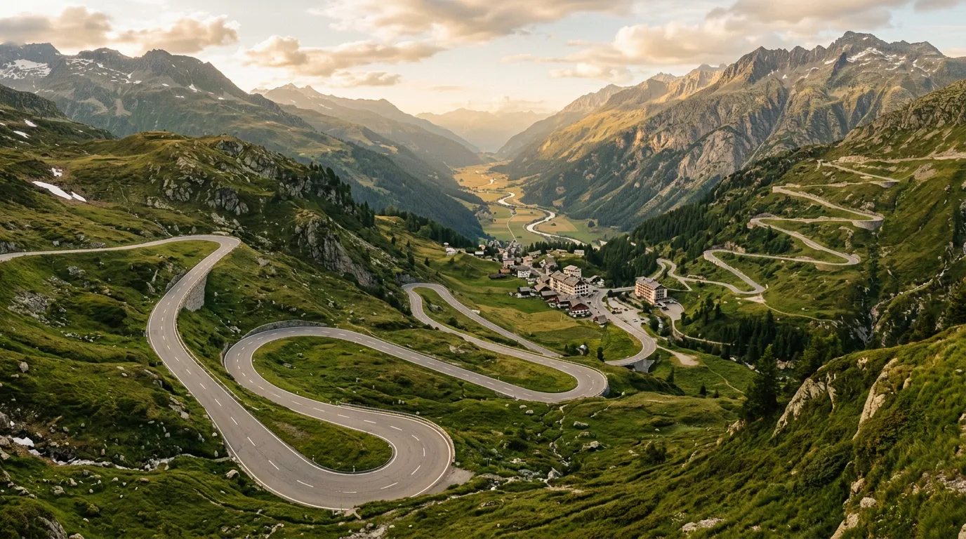
Km 10-12: The western descent to Gletsch
The western side of the Furka is a different character entirely. Where the east is a relentless staircase of hairpins, the west unfolds in longer, sweeping curves that allow you to actually use third gear. The descent to Gletsch covers about 700m of elevation loss over four kilometers, with a gradient that rarely exceeds 9%.
The views on this side are expansive. The Rhone Valley opens below you, and on the approach to Gletsch, you can see the Grimsel Pass road climbing the opposite valley wall — which is useful for planning, because if you have just driven the Furka and are considering the Grimsel immediately afterward, you can assess the traffic and weather on the Grimsel from here.
Gletsch itself is a hamlet at the junction of the Furka and Grimsel roads. There is a historic hotel (the Hotel Glacier du Rhone, operational since the 1830s), a fuel station, and the Furka steam railway terminus. This is the logical place to decide: Grimsel next, or turn around and drive the Furka again?
Practical information
| Detail | Information |
|---|---|
| Opening dates | Typically mid-June to mid-October (exact dates vary yearly, check TCS) |
| Toll | None — the Furka is a free public road |
| Fuel | Last fuel before east ascent: Realp or Andermatt. Last fuel before west: Oberwald. None at summit. |
| Parking | Free parking at Hotel Belvedere viewpoint (east side) and at the summit. Small lot at Gletsch. |
| Best time of day | Early morning (before 9 AM) or late afternoon (after 4 PM) for minimal traffic |
| Avoid | Weekend afternoons Jul-Aug. Tour bus convoys. The first week after opening (ice/gravel debris). |
| Length | 12 km ascent from Realp to summit; 4 km descent to Gletsch |
| Drive time | 30-45 minutes Realp to Gletsch, depending on traffic and photography stops |
| Alternative | Furka Base Tunnel (car train, Realp-Oberwald, operates year-round) |
Combine with nearby passes
The Furka sits at the crossroads of Swiss pass country. The obvious combinations:
Furka + Grimsel: Share a junction at Gletsch. Drive the Furka east-to-west, refuel at Gletsch, then climb the Grimsel northward toward Innertkirchen. Total: about 38km and 2-3 hours.
Furka + Susten: Drive the Furka, then the Grimsel, then continue to the Susten — three passes in one day. This is the core of the Alpine Pass Pentathlon, and it is entirely feasible in good weather.
Furka + Gotthard: From Realp (east side of the Furka), it is a short drive south to Andermatt and the start of the Gotthard Pass. The old Tremola cobblestone road is a completely different driving experience from the Furka’s smooth asphalt, and the combination gives you both modern engineering and medieval ambition in a single day.
For the full multi-day experience, see our Alpine Pass Pentathlon — five passes in three days, with Andermatt as your base.
We have driven the Furka in rain, fog, sunshine, and once in a brief hailstorm that appeared from nowhere and vanished just as quickly. Every condition has its character. But if you get one clear morning on this pass, with the glacier catching the early light and no one else on the road, you will understand why this particular twelve kilometers of Swiss asphalt has been famous for sixty years.