Gotthard Pass
The modern world drives under the Gotthard. The 17-kilometer motorway tunnel, opened in 1980, swallows 17,000 vehicles daily and delivers them to the other side of the Alps in twelve air-conditioned minutes. The even newer Gotthard Base Tunnel — at 57 kilometers, the longest rail tunnel on Earth — does the same for trains. Both tunnels are triumphs of Swiss engineering, and both are completely irrelevant to anyone who cares about driving, because above them, on top of the mountain, the old road is still there. It has been there for eight hundred years. Its cobblestones are still cobblestones. Its thirty-seven hairpins still hairpin. And on a September morning, with the tunnels humming with traffic far below, we had the Tremola road entirely to ourselves.
Why drive Gotthard Pass
The Gotthard is not Switzerland’s highest pass, its most scenic, or its most technically demanding. It is its most important. For centuries, this was the primary route between northern and southern Europe — the crossing that connected the German-speaking cantons to Italian-speaking Ticino and, beyond it, to Lombardy and the Mediterranean. Emperors crossed here. Armies crossed here. Trade caravans loaded with silk and spices crossed here. The history of European transportation literally runs through this notch in the Alps.
But we are not here for the history lecture. We are here because the old Tremola road — the southern approach built between 1827 and 1832 — is one of the most extraordinary driving experiences in Switzerland. Twenty-four hairpins descend the southern face on original granite cobblestones, each switchback folding over the one below it in a pattern so dense that from above, the road looks like a piece of intestine laid on the mountainside. The cobblestones rattle your steering wheel. The stone walls on either side predate every car that has ever driven between them. And the sheer improbability of this road — that it exists, that it was built by hand, that it still functions — makes every other pass feel slightly modern and slightly insufficient.
The northern approach on the modern road (built 1965) is smooth asphalt with thirteen hairpins and perfectly competent engineering. It is the warm-up. The Tremola is the event.
Which direction to drive
North to south. Start in Andermatt (1,437m) and finish in Airolo (1,175m).
This direction gives you the modern asphalt road on the ascent and the Tremola cobblestones on the descent. The reasoning is practical: climbing cobblestones is hard on a car (and your fillings); descending them is merely loud. In first or second gear, at 20-30 km/h, the Tremola is a manageable rattle. Climbing it requires more power, more wheelspin on the polished stones, and more patience.
There is also a psychological argument. Building from the efficient modern road to the historic cobblestone road creates a sense of traveling backward in time. You start in the 21st century and end in the 19th. The summit — with its hospice, its museum, and its bleak moorland — is the threshold between eras.
Driving south to north puts the Tremola on your ascent and the modern road on your descent, which is the less dramatic ordering. It also means your last impression of the Gotthard is smooth asphalt, which is like ending a symphony with a ringtone.
Kilometer by kilometer
Km 0-5: Andermatt to Hospental
The road begins in Andermatt, a town that has been a crossroads since the Romans. Andermatt sits at the junction of three pass roads — the Gotthard (south), the Furka (west), and the Oberalp (east) — and it has the infrastructure of a place that understands mountain driving: rental agencies, fuel stations, hotels with heated garages, and restaurants accustomed to diners whose hands are still slightly shaking.
The first three kilometers to Hospental are flat valley road, following the Reuss River. Hospental is a village with a medieval tower and a fork in the road: left for the Gotthard, right for the Furka. Take the left.
Km 5-10: The northern ascent
Above Hospental, the modern road begins to climb through alpine meadow. The thirteen hairpins of the northern approach are wide, well-surfaced, and consistently graded at 7-8%. This is modern Swiss road engineering at its best — each curve precisely calculated, each gradient uniform, each guardrail exactly where it should be.
The landscape is open grassland dotted with granite boulders, gradually giving way to bare rock as you climb above 2,000 meters. The hairpins offer views back down to Hospental and the Urseren Valley, with the Furka road visible climbing the western wall of the valley if the light is right.
This section is where you will encounter most of the traffic. Motorcyclists use the Gotthard heavily — it is a popular run from Andermatt — and tour buses still cross the old road during peak season. The road is wide enough that passing is straightforward, but be aware of bus overtaking distances on the hairpins.
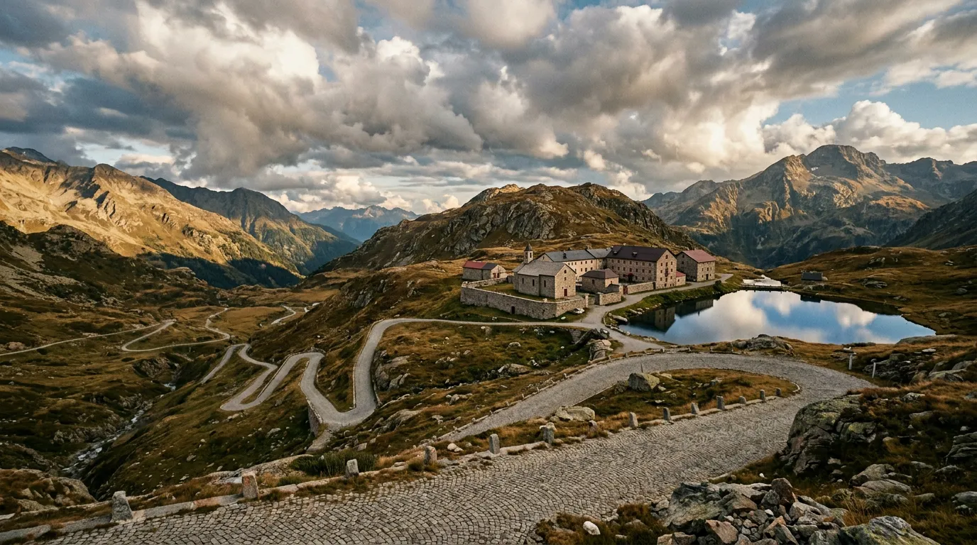
Km 10-13: The summit
The Gotthard summit at 2,106m is a place of historical density. The San Gottardo Hospice — originally founded in the 14th century, rebuilt multiple times — now houses a hotel and the Gotthard National Museum. The museum covers the pass’s role in Swiss history, from the medieval mule trains to the tunnels, and is worth an hour if you have the time.
Beside the hospice, the Lago della Piazza (a small artificial lake) and the surrounding moorland have the austere, windswept quality of high alpine terrain. The summit feels exposed — there are no sheltering valleys or protective peaks, just the mountain notch and the wind.
The pass marker and border sign (Canton Uri to Canton Ticino) make for the obligatory photograph. On clear days, you can see south to the beginning of the Tremola and understand, with a mixture of anticipation and mild concern, exactly how far that road drops.
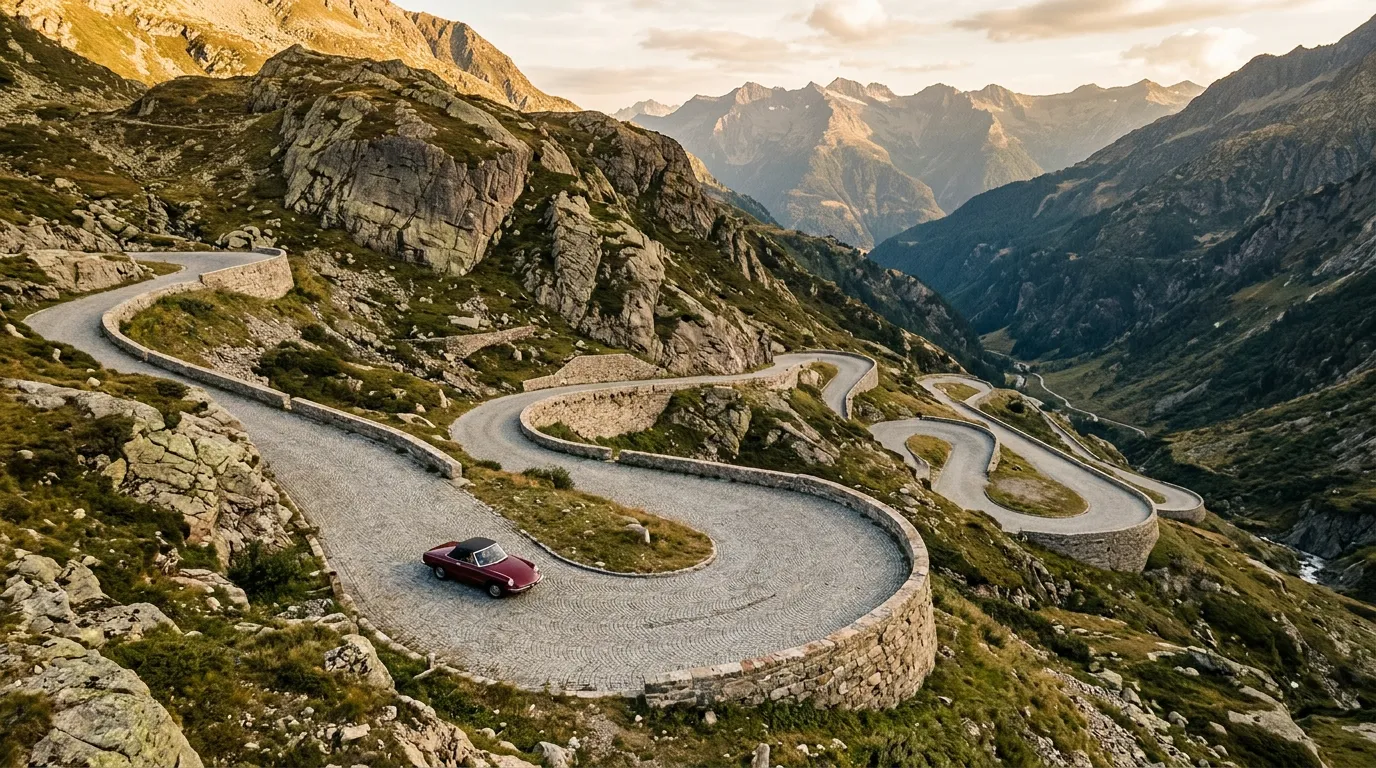
Km 13-20: The Tremola
Here is where the Gotthard becomes the Gotthard.
At the summit’s southern edge, the road forks. To the right, a modern two-lane road descends to Airolo in smooth asphalt curves — the sensible option, the one the buses take, the one your GPS will recommend. To the left, a narrower road drops away on granite cobblestones with a sign that reads “Tremola” and a gradient warning that should be taken at face value.
The Tremola is 7 kilometers of continuous cobblestone road with 24 hairpins. The stones are original 19th-century granite setts, worn smooth by two centuries of traffic. They are beautiful, historic, and spectacularly uncomfortable to drive on at anything above 25 km/h. Your steering wheel will vibrate. Your teeth will rattle. Your passengers will ask if something is wrong with the car.
Nothing is wrong with the car. Everything is exactly as it has been since 1832.
The hairpins are tight and stacked. From certain viewpoints on the upper section, you can count twelve switchbacks below you, each one a thin line of cobblestone folding back on the one above it. The stone walls on either side are low — low enough that you can see over them, which on the exposed outer edges reveals a drop that concentrates the attention.
The road width varies. On the straighter sections between hairpins, two cars can pass with care. On the hairpins themselves, it is effectively single-track. Meeting an oncoming vehicle on a Tremola hairpin requires one of you to reverse, and reversing on cobblestones on a 10% grade is an experience that builds character.
Traffic is usually light — most drivers take the modern road, and the Tremola’s condition deters casual traffic. On our last visit, we encountered three cars and one cyclist in the entire descent. The cyclist looked determined and slightly insane, which is the correct attitude for cycling up the Tremola.
Km 20-26: Airolo
The Tremola delivers you to Airolo (1,175m), the first Ticino town south of the Alps. The transition is jarring: from 19th-century cobblestones to Italian-speaking Switzerland, with its warmer air, its palm trees (at lower elevations), and its espresso. Airolo has fuel, hotels, and the southern portal of the Gotthard motorway tunnel. You have crossed the Alps the hard way while 17,000 cars per day do it the easy way beneath your feet.
Practical information
| Detail | Information |
|---|---|
| Opening dates | Typically early June to mid-October |
| Toll | None |
| Fuel | Andermatt (north), Airolo (south). None on the pass or the Tremola. |
| Parking | Free at the summit (Hospice area). Limited pull-offs on the Tremola. |
| Best time of day | Morning for the Tremola — sun hits the southern face early and the light on the cobblestones is beautiful |
| Avoid | Wet cobblestones on the Tremola (grip is significantly reduced). Bus convoys on the northern approach in peak season. |
| Length | 26 km Andermatt to Airolo (via Tremola); 20 km via modern road |
| Drive time | 60-90 minutes via Tremola; 30-40 minutes via modern road |
| Facilities | Hotel, museum, and restaurant at the summit Hospice. Full services in Andermatt and Airolo. |
| Special note | The Tremola cobblestones are a national heritage road. Drive gently. |
The Tremola vs. the modern road
Be clear about the choice: the modern south road and the Tremola run parallel. You can see both from the summit. The modern road is faster, smoother, and safer. The Tremola is slower, rougher, and historically important. There is no wrong choice, but there is only one memorable one.
If you are uncomfortable with cobblestones, narrow roads, or steep gradients, take the modern road south and enjoy it — it is a perfectly good alpine descent. But if you have come to the Gotthard for the Gotthard, the Tremola is non-negotiable. Every other pass in Switzerland has asphalt. Only one has the cobblestones that Goethe described, Napoleon improved, and two centuries of traffic has polished to a shine.
Combine with nearby passes
Gotthard + Furka: From Andermatt, the Furka heads west through the same valley. Drive the Gotthard in the morning (north to south, finishing in Airolo), return through the motorway tunnel to Andermatt (15 minutes), then drive the Furka in the afternoon. Two passes, two entirely different centuries of road building.
Gotthard + Nufenen: From Airolo (south end of Gotthard), the Nufenen Pass heads west toward the Valais. At 2,478m, the Nufenen is Switzerland’s highest paved pass, and it pairs well with the Gotthard for a south-of-the-Alps loop.
The Pentathlon: The Gotthard is day three of the Alpine Pass Pentathlon, combined with the Nufenen for a final day that covers the most historical and the highest passes in the route.
We have a theory about the Gotthard. Every driver who crosses it by tunnel or train feels, somewhere in the back of their mind, that they have cheated. The Alps are supposed to be crossed, not bypassed. The Tremola road is the antidote to that feeling — it is the crossing as it was meant to be, stone by stone, hairpin by hairpin, with the full weight of eight hundred years of alpine transit pressing on your steering wheel. It takes ninety minutes instead of twelve. It is worth every single one of them.