Susten Pass
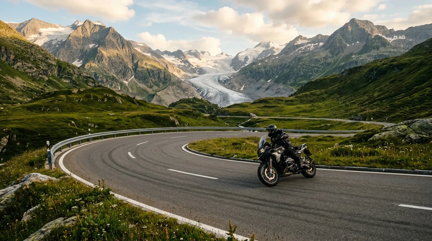
There is a photograph that every driver takes on the Susten Pass. It is from the eastern approach, somewhere around the 1,800-meter mark, looking back down the valley at the road you have just climbed. The asphalt sweeps through a long, banking curve with a grace that looks engineered for a car commercial rather than practical transportation. Behind the curve, the Stein Glacier hangs between two ridges like a frozen waterfall. Below, the valley drops away into haze. We have taken this photograph four times now, in four different rental cars, and it never gets less remarkable. The Susten is the Swiss pass that was built to be beautiful, and it knows it.
Why drive Susten Pass
Every Swiss pass has a character. The Furka is cinematic. The Grimsel is eerie. The Gotthard is historical. The Susten is elegant. This is the pass where the road itself is the attraction — not the glacier, not the summit, not the hairpins, but the way the asphalt curves through the landscape with a fluency that makes every other mountain road feel like it was drawn by a less talented engineer.
The Sustenstrasse was completed in 1946, making it one of the newer Swiss alpine roads. Its designers had the advantage of modern road-building techniques and, it appears, a genuine aesthetic sensibility. The curves are long and flowing. The hairpins, where they exist, are generously radiused. The road width is consistent and comfortable. Driving the Susten feels like the mountain invited the road in, rather than the road forcing its way through.
None of this means the Susten is easy. Twenty-two hairpins over 28 kilometers, with gradients up to 9%, will keep you occupied. The western descent in particular demands attention — the drop from the summit tunnel to Wassen in the Reuss Valley is steep and sustained. But the difficulty here is more about concentration than white-knuckle fear. The Susten asks you to drive well, not to drive scared.
The Steingletscher (Stein Glacier) provides the dramatic scenery. Visible from the eastern approach, the glacier terminates in a small lake that has grown substantially as the ice retreats. The glacier access road (a dead end, worth the detour) gets you close enough to hear the meltwater, and the main road offers multiple pull-offs with glacier views. Combined with the pass road itself, this makes the Susten arguably the most photogenic drive in Switzerland — a country that does not lack for competition.
Which direction to drive
East to west. Start in Wassen or Innertkirchen (east side) and finish in Innertkirchen or continue west.
Actually, wait. This requires clarification. The Susten connects Wassen (in the Reuss Valley, east end) to Innertkirchen (in the Haslital, west end). When we say east to west, we mean starting from the Wassen side.
The reason is the Steingletscher. Driving east to west, the glacier unfolds ahead of you as you climb — it appears in your windshield, grows larger with each curve, and dominates the landscape for the final five kilometers before the summit tunnel. Driving west to east, the glacier is behind you. You see it in your mirrors, which is not the same thing at all.
The eastern ascent also offers the best curves on the climb, where you can appreciate them at moderate speed. The western descent is steeper and faster, which means more braking and less time to admire the road’s geometry. Better to climb the beautiful side and descend the steep side than the reverse.
If you are chaining the Susten with the Grimsel (coming from Innertkirchen), you will approach from the west. This is fine — the Susten is good in both directions. But given a choice, choose east to west.
Kilometer by kilometer
Km 0-6: Wassen to the Meien Valley
From Wassen (altitude 930m), the Sustenstrasse climbs through the side valley of the Meienreuss. This is the gentle introduction — the road follows the river through mixed forest, gaining altitude gradually with no hairpins to speak of. The village of Meien (1,320m) is the last settlement of any size before the alpine zone.
This section is also where you share the road with local traffic heading to farms and villages in the valley. Drive courteously. These people live here year-round while we visit for four months. They have earned the right of way.
Km 6-12: The eastern hairpins
Above Meien, the road begins to climb in earnest. The first significant hairpins appear, winding up the valley wall through thinning forest and then above the tree line into alpine meadow. The gradient increases to 7-8%, and the hairpins tighten progressively.
This is where the Susten’s engineering shines. Each hairpin is banked thoughtfully, with enough width to take a proper racing line (not that we advocate this on a public road — we merely observe that it is possible). The asphalt is smooth and grippy, the sight lines through the turns are generous, and the guardrails on the outside edges are reassuringly substantial.
Motorcyclists love this section. On summer weekends, you will see sport bikes and touring motorcycles flowing through the hairpins in groups of three to ten. They are generally skilled and respectful — the Susten attracts experienced riders who appreciate the road quality. Let them pass when they want to pass, and enjoy watching their lines through the curves.
Km 12-18: Steingletscher approach
Above approximately 1,800 meters, the landscape opens up and the Steingletscher appears. The glacier sits in a cirque between the Tierbergli and Gwachtenhorn peaks, its ice blue-white against the gray rock. A small lake at the glacier’s terminus reflects the ice when the air is still.
The road through this section is the highlight of the Susten experience. Long, sweeping curves follow the contour of the mountain, climbing gently through terrain that has the austere beauty of high alpine landscape. Pull-offs are frequent and well-maintained — the Swiss authorities clearly understand that people are going to stop here whether there is a parking spot or not, so they have provided proper ones.
The Steingletscher Hotel, at roughly 1,860m, offers the best glacier viewing from a seated position with coffee. The dead-end road to the glacier lake branches off here. It is 2 km and worth the detour, especially in early morning when the glacier catches the first light.
Km 18-22: The summit tunnel
The final approach to the summit takes you through a landscape of bare rock and late-season snow patches. The road climbs through the last four hairpins — tighter than those below, with steeper gradient — before entering the Susten summit tunnel at 2,224m.
The tunnel is short (300m) and well-lit. It marks the border between Canton Uri (east) and Canton Bern (west). There is a parking area at the western tunnel portal with views south toward the Bernese Alps. This is the technical summit of the pass, though the tunnel means you never actually see the very highest point — you drive through it inside the mountain.
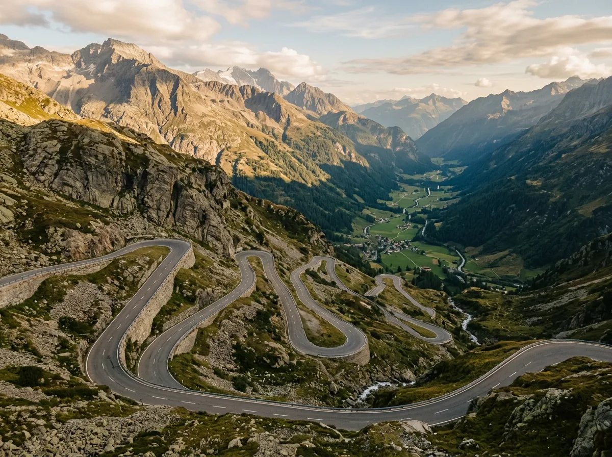
Km 22-28: Western descent to Innertkirchen
The western descent is where the Susten shows its teeth. The road drops 1,600 meters over six kilometers — a sustained, steep descent through a series of tight hairpins that are noticeably more aggressive than the eastern side. Brake management becomes important here. In a manual car, use engine braking aggressively. In an automatic, select a lower gear and resist the temptation to ride the brakes.
The views compensate for the work. The Gadmental (Gadmen Valley) opens below you, with the town of Gadmen visible far below as a cluster of rooftops in the forest. The road passes through several short tunnels and gallery sections blasted from the cliff face, with sudden views appearing through the rock openings.
Below Gadmen, the road follows the Gadmenwasser stream through forest toward Innertkirchen. This is the cool-down — easy driving through pleasant scenery, with your brakes gradually returning to a normal temperature. Innertkirchen (625m) sits at the junction with the Grimsel road, making it the natural transition point if you are chaining passes.
Practical information
| Detail | Information |
|---|---|
| Opening dates | Typically mid-June to mid-October |
| Toll | None |
| Fuel | Last fuel east: Wassen. Last fuel west: Innertkirchen. None on the pass. |
| Parking | Free at Steingletscher Hotel, summit tunnel (west portal), and multiple pull-offs |
| Best time of day | Morning for best glacier light (eastern approach). Avoid midday in summer for traffic. |
| Avoid | Weekend afternoons Jul-Aug. Large motorcyclist groups sometimes travel in convoys. |
| Length | 28 km Wassen to Innertkirchen |
| Drive time | 50-75 minutes without stops; add 30+ minutes for glacier detour |
| Facilities | Hotel and restaurant at Steingletscher. Nothing else on the pass. |
Combine with nearby passes
Susten + Grimsel: The natural pairing. From Innertkirchen, the Grimsel begins immediately. Drive the Susten east-to-west, then the Grimsel south-to-north (or continue south to Gletsch for the Furka). Two fundamentally different landscapes in one drive.
Susten + Furka + Grimsel: The triple play. Start with the Furka east-to-west from Andermatt/Realp, climb the Grimsel northward, then drive the Susten west-to-east back toward the Reuss Valley. A full day, about 70km of pass road, and three distinct characters: cinematic, lunar, elegant.
The Pentathlon: The Susten is day two of our Alpine Pass Pentathlon. After the Furka and Grimsel on day one, the Susten gets a full morning before the route continues to the Gotthard and Nufenen.
Every Swiss pass is someone’s favorite. The Furka has its film fans, the Gotthard its history buffs, the Grimsel its geology nerds. The Susten is the favorite of people who care about roads. Not mountain scenery with a road through it — but the road itself, the way asphalt meets landscape when both are at their best. We have driven more famous passes and more difficult ones, but we have never driven one that felt more deliberately, carefully beautiful.