Grimsel Pass
You come over the top of the Grimsel expecting another pretty Swiss valley and instead get the moon. Not metaphorically — the landscape above 2,000 meters on the Grimsel is genuinely lunar: polished granite slabs, dark reservoir lakes that reflect nothing because the sky has gone a peculiar shade of gunmetal, and a complete absence of anything growing. We pulled over at Totensee (yes, “Lake of the Dead” — the Swiss are more dramatic than they get credit for) and spent ten minutes wondering if we had accidentally driven to Iceland. Then a PostBus appeared around a corner, bright yellow against the gray stone, and we remembered where we were.
Why drive Grimsel Pass
The Grimsel is the Furka’s quieter, weirder neighbor. Where the Furka draws crowds with its Hollywood heritage and glacier drama, the Grimsel offers something subtler and, we would argue, more genuinely strange. This is a pass defined by water and rock: massive hydroelectric dams, turquoise reservoir lakes, and granite that has been smoothed by glaciers into shapes that look deliberately sculpted.
The driving itself is more forgiving than the Furka. The twelve hairpins are generously spaced, the gradients manageable, and the road width consistent enough that meeting a bus is inconvenient rather than terrifying. The Grimsel’s difficulty rating of 2 (Weekend driver) is accurate — this is a pass that rewards appreciation over adrenaline. You come here for the landscapes, not the switchback count.
But do not mistake “easier” for “boring.” The southern approach from Gletsch climbs through a granite canyon that narrows until the road feels carved from the rock itself — because it was. The northern descent past the Räterichsbodensee reservoir drops through a series of tunnels and gallery sections blasted from the cliff face, with views of the Aar Valley that appear and disappear through the rock windows. It is engineering on a scale that makes the road itself seem like an afterthought to the dams.
The Grimsel also chains perfectly with its neighbors. Drive the Furka east-to-west, drop into Gletsch, and climb the Grimsel northward — two passes in a morning. Continue over the Grimsel and you are fifteen minutes from the base of the Susten. This is the backbone of the Alpine Pass Pentathlon, and the Grimsel is the transition piece that holds the route together.
Which direction to drive
South to north. Start at Gletsch (1,759m) and finish in Innertkirchen (625m).
The practical reason is route logic: if you are chaining passes, you will arrive at Gletsch from the Furka and want to continue northward toward the Susten. But there is also an aesthetic argument. The southern ascent builds gradually through the granite canyon, revealing the reservoir lakes one by one as you gain altitude. The Totensee at the summit is the climax — that lunar lake surrounded by bare rock — and the northern descent gives you the reward of the Haslital Valley panorama as you drop toward the Bernese Oberland.
Driving north to south is fine, technically. But you lose the narrative arc. You start with the grand valley view, climb into the weirdness, and finish in tiny Gletsch, which — no disrespect to Gletsch — is not the triumphant conclusion that Innertkirchen provides. South to north lets the landscape tell a story: forest to granite to moonscape to reservoir to valley. North to south tells the same story backwards, and backwards stories are confusing.
Kilometer by kilometer
Km 0-5: Gletsch to the granite canyon
Leaving Gletsch, you can see the Grimsel road climbing the eastern valley wall in a series of broad curves. The first five kilometers gain about 300 meters of elevation through terrain that transitions quickly from scrubby alpine meadow to bare rock. The Rhone River — here barely more than a stream, near its source — runs below in the valley floor.
The road quality is excellent from the start. Wide asphalt, clear markings, and enough room to overtake slower traffic on the straighter sections. The first four hairpins are well-spaced and gentle, more like curves with attitude than true switchbacks.
This section is where you establish your rhythm. The Grimsel rewards smooth, consistent driving rather than the staccato hairpin-brake-accelerate of the Furka. Let the car settle into third gear and keep it there.
Km 5-10: The dam wall and Grimselsee
The road passes the Spitallamm Dam, one of the major structures of the Grimsel hydroelectric complex. The dam wall is visible from the road — a massive concrete arc holding back the Grimselsee, a reservoir whose color varies from deep blue to turquoise depending on the glacial flour content and the time of day. On gray days, the water looks like mercury.
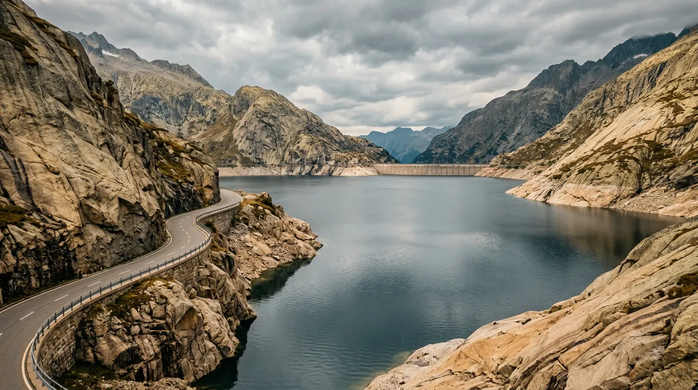
The Grimsel Hospiz — a historic hospice building that has been operating in some form since the 13th century — sits above the lake. The current building houses a hotel and restaurant, and it is the only facility of any significance on the pass. If you need coffee, fuel (you do not — there is no fuel here), or a bathroom, this is your stop.
The road along the Grimselsee is carved into the granite shore, with short tunnels and gallery sections that frame views of the lake. This stretch is slow driving by necessity — the road is narrow through the galleries, and the views are too good to rush.
Km 10-15: Ascent to Totensee
Above the Grimselsee, the landscape sheds its last pretense of hospitality. The granite becomes dominant — smooth, glacier-polished slabs stretching away from the road on both sides. Vegetation is limited to the occasional stubborn lichen. The road climbs through the remaining hairpins (8 through 12) with increasing gradient, topping out at about 10% in the final push to the summit.
The Totensee appears at roughly 2,150m, just below the summit. This small, dark lake sits in a depression between granite ridges and has a reputation for being the most atmospheric body of water in the Swiss Alps. The name — Lake of the Dead — refers to a battle fought here in 1799 between French and Austrian forces during the Napoleonic Wars. Soldiers from both sides drowned in the lake, and on overcast days, you can believe every word of the legend.
The summit at 2,164m is marked by the usual Swiss pass sign. Parking is available at the Totensee, and this is the stop you should make. Sit on the granite for ten minutes. Listen to the wind. Look at the lake. Notice how thoroughly weird this place is compared to every other Swiss mountain landscape you have seen.
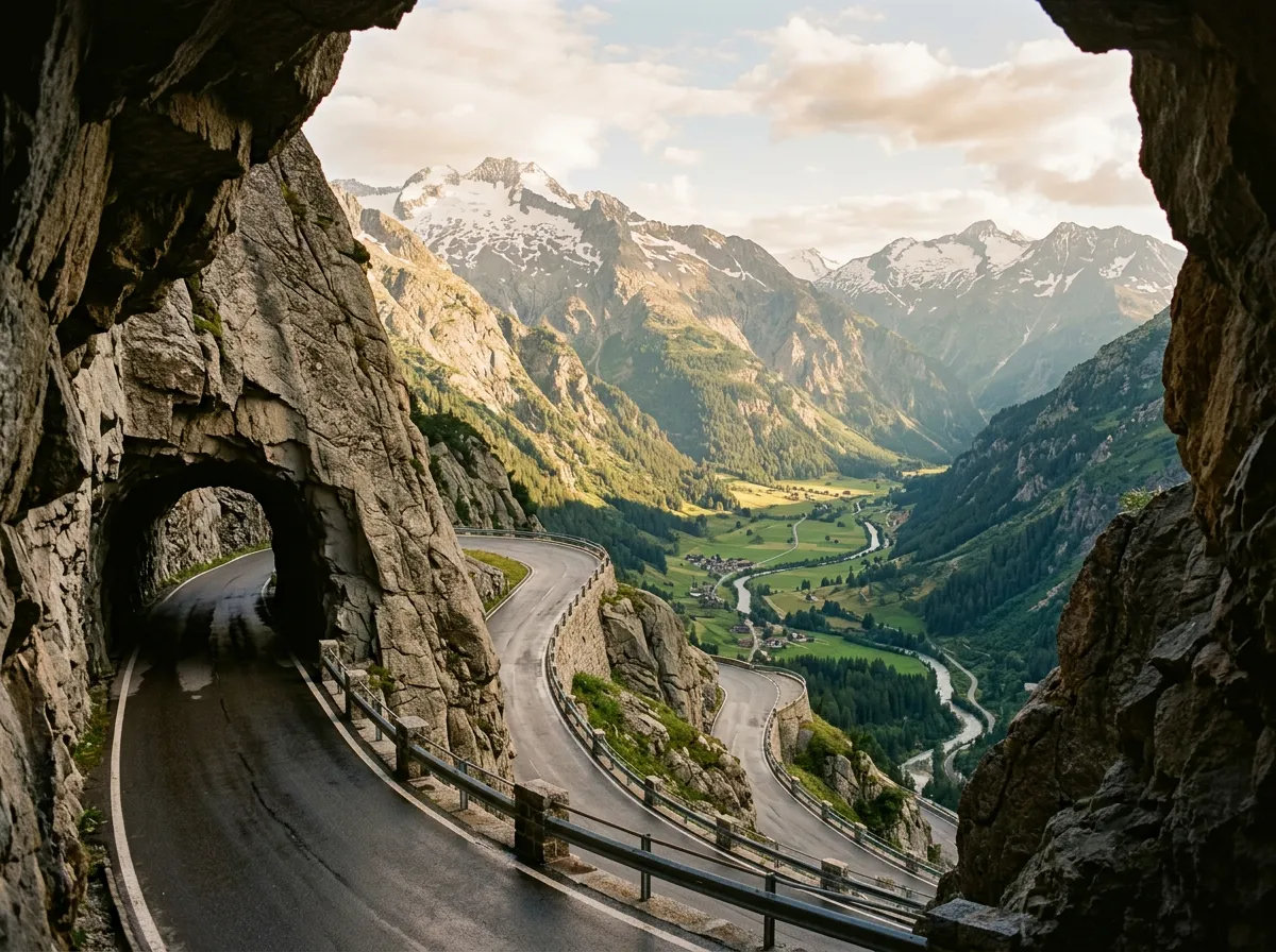
Km 15-20: The northern descent and Räterichsbodensee
The northern side of the Grimsel drops more steeply than the south, losing over 1,500 meters in roughly eleven kilometers. The road passes through several tunnels and gallery sections blasted through the cliff face during the hydroelectric construction era. Some of these galleries have open sides, offering sudden views of the Aar Valley far below — the effect is like looking through a window that someone has punched through solid rock.
The Räterichsbodensee, another reservoir, appears below the road as a stripe of blue-green water in a narrow valley. The road descends alongside it, with good opportunities to pull over and photograph the dam infrastructure that is both brutally functional and oddly beautiful.
Km 20-26: The Haslital Valley and Innertkirchen
Below the reservoir zone, the landscape returns to something recognizably alpine: conifer forest, meadows, the sound of cowbells. The road widens and the gradient eases as you descend into the Haslital, the upper section of the Aar Valley. The town of Guttannen appears first, followed by a scenic valley road that leads to Innertkirchen.
Innertkirchen sits at the junction of the Grimsel and Susten roads. If you are continuing to the Susten, turn east here. If you have had enough passes for one day, Meiringen is ten minutes further north — a proper Bernese Oberland town with hotels, restaurants, and the Reichenbach Falls, where Sherlock Holmes met his temporary end. Between Bond on the Furka and Holmes in Meiringen, this corner of Switzerland has an outsized relationship with British fictional characters.
Practical information
| Detail | Information |
|---|---|
| Opening dates | Typically early June to mid-October |
| Toll | None |
| Fuel | No fuel on the pass. Last fuel south: Oberwald (before Gletsch). Last fuel north: Innertkirchen. |
| Parking | Free at Totensee (summit), Grimsel Hospiz, and several pull-offs on both sides |
| Best time of day | Midday for best light on the granite and lakes; morning for fewer cars |
| Avoid | Nothing specific — the Grimsel rarely has problematic traffic |
| Length | 26 km Gletsch to Innertkirchen |
| Drive time | 45-60 minutes without stops |
| Facilities | Hotel and restaurant at Grimsel Hospiz. Nothing else on the pass itself. |
Combine with nearby passes
Grimsel + Furka: The classic pairing. Drive the Furka east-to-west from Realp, drop into Gletsch, and immediately climb the Grimsel northward. Two completely different passes sharing a single junction. Total drive time: 2-3 hours.
Grimsel + Susten: From Innertkirchen (north end of Grimsel), the Susten begins just a few kilometers east. This is a natural chain — the Grimsel’s lunar granite gives way to the Susten’s sweeping curves and glacier views. Allow 3-4 hours for both.
The full chain: Furka, Grimsel, Susten in one day — this is the core of the Alpine Pass Pentathlon, and the Grimsel is the middle act. Start early and you will finish with daylight to spare.
The Grimsel does not try to impress you. It has no film credits, no famous hairpin photographs, no Instagram hashtags. It just sits there in its granite landscape, waiting for drivers who care more about atmosphere than adrenaline. We have come back to it more often than any other Swiss pass, and each time the Totensee is a little darker, the granite a little more polished, and the silence at the summit a little more complete.